River Wye
The Tragic Fogbound End of the River Wye: A Nova Scotia Shipwreck Tale
Highfield Hunter
In the grey dawn of November 24, 1923, the British cargo steamer River Wye—a weathered survivor of World War I’s brutal seas—met its end on the jagged rocks off Port Mouton Island, Nova Scotia. What began as a routine coal run from Saint John, New Brunswick, to Boston turned into a harrowing tale of fog, mis-navigation, and narrow escape, etching the ship’s story into Atlantic Canada’s maritime lore.
From Teesside Shipyard to Tramp Trader
Launched in 1906 as SS Glamorgan by Craig, Taylor & Co. Ltd. at their Thornaby-on-Tees yard on England’s River Tees, the 3,576 GRT steel steamer measured 342 feet long with a 51-foot beam. Built for Jenkins Bros. of Cardiff (yard #~140), she was renamed River Wye later in her career. The yard, founded in 1885 amid Teesside’s industrial boom, specialized in versatile tramps and colliers, producing over 300 vessels before closing in 1931 due to the Great Depression.
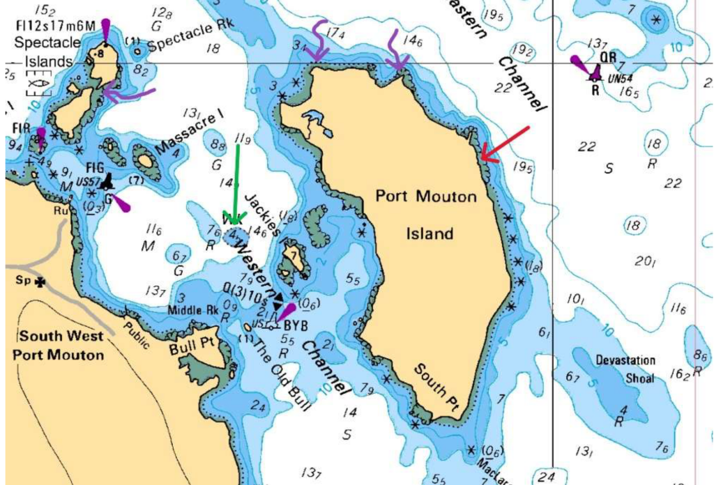
features, depth contours (5-22 meters shown), and marked wrecks (River Wye (red) and Matthew Atlantic (green, also
three potential wrecks (purple)). The stranding location aligns with charted shallow water and rocky hazards that claimed
the River Wye in 1923.
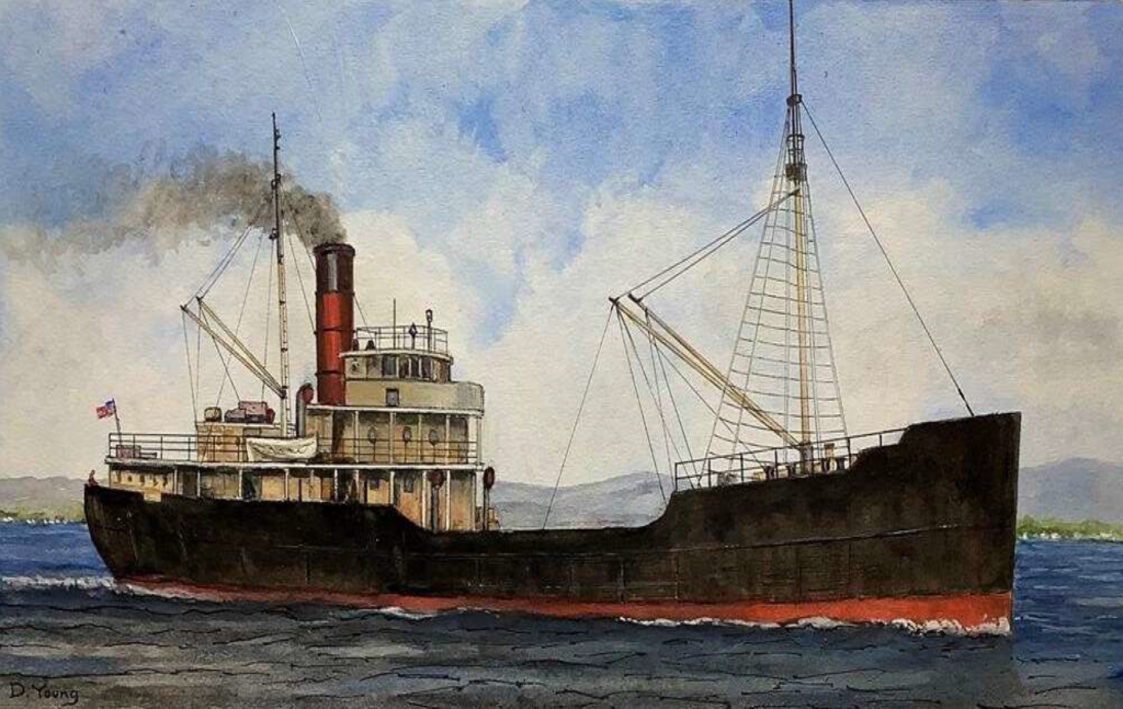
characteristic single red funnel, two-mast configuration, black hull with red anti-fouling bottom, and steel construction.
This vessel type exemplifies the tramp steamer design that defined River Wye’s class and operational profile
River Wye embodied the era’s tramp steamer life: shuttling coal from UK ports to South America, the Mediterranean, and North American grain/coal trades. Owned by Llewellyn, Merrett & Price of Cardiff—which managed the vessel through the post-WWI era—she passed hands following the decline of the traditional tramp steamer trade. No major incidents marred her record until that fateful 1923 voyage.
The Final Voyage: Fog’s Deadly Deception
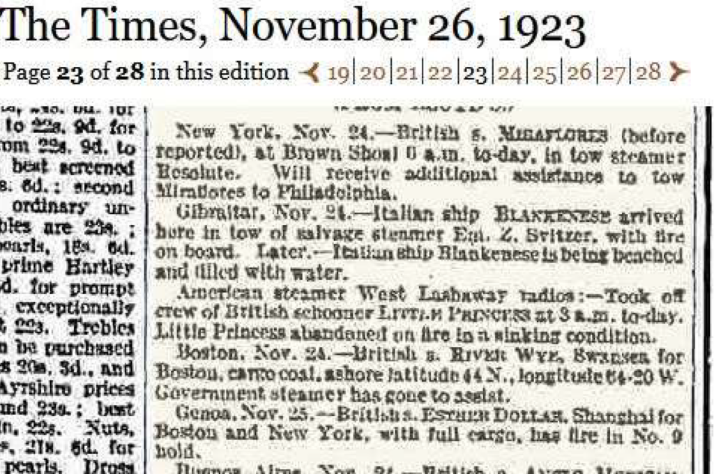
On November 22, Captain David Williams departed Swansea (UK) with 27 crew, loaded with coal for Boston (US). Fog rolled in thick off Nova Scotia’s south shore, a notorious hazard for coastal shipping. From a prior fix at 44°46’N, 61°21’W, the ship steered S. 62° W at 7.5 knots, but without celestial sights, their position unraveled.
At ~6:15 a.m. on the 24th, lookout David Evans peered into the murk—visibility under 14 ship lengths (~250 yards)—and saw nothing until the crunch of rocks at Port Mouton Island (initial reports: 44°00’N 64°20’W). The ship stranded near the island amid stormy seas, becoming a total constructive loss valued at £40,000. Remarkably, no lives were lost; all hands abandoned ship and were rescued by the local Port Mouton residents.
official notification of the vessel’s stranding near Port Mouton Island and rescue of the crew.
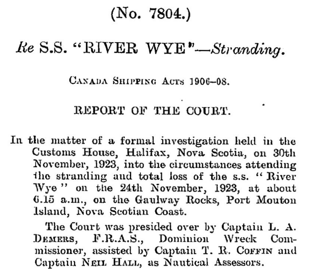
Customs House, November 30, 1923, under Dominion Wreck Commissioner Capt. L.A. Demers, F.R.A.S
Precise Wreck Location and Accessibility
Updated coordinates pinpoint the site at 43°54.487′ N, 64°45.418′ W (decimal: 43.9081° N, 64.7570° W), off the island’s east coast amid rocky ledges in 20-50 feet of water—ideal for recreational diving from Halifax, just a two-hour drive (~150 km southwest). This nearshore spot aligns with Port Mouton’s nautical charts and local 1923 stranding records.
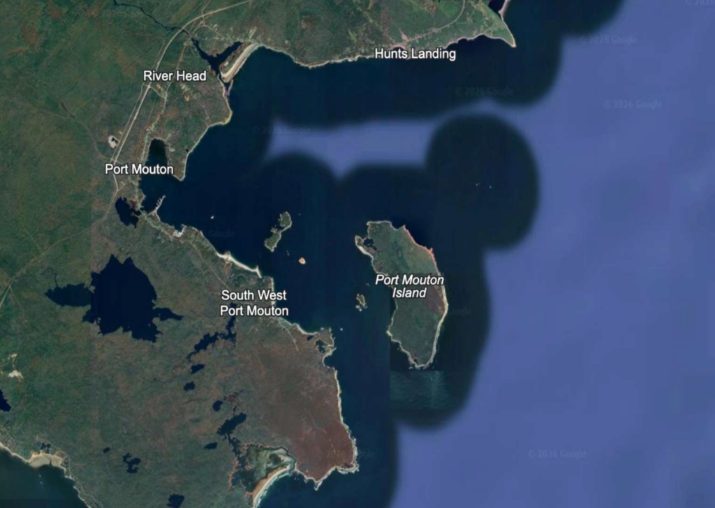
Point, Hunts Landing, River Head, and Port Mouton settlement. The wreck site coordinates (43°54.487’N, 64°45.418’W)
place the River Wye wreck off the island’s east side amid rocky outcrops and shallow waters.
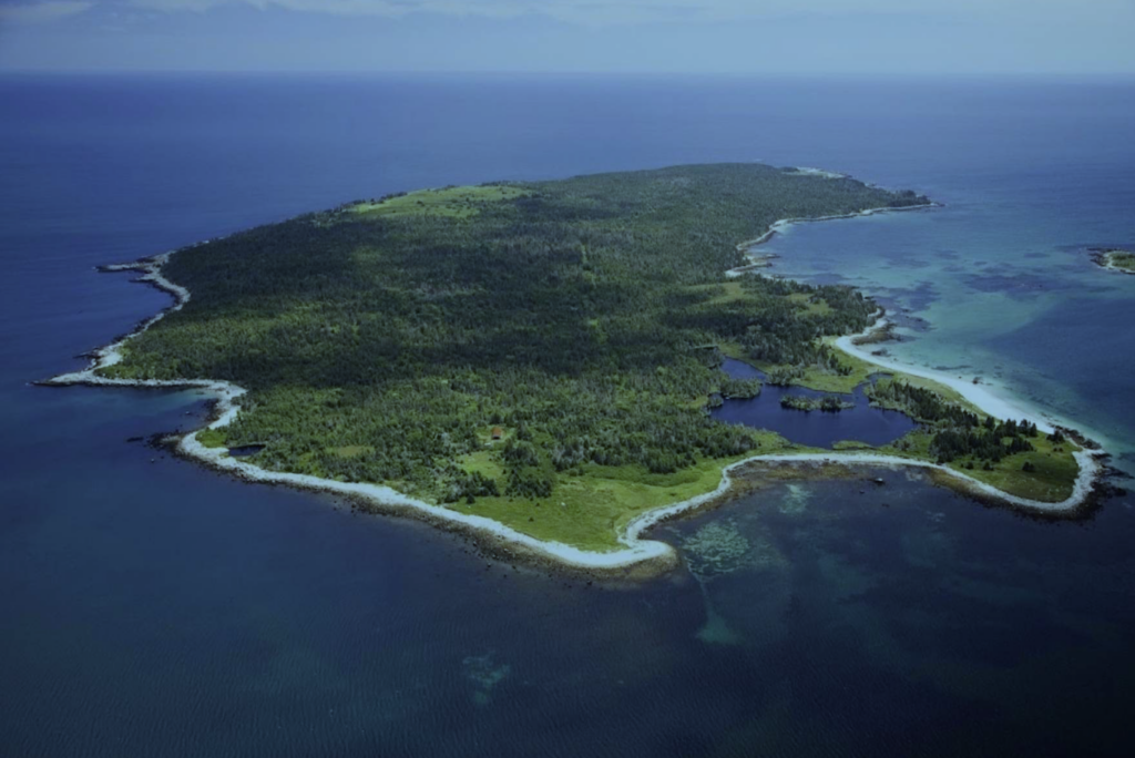
River Wye stranded on the eastern side (left side of photo. The rocky ledges and shallow offshore waters visible in this
image match the hazardous conditions documented in the 1923 inquiry records.
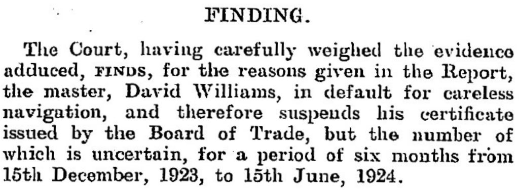
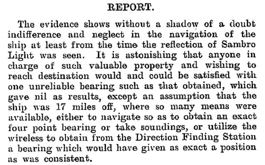
The Halifax Inquiry: Blame on the Bridge
The formal investigation (No. 7804) conducted November 30, 1923, at Halifax Customs House under Dominion Wreck Commissioner Capt. L.A. Demers, F.R.A.S., with Assessors Capt. T.R. Coffin and Capt. Neil Hall. Witnesses—Master David Williams, 2nd Engineer G.J. Humphrey, 2nd Officer J.E. Herbert, 1st Officer R. Jones, wheelsman J.T. Garnett, and lookout David Evans—detailed the haze post-unreliable noon fix (44°46’N 61°21’W) and single Sambro Light bearing. The Court condemned Williams’ “indifference and neglect” for skipping soundings, Chebucto Head wireless bearings, or fixes despite SE winds; Herbert was censured for poor lookout amid visibility disputes (4-5 miles claimed vs. Evans’ 1 shiplength). Williams’ certificate was suspended 6 months (Dec 15, 1923–Jun 15, 1924); others mostly exonerated. The verdict highlighted the River Wye (3,576 GRT, Official No. 123170; Swansea to Boston) as lost to careless navigation on a prudent coast.
Port Mouton, a rugged outpost on Nova Scotia’s “Gravely Coast,” claims another chapter in the province’s 20th-century wreck tally. River Wye’s story endures as a cautionary saga of human error against nature’s veil—her bones a potential gem for local maritime research.
Modern Rediscovery: Pinpointing with Side-Scan Sonar
Fast-forward a century: though previously dove, the wreck’s precise coordinates were elusive until August 31, 2025, when—operating from my Highfield Patrol 760—I towed side-scan sonar across promising sections near Port Mouton Island. The Patrol 760 handled the towing configuration flawlessly, maintaining stable positioning even in choppy tidal currents, while high-resolution acoustic imaging revealed a distinctive “feather-like” shadow.
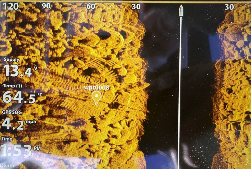
hull structure. The high-resolution sonar data clearly reveals the exposed ribs and framing of the steamer wreck. Waypoint
wpt0008 marks the sonar contact at coordinates 43°54.487’N, 64°45.418’W. The sonar target display shows supply voltage
13.4V, temperature reading 64.5°F, and GPS speed-over-ground of 4.2 mph, documenting the precise survey conditions.
Depth indicator: approximately 30 feet.
This methodical survey paid off with the shipwreck finding, validated by subsequent diving; Highfield’s rugged aluminum design proved essential to this breakthrough, enabling precise gear deployment where lesser boats would struggle. Today, the wreck features lots of wreckage to explore including a 120-foot shaftline precariously spanning large boulders, offering recreational divers a thrilling swim-under passage.
Experience Maritime Nova Scotia: Legacy & Discovery
The River Wye rests in 20-50 feet of Atlantic waters—accessible yet challenging—a time capsule of Edwardian maritime tragedy. Port Mouton Island represents everything Atlantic Canada offers: rugged coastline, fishing heritage, protected harbors, and underwater archaeology. The River Wye discovery showcases modern survey capability meeting historical passion—available now to divers, researchers, and maritime enthusiasts.
From Highfield’s aluminum hull weathering choppy seas to local fishing charters supporting certified divers, the region’s economy has access and adventure. The 988-acre island’s white-sand beaches and wooded trails complement world-class wreck diving. Port Mouton is considered the largest private island on the east coast. This shallow wreck exemplifies Nova Scotia’s untapped maritime potential: dozens more lie undocumented along the south shore, waiting for the next generation of Highfield Hunters. Your dive could be the next rediscovery.
Plan Your Port Mouton Expedition
Getting There: 2-hour drive from Halifax via Highway 103 to Exit 21. Turn left on Port Mouton Connector Road, then right on Number 3 Highway. Continue left on Central Port Mouton Road, then left again on Central Port Mouton Breakwater Road to harbor access (15 min west of Liverpool).
Lodging & Dining:
- Port Mouton Bay Cottages & Restaurant
- Quarterdeck Resort, Summerville Centre
- White Point Beach Resort, Hunts Point
Diving:
- Bring your own boat or contact local fishermen at Port Mouton Harbour to arrange charters
- Primary: River Wye (43°54.487′ N, 64°45.418′ W | 20-50ft | east side island)
- Secondary: Matthew Atlantic artificial reef (~60ft | inboard side of Port Mouton Island | marine life hotspot)
Local Resources:
- Port Mouton Harbour Authority: 902-683-2555
Wreck Coordinates:
- River Wye: 43°54.487′ N, 64°45.418′ W | 20-50 ft | Sand/Rock
- Boat Ramp: 43°55.135′ N, 64°50.616′ W
Vessel Specs: River Wye — 3,576 GRT, 342 ft × 51 ft, Steel Hull, 120-ft Shaftline
Modern survey technology—when paired with rigorous historical research and professional dive operations—continues to reveal and preserve the stories of vessels long thought lost to time and tide. The Port Mouton region stands ready to welcome the next generation of maritime explorers.
Dive Safety Notice: Professional dive operations are strongly recommended. Strong tidal currents and challenging sea conditions require proper training, equipment, and local knowledge. These shared coordinates now guide future explorers, blending SCUBA with Nova Scotia’s maritime heritage.
The confirmation of the River Wye’s location represents a meaningful contribution to Atlantic Canada’s maritime archaeology. The wreck’s depth, proximity to Halifax, and well-documented historical record make it an exceptional site for future research, documentation, and recreational diving education. Modern survey technology—when paired with rigorous historical research and professional dive operations—continues to reveal and preserve the stories of vessels long thought lost to time and tide.
Mentioned In