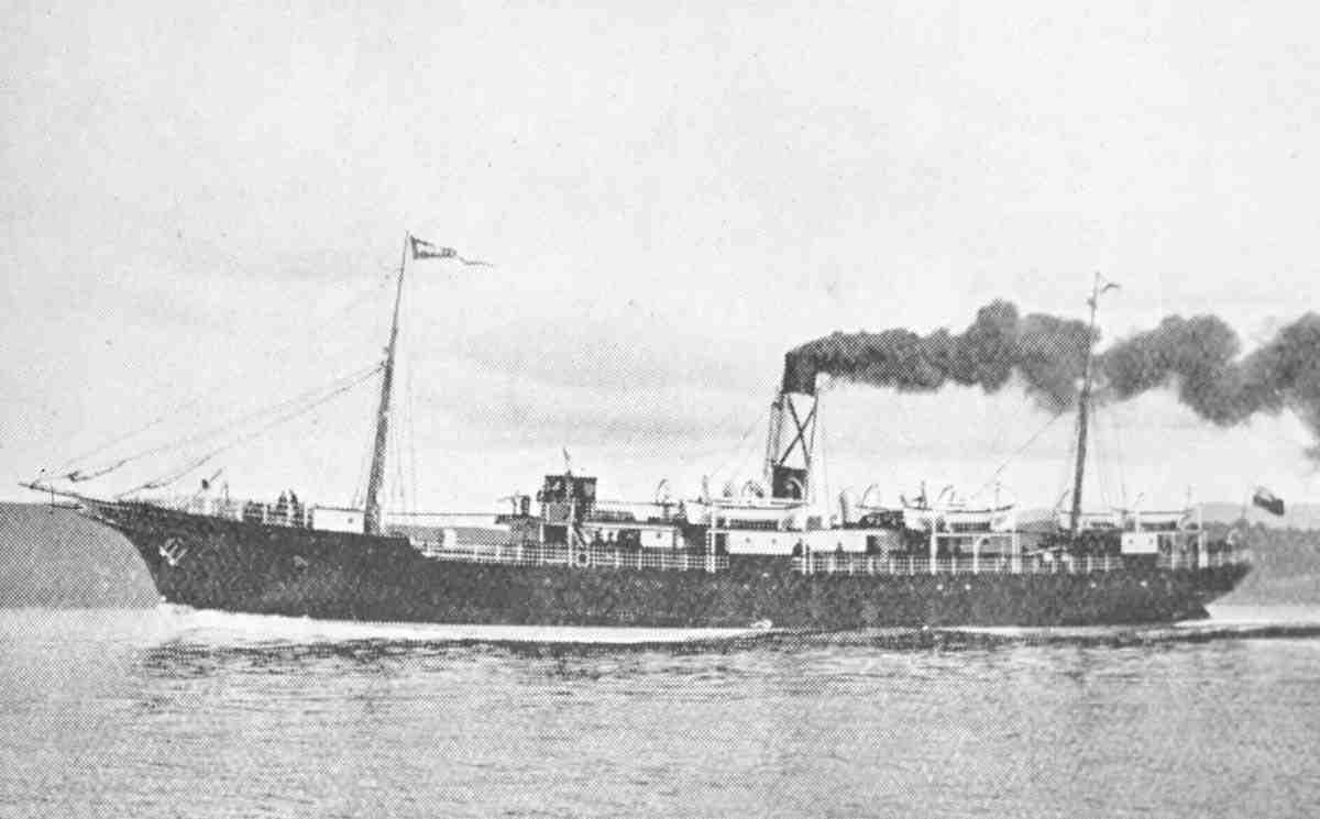
Portia
Carried Beyond the Shoal: The Wreck of the Steamship Portia. 1899.
The Portia was not a ship out of place in the North Atlantic.
Built in 1884 at Newcastle-on-Tyne by Wigham Richardson & Co., she was an iron screw steamer of practical design—strong, efficient, and intended for steady commercial work. At roughly 220 feet in length, driven by a compound engine, she was built not for spectacle, but for reliability.
Cargo below. Passengers above.
She carried both without distinction.
Her route linked New York, Halifax, and St. John’s—part of a growing corridor of movement along the northeastern seaboard. These were not isolated ports. They were connected points in a working system.
The Portia belonged to that system.
A Working System
The Portia did not sail for herself.
Owned by the New York, Newfoundland & Halifax Steamship Company—better known as the Red Cross Line—she operated within a structured commercial network. Behind that system stood Bowring, a name tied to reliability, schedule, and continuity.
Ships like the Portia were expected to move.
Schedules mattered. Cargo mattered. Passengers expected arrival—not delay. And within that system, decisions were rarely made in isolation. They were shaped by expectation.
So ships continued.
Even in fog.
The Coast Off Nova Scotia
The approach to Nova Scotia was not forgiving.
Low land. Broken rock. Shoals extending farther than expected. In clear weather, a careful navigator could read the coast. In fog, it became something else entirely.
Invisible.
There was no line separating safe water from danger—only depth, measured through soundings. And beneath the surface, currents moved quietly, setting vessels inward without obvious indication.
Not abruptly.
Not enough to alarm.
But enough.
On a coast like Sambro, the difference between safe water and grounding was not measured in miles—
but in minutes.
Why Ships Continued in Fog
Fog was not unusual. It was expected.
Ships did not wait for it to clear. They could not. To stop meant delay. To delay meant disruption across an entire chain of movement.
So they continued.
They relied on soundings, dead reckoning, and experience. And most of the time, that was enough.
That is what made it dangerous.
Because repetition builds confidence.
And confidence becomes assumption.
The Voyage
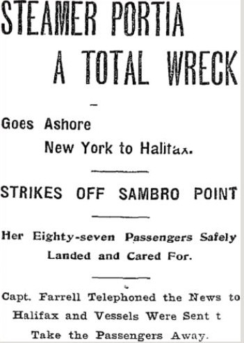
On July 10, 1899, the Portia departed New York bound for Halifax.
The voyage began without incident. By the time she approached Nova Scotia, she was following a familiar route—one navigated countless times before.
Soundings were taken.
Course was held.
The ship was believed to be well offshore.
But as the day progressed, the fog thickened.
By noon, there was no land in sight.
By afternoon, still none.
At approximately six o’clock, a sounding was taken:
Fifty-two to fifty-three fathoms.
Hard bottom.
It was information.
But it was not acted upon.
No further soundings were taken.
The vessel continued.
The Final Hour
From that moment forward, the difference between what was known—and what was acted upon—began to widen.
No correction of course.
No full reduction of speed.
No allowance for current.
The ship continued on what was believed to be a safe track.
But she was no longer where she was thought to be.
And with every passing minute, that difference increased.
The Grounding
At approximately 6:50 p.m., the Portia struck.
There was no warning.
No breakers. No shoreline. No visible sign of danger.
Only the sudden, grinding shock beneath the hull.
Engines were reversed. For a moment, there was still uncertainty—ships had grounded before and come free.
Then came the second impact.
Heavier. Decisive.
The bow held fast. The stern lifted in the swell. Water began to enter.
From that point forward, the ship was no longer navigating.
It was reacting.
The Boats
There was no panic.
That detail holds across every account.
Orders were given. Boats cleared. Passengers gathered. Women and children were lowered first.
The swell made everything difficult—boats rising and falling against the hull—but the crew worked with control.
Passengers later spoke of calm. Of direction. Of officers moving deliberately.
They did this well.
Within forty minutes, the boats were away.
Carried Beyond the Shoal
The Portia did not sink where she struck.
That detail matters.
Lifted by motion and sea, she was carried beyond the shoal—into deeper water.
And there, she settled.
The moment of impact was not the moment of loss.
The loss came after.
The Missing Passenger
At first, the reports were simple:
All saved.
But they were wrong.
A boy was missing.
Twelve years old. Traveling alone. Bound for his mother in Newfoundland. His identity shifted between accounts—Assyrian, Italian—never fully settled.
He had been below deck. Seasick. Out of sight.
And in the urgency that followed, the visible were saved first.
The unseen were not.
The Enquiry
The findings were clear.
- The vessel had been navigated too close to land in fog
- Speed had not been sufficiently reduced
- Soundings had not been maintained
- No allowance had been made for current
- The master had not remained on the bridge
The evacuation was commended.
But one life had been lost.
The master’s certificate was suspended for six months.
The Wreck Today
More than a century later, the Portia remains.
You do not come upon her by accident. You go looking.
The descent is through cold, green water. Then gradually, the structure begins to appear.
Not as a ship.
What remains lies low—flattened, broken, spread across the seabed.
Two lines mark the edges where the hull once stood. Between them, twisted metal, piping, and beams collapse inward and outward at once.
And then—the boiler.
Large. Round. Still intact.
The wreck lies in sixty to seventy feet of water.
The seabed is sand—and that sand does not stay still.
A diver’s movement reveals what lies beneath: beams, pipe, fragments of structure. Sometimes, something more distinct.
A porthole.
Half buried. Waiting.
And scattered throughout—
white, hexagonal tiles.
Small remnants of interior space, now separated from it entirely.
They do not belong to the wreck as it is now.
But they belong to what it was.
Reading the Wreck
A single dive is not enough.
It takes repetition—different light, different current, different perspective.
Because the wreck does not present itself as an object.
It reveals itself as a sequence.
The angle. The spread. The collapse.
You begin to understand not just where she lies—
but how she came to be there.
What Remains
The loss of the Portia has been explained.
But the wreck tells a different story.
Not of recklessness—but of routine.
A system that depended on ships continuing forward—even in conditions that reduced certainty to assumption.
Fog was not a reason to stop.
It was something to move through.
And most of the time, that worked.
A Margin Measured in Minutes
The difference between arrival and loss was not distance.
It was not miles offshore.
It was time.
Minutes between soundings.
Minutes off the bridge.
Minutes between warning and action.
And in that space—
the margin disappeared.
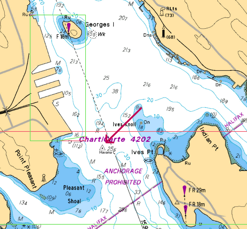
Plan Your Sambro Expedition
Getting There:
30 minute drive from Halifax via Highway 349. Turn left on Sambro Wharf Road
Diving:
- Bring your own boat or contact local fishermen to arrange charters.
- Halifax Dive Shops may provide charters – check their respective websites.
- Primary: Portia (44°26.919' N, 63°35.127' W | 60-70ft |south side island).
Local Resources:
- Sambro Harbour Authority: 902-471-2301
Ask me about the Highfield and Suzuki offshore expedition platform — engineered for serious divers.
#HighfieldHunter #HighfieldPatrol760 #SuzukiEngines #HalifaxShipwrecks #NSMaritimeHistory #NovaScotia #ShipwreckHunter #Portia #NorthAtlantic #DivingHistory
Havana
The Sudden Harbour Loss of the S.S. Havana (1891–1906)
Highfield Hunter
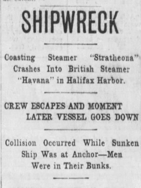
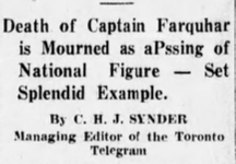
In April 1906, the steam schooner Havana did not vanish in a North Atlantic gale. She did not strike ice, nor founder on a remote reef. Instead, she sank in Halifax Harbour — within sight of the city’s wharves, warehouses, and growing industrial waterfront. Struck while at anchor by the outbound steamer Stratheona near Point Pleasant, Havana slipped beneath the surface in roughly ten minutes. No lives were lost. Yet the vessel belonged to Captain James Augustus Farquhar — one of Nova Scotia’s most accomplished maritime figures — and that fact transforms a minor harbour casualty into a story of transition, irony, and enduring legacy.
The Collision — Halifax Harbour, April 1906
Contemporary reports describe Havana lying at anchor when the coasting steamer Strathcona, bound outward from Halifax, collided with her. Captain Farquhar and most of the crew were asleep below decks; only the watch remained on duty. The impact was decisive.
Crew members rushed topside and were taken aboard the Stratheona. Within minutes, Havana was beyond recovery. There was no prolonged distress, no drawn‑out salvage attempt — just a swift, efficient sinking in one of Canada’s busiest working harbours.
Primary Source Extract:
“With the exception of the watch on deck… Within ten minutes the Havana disappeared.”
The brevity of the event is striking. Many Atlantic shipwrecks unfolded in dramatic weather, but Havana was undone not by storm, but by proximity — a reminder that danger persists even in sheltered waters.
Sable Island — A Childhood in Wreck Culture
To understand Havana’s deeper meaning, one must begin on Sable Island. Captain James Augustus Farquhar’s formative years were spent in an environment defined by shipwreck. Sable Island’s shifting sandbars had claimed hundreds of vessels, and salvage operations were a routine part of island life.
Growing up amid grounded hulls and recovery efforts, Farquhar learned early about navigation, risk, and the mechanics of maritime survival. Wreck was not merely tragedy — it was discipline, technical challenge, and opportunity.
This upbringing shaped a mariner comfortable with calculated risk. It explains his later mastery of deep‑sea diving and salvage, and it frames the quiet irony of Havana’s fate: a man raised among wrecks would eventually lose a vessel of his own — not offshore, but in the harbour he knew best.
Havana — A Transitional Working Vessel
Built in 1891 at Hantsport, Nova Scotia, Havana was a three‑masted steam schooner representative of the transitional era between sail and steam. Traditional rigging remained economically useful, while mechanical propulsion provided reliability and maneuverability in harbour and coastal trade.
Such vessels were practical rather than glamorous. Havana was not a passenger liner nor a naval vessel, but a working ship engaged in sealing and coastal commerce — the backbone of Atlantic Canada’s maritime economy.
Her loss therefore interrupted not only a voyage, but a system of trade and seasonal enterprise closely tied to the ambitions of her owner.
The Builder – Hantsport and the Churchill Yard
The Havana was built in 1891 at Hantsport, Nova Scotia, by shipbuilder George W. Churchill, a name rooted deeply in one of the province’s most productive shipbuilding families.
To understand the vessel, you have to understand where she came from.
Hantsport, sitting along the tidal estuary of the Avon River at the edge of the Minas Basin, was not simply a village—it was a shipbuilding engine. The extreme Fundy tides, nearby timber resources, and direct access to Atlantic trade routes made it an ideal place to build and launch wooden vessels.
At the center of this industry was the Churchill shipyard, founded by George’s father, Ezra Churchill, one of the most influential shipbuilders in 19th-century Nova Scotia. From the 1840s onward, the Churchill operation helped transform Hantsport into a major maritime construction hub, producing dozens upon dozens of large wooden vessels for Atlantic trade.

By the mid-19th century, the yard had launched everything from brigs and schooners to massive ocean-going barques—some among the largest ever built in Canada. The scale of production was such that the Churchill fleet became both a shipbuilding enterprise and a shipping network, moving timber, gypsum, and cargo throughout the North Atlantic world.
When Ezra stepped back, George Washington Churchill (1835–1906) took over management of the yard and continued operations into the final decades of the wooden ship era.
It was during this later period—when steam power was beginning to merge with traditional sail—that the Havana was constructed.
A Vessel of Transition
The Havana reflects that exact moment in maritime history.
Built as a three-masted steam schooner, she combined sail with auxiliary steam propulsion—a practical evolution rather than a radical one. This was not a luxury vessel or a deep-ocean liner. She was a working ship, designed for the demands of sealing, salvage, and coastal trade—industries that defined Atlantic Canada at the time.
By 1891, yards like Churchill’s were adapting. Iron and steel ships were beginning to dominate global trade, but in places like Nova Scotia, wooden vessels still filled critical regional roles. The Havana represents one of the last generations of locally built wooden working ships, bridging the gap between two eras.
The End of an Era
There is a quiet significance in this.
The same forces that allowed the Churchill yard to thrive—timber, tides, and skilled labour—were becoming less relevant in a world shifting toward industrial shipbuilding. Within a few decades of Havana’s construction, the great age of wooden shipbuilding in places like Hantsport would collapse under the pressure of steel hulls and centralized industrial yards.
George W. Churchill himself died in 1906—the same year Havana was lost in Halifax Harbour.
It is a coincidence, but a fitting one.
Both the man and the vessel belonged to the closing chapter of a distinctly Nova Scotian industry—one that built ships not in massive factories, but along tidal rivers, where hulls rested in the mud at low tide and floated free on the rise.
Yard Inset – Building with the Tides
Shipbuilding at Hantsport did not take place in dry docks or controlled basins. It happened in the open—on the banks of the Avon River—where the tides of the Minas Basin governed everything.
Here, the rise and fall of the water could exceed 40 feet. At low tide, the river withdrew completely, leaving vessels sitting upright in thick mud, their hulls exposed for work. Shipwrights moved freely beneath them, shaping frames, fastening planks, and driving treenails into green timber. The yard was quiet then—tools against wood, the slow rhythm of construction grounded in the exposed riverbed.
At high tide, everything changed.
Water returned with force, lifting the hulls free. What had been a construction site became, briefly, a working harbour. Materials could be brought alongside, hulls could be shifted, and—when the time came—a finished vessel could be launched directly into the current, carried out toward the Minas Basin and the open Atlantic beyond.
There were no rigid schedules. The tide was the clock.
For builders like George W. Churchill, this was not a limitation—it was an advantage. The tidal system eliminated the need for expensive infrastructure and allowed large wooden ships to be built efficiently using the natural environment itself. It also demanded precision. A missed tide could delay work for hours. A poorly timed launch could be disastrous.
The Havana was built in this setting—its hull rising from the mud in stages, shaped between tides, and finally released into the river on a flood that would carry it out into the Bay of Fundy.
It is a method of construction that feels distant now, but it was once the backbone of Nova Scotia’s shipbuilding tradition—practical, tide-driven, and deeply tied to place.
Lucky Farquhar — From Seaman to Steamship Magnate
James Augustus Farquhar’s life bridged the Age of Sail and the Age of Steam. He went to sea before the mast, rounded Cape Horn in clipper ships, commanded vessels of his own, and later embraced steam propulsion during an era of rapid technological change.
By the time of his death in 1930, newspapers declared that “Farquhar’s luck” had become a Maritime proverb — a phrase standing for bold enterprise and brilliant outcomes.
He was described as master mariner, salvor, deep‑sea diver, and founder of significant Halifax steamship firms. His career exemplified calculated risk supported by discipline and relentless work.
Farquhar’s Own Voice — Farquhar’s Luck
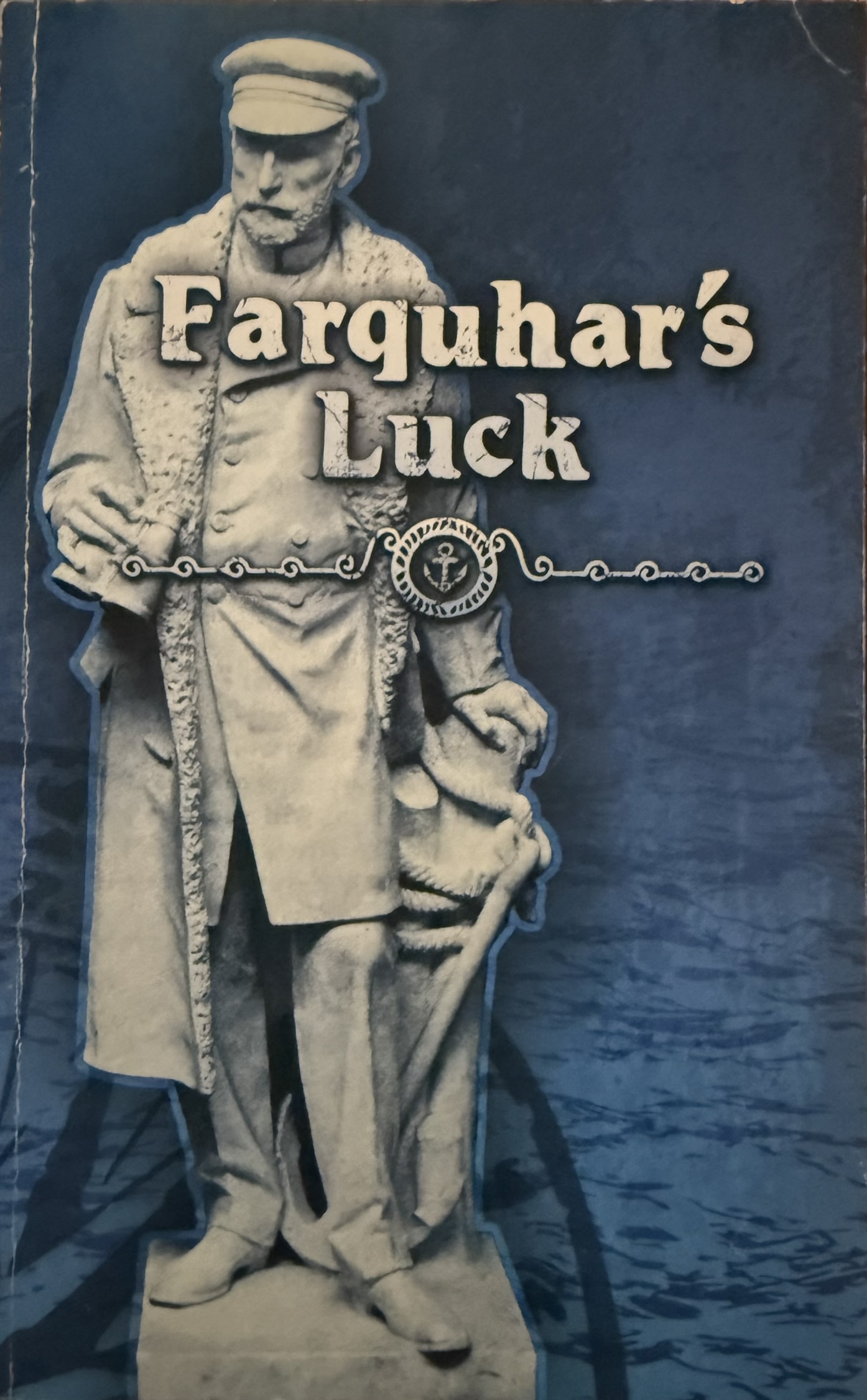
Unlike many mariners of his era, Farquhar left a written record of his life – a chronicle that would later be published as Farquhar’s Luck.
In 1980, fifty years after his death, Captain James Augustus Farquhar’s memoir was published under the title *Farquhar’s Luck*. Drawn from the lively chronicle he kept throughout his life, the book documents a career that stretched from Sable Island wreck culture to steamship enterprise in Halifax.
The title reflects the phrase that became synonymous with his reputation — “Farquhar’s luck.” Yet those who knew him understood that luck alone did not define his success. His writing reveals discipline, calculated risk, and relentless work beneath the mythology.
Through his own words, Farquhar describes his early exposure to wreck and salvage, voyages before the mast, command in the age of sail, adoption of steam power, deep-sea diving operations, and commercial expansion within Atlantic trade networks.
The Havana, lost in 1906, becomes part of a much broader arc — one episode within a life shaped by maritime adaptation and enterprise.
Unlike many vessel owners of his era, Farquhar left a written record. Havana is therefore not simply a submerged structure, but a vessel connected to a documented maritime philosophy.
Today, divers tracing her timbers beneath Halifax Harbour move through a site once commanded by a man who understood both risk and recovery — and who preserved his own account of it for future generations.
The Irony of Salvage
Few aspects of the Havana story are more compelling than its irony. Captain Farquhar learned deep sea diving to enhance his salvage operations, accomplishing numerous rescues throughout Atlantic waters.
Yet Havana afforded no opportunity for recovery. The harbour depth, rapid flooding, and structural compromise rendered salvage impractical. The man who built a reputation recovering wrecks could not recover his own vessel.
This paradox elevates Havana from minor harbour casualty to symbol of maritime limitation — a reminder that even experience and preparation have boundaries.
Harbour Context — Halifax in 1906
By 1906, Halifax Harbour was already a strategically important port. Steam traffic was increasing, anchorages near Point Pleasant were common, and navigation required coordination in confined waters.
Collisions in harbour reveal the risks inherent in industrial expansion. Rather than being lost to storm, Havana was lost to density — a product of proximity within a modernizing maritime environment.
Technical Dive Site Survey — Present Condition
Location: Halifax Harbour near Point Pleasant
Depth: Approximately 80–90 feet
Seabed: Sand and silt overlay with ballast concentrations
Water Temperature: Winter bottom temperatures near 2°C
Visibility: Typically 5–15 feet depending on tidal and vessel activity
Remaining structural elements include timber hull framing, ballast stone mounds, coal remnants, partially buried boiler structure, and isolated fittings. The debris field aligns roughly along the original hull axis.
Active commercial traffic, variable currents, and cold‑water exposure require advanced dive planning, harbour coordination, and surface support monitoring.
Cultural Memory and Enduring Recognition
The Farquhar name endured long after Havana’s loss. Family prominence continued in Halifax society, and decades later, American press still referenced Captain Farquhar and his statue in Nova Scotia.
Through obituary accounts, family notices, and cultural references, the story extended well beyond the harbour floor.

Interpretive Significance
Havana is not remembered for catastrophe or mass casualty. Her importance lies in narrative depth. She represents a transitional vessel owned by a transitional mariner. She illustrates the limits of calculated risk and the quiet hazards of industrial harbour life.
Most harbour wrecks fade into obscurity. Havana endures because her owner’s life story magnifies her significance. Beneath Halifax Harbour, she remains a quiet but meaningful chapter in Atlantic Canada’s maritime heritage.
Modern Exploration — The Highfield Hunter Reaches the Havana (January 10, 2026)
The plan began the evening before. January 9th carried a forecast of scattered showers and west winds pushing 44 km/h, gusting to 66. Halifax in January offers little comfort and less certainty. But winter windows are rare, and hesitation is often the only true barrier. We committed.
Dawn broke cold and metallic. Frost clung to the gunwales as we uncovered the boats and loaded steel tanks into the 25-foot Highfield. A smaller 16-foot aluminum boat trailed behind — practical, stubborn, and loud against the chop. The wind cut across the harbour, but the Halifax Peninsula shielded us from the worst of the west. Engines growled to life. We pushed off.
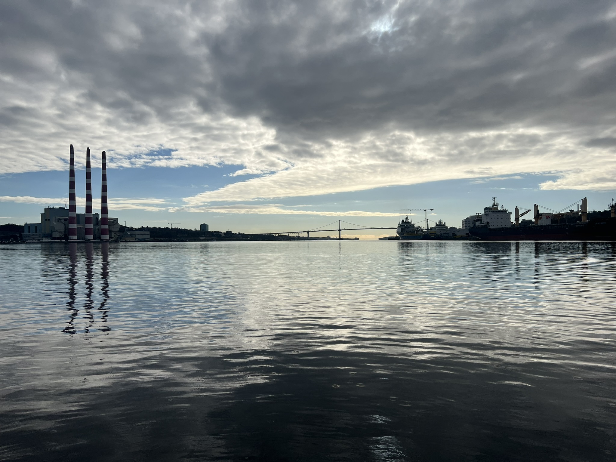
The harbour in winter feels different. The air carries a sharper edge. Sound travels farther. Container cranes loomed against a pale sky while freighters moved deliberately through the channel. We checked in with Halifax Traffic, confirmed diving operations, and took position over the coordinates.
One vessel anchored. The second idled nearby as a tethered chase boat, lines ready and radios monitored. Three of us stepped to the stern. Regulators hissed. Masks sealed. The Atlantic swallowed us in a rush of grey.
The first sensation was temperature. Even through drysuit layers, the cold pressed in — bottom water hovering near 2°C. The descent line shimmered downward into dimness. I expected the usual harbour murk — heavy silt, visibility measured in arm’s length. Instead, as my light cut forward, the water opened to 10, even 15 feet. Shapes began to form.
Timbers emerged from the sand like ribs. Hull sections rose at angles, softened by a century of salt and current. Rock piles — ballast — lay scattered in uneven mounds. Patches of coal stained the seabed black. And there, unmistakable, the boiler rested half-buried — iron rounded and silent beneath silt.
I checked the anchor and began a slow circuit westward, finning carefully to avoid disturbing the bottom. The wreck revealed itself in fragments: a deadeye resting against timber; a curve of brass catching my beam; an intact porthole rim still circular after 120 winters. Clusters of short, stubby shells marked her sealing past — small reminders of the industry she once served.
Above us, unseen, ships continued their passage through Halifax Harbour. Down here, only the rhythm of breath and the muted thud of distant propellers broke the stillness. The wreck felt preserved in suspension — not dramatic, not chaotic, but settled.
After roughly forty minutes, fingers stiffening and computers edging toward ascent profiles, we began our return. The line led upward into brighter grey. Cold air met us at the surface. Engines idled close. Lines were handed up. The city skyline reappeared, unaware.
More than a century earlier, Captain Farquhar mastered hard-hat diving in pursuit of salvage and recovery. On this winter morning, modern divers traced the remains of his vessel in the same harbour. The circle — from Sable Island wreck culture to steamship enterprise to quiet harbour loss — closed again beneath Atlantic water.
Access and Site Permissions
The wreck of the S.S. Havana lies within Halifax Harbour near Point Pleasant at coordinates 44°37.443' N, 63°33.211' W. As the site rests within an active commercial shipping corridor in Canada’s primary Atlantic port, diving operations require prior coordination and authorization. Divers must obtain clearance from Halifax Harbour Authority / Port of Halifax, notify Halifax Traffic (Vessel Traffic Services) before entering the water, and comply with all Transport Canada marine safety regulations. Due to continuous vessel movement, restricted navigation zones, and strong tidal influence within the Narrows and main channel, the site is not suitable for unsupervised or recreational access. Proper surface support, radio monitoring, and formal operational approval are mandatory.
Ask me about the Highfield and Suzuki offshore expedition platform — engineered for serious divers.
#HighfieldHunter #HighfieldPatrol760 #SuzukiEngines #Suzuki-300hp #HalifaxShipwrecks #NSMaritimeHistory #NovaScotia #Halifax #Havana
Norwegian
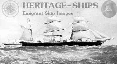
The Fogbound Loss of the RMS Norwegian (1863)
An Allan Line Disaster off St. Paul’s Island
Highfield Hunter
The Morning the Fog Closed In
The Gulf of St. Lawrence lay silent beneath a shroud of white. In the early hours of Sunday, June 14, 1863, the iron mail steamer Norwegian pressed westward toward Montreal, her engines beating steadily against the calm sea. Passengers stirred below decks, unaware that visibility on the bridge had collapsed to a matter of yards. The world beyond the rail had vanished.
Shortly before seven o’clock, the lookout’s voice pierced the fog: “Breakers ahead!” The order came instantly—engines full astern—but the momentum of 3,000 tons of iron and steam could not be arrested in time. With a grinding concussion that shuddered through hull and machinery, Norwegian struck the rockbound flank of St. Paul’s Island. The impact threw her engines out of gear; iron shrieked against stone. Within moments, the proud Allan Line steamer lay hard aground, her voyage ended in the grey silence of the North Atlantic fog.
From Dumbarton Yard to Royal Mail Service
Constructed in 1861 by William Denny & Brothers at Dumbarton, Scotland, Norwegian represented the modern iron screw mail steamer of her age. Barque-rigged and powered by twin 450-horsepower engines, she combined sail and steam in a transitional era of maritime engineering. Her registered tonnage stood at 1,888 tons, with gross tonnage reported at 3,449 tons. Measuring approximately 300 feet in length with a beam of nearly 38 feet, she was a formidable presence on the Atlantic routes.
Owned by the Montreal Ocean Steamship Company—the Allan Line—Norwegian formed part of a fleet that carried Royal Mail, emigrants, and commercial cargo between Liverpool, Londonderry, Quebec, and Montreal. In an era before wireless positioning or radar, her masters relied on compass, chronometer, lead line, and experience to navigate some of the most fog-prone waters in the world.

A Nova Scotia Sister: The Nova Scotian Comparison
Living in Nova Scotia and writing about its maritime past, it is fitting to compare Norwegian with her near-sister steamer Nova Scotian. Both vessels were built in the early 1860s by William Denny & Brothers for the Montreal Ocean Steamship Company and were designed for the demanding Liverpool–Quebec–Montreal mail service. Iron-hulled, screw-driven, and barque-rigged, they represented the modern Atlantic mail steamers of their era—large, powerful, and built to maintain schedule through fog, ice, and current.
Visually, Norwegian and Nova Scotian would have appeared nearly identical at sea: a single funnel, two masts, long iron hull, and a profile emblematic of Allan Line’s expanding presence in Canadian waters. Using Nova Scotian as a comparison vessel provides an authentic regional anchor—particularly meaningful given Norwegian’s loss off St. Paul’s Island—and helps readers visualize the scale and character of the ship as she would have appeared on her final voyage in 1863.
Service Across the Atlantic
Between 1861 and 1863, Norwegian maintained a steady transatlantic schedule. Newspaper shipping columns tracked her departures and arrivals with mechanical regularity—Liverpool to Quebec, Quebec to Liverpool—carrying emigrants seeking new futures and goods sustaining colonial commerce. She transported species, manufactured goods, seeds, textiles, and passengers in both cabin and steerage classes.
The Allan Line prided itself on speed and reliability. But speed in the age of fog carried risk. The Gulf of St. Lawrence, particularly near St. Paul’s Island, had already claimed numerous vessels. Navigators called it the 'Graveyard of the Gulf'—a title earned through sudden weather, hidden reefs, and treacherous currents.
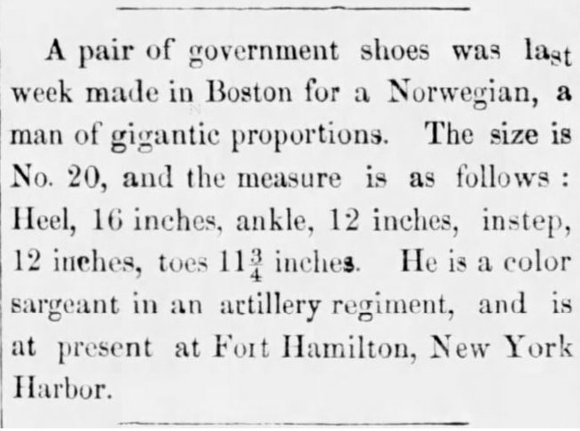
When “Norwegian” Isn’t Norwegian
Researching nineteenth-century newspapers is rarely a straight course. A single keyword can open doors to ship manifests, inquiry transcripts—or something entirely unexpected. During the archival sweep for references to the Norwegian, one article was flagged simply because the word appeared in its headline. It had nothing to do with the Allan Line steamer, St. Paul’s Island, or maritime disaster. Instead, it described a pair of government-issued shoes made in Boston for a Norwegian soldier of extraordinary size—boots measuring nearly sixteen inches at the heel.
Moments like this are part of the rhythm of historical research. Among reports of wrecks, fog, and inquiry proceedings, small human curiosities surface—reminders that the nineteenth-century press was as much about spectacle and novelty as it was about tragedy. Though unrelated to the loss of the RMS Norwegian, the clipping is a fascinating artifact of its time, and worth preserving here as a glimpse into the broader world that shared her name.
The Final Voyage – June 1863
Departing Liverpool on June 4, 1863, and clearing Londonderry the following day, Norwegian set course for Montreal under Captain Andrew McMaster. On board were 59 cabin passengers, 269 steerage emigrants, a crew of 88, and approximately 571 tons of cargo. The crossing was largely uneventful, though seasonal fog thickened as the vessel entered Gulf waters.
As Norwegian approached St. Paul’s Island in dense fog, lookouts strained against near-zero visibility. Despite the engines being reversed upon sighting breakers, the steamer’s forward motion proved unstoppable. The collision was decisive: she struck heavily, listed to starboard, and water surged into one of her holds. The machinery, jolted violently, fell out of gear. The ship’s fate was sealed.
Orderly Escape from Disaster
Yet what might have become a catastrophe instead became a testament to discipline. Boats were lowered in controlled sequence. Passengers were landed ashore at the Human Establishment on St. Paul’s Island—an emergency refuge stocked with provisions by the Canadian Government. Women, children, and emigrants alike found temporary shelter from the elements.
Relief arrived in due course, and survivors were transported onward to Quebec. The Royal Mail was recovered, as were portions of the cargo. In stark contrast to other disasters of the era, not a single life was lost.
The Board of Trade Inquiry
A formal inquiry convened in Liverpool to determine the cause of the loss. Testimony examined navigational decisions, the vessel’s speed in dense fog, compass reliability, and the standard practices of North Atlantic mail steamers. While acknowledging Captain McMaster’s long and distinguished career, the Court ultimately concluded that proceeding at excessive speed in fog constituted default. His certificate was suspended for twelve months.
The ruling reflected the maritime law of the period: even in calm seas and without loss of life, command responsibility in restricted visibility was absolute.
Breaking on the Rocks
Salvage crews removed sails, rigging, and valuable cargo. Contemporary reports valued recovered goods in tens of thousands of dollars. Norwegian lay hard aground, her port side exposed to the swell. Gradually, under relentless Atlantic surge, she broke apart—iron ribs and plating surrendering to sea and time.
She joined the growing list of steamers lost in the era of early transatlantic communication—a casualty not of storm, but of fog and momentum.
Breakers Ahead: St. Paul Island in the Age of Steam
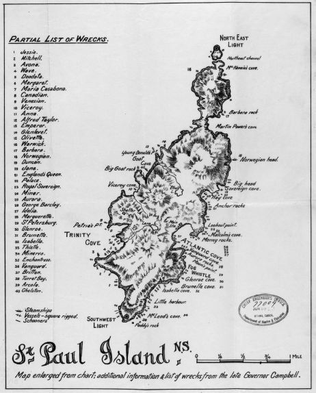
St. Paul Island did not claim the Norwegian alone. Rising abruptly from the Gulf of St. Lawrence, shrouded in fog and battered by converging currents, the island has earned a reputation as one of Atlantic Canada’s most unforgiving maritime hazards. Long before modern navigation, its reefs and shoals tore open hull after hull. The Norwegian became one name among many — part of a tragic roll call that spans decades of Atlantic commerce and emigration.
The Long Way Back

Captured during exploratory dives in 2002, this frame—extracted from original dive video footage—documents exposed deck edges and collapsed iron framing along the debris field. While limited by the camera technology of the time and the typically reduced visibility off St. Paul Island, the image provides early confirmation of structural orientation and preservation state. It represents some of the earliest personal documentation of the site and establishes a continuity of engagement that spans more than two decades.
I first descended onto the wreck of the Norwegian in 2002. I was younger then, eager and focused on machinery, structure, identification. I knew the history — the fog, the breakers, the inquiry in Liverpool — but underwater history is not read; it is felt. The wreck lies in roughly fifty feet of water, sloping into deeper ground along the island’s exposed flank. Even then, I remember the surge — the steady Atlantic pulse that never truly rests around St. Paul Island. Iron frames would appear and disappear as the swell lifted and settled. Kelp streamed past like torn banners. The water was cold, even in summer, the kind of cold that seeps past gloves and settles into your wrists.

Over the next few seasons I returned several times, tracing scattered wreckage and piecing together what I could. Then life moved forward, as it does. Years became decades. The wreck remained, but I did not.
In August 2025, nearly twenty years later, the Highfield brought me back.
Approaching St. Paul Island again felt different. The cliffs still rose abruptly from the sea, dark and indifferent. The same currents curled around the headlands. The same fog threatened to erase the horizon without warning. But this time there was a weight to it — the awareness of time passed, of unfinished curiosity.
We dropped in over eighty feet of water, holding the deeper line of the debris field. The Atlantic greeted us the way it always does — cool, green, and alive with motion. At depth the temperature dropped sharply; the cold pressed through layers and settled in. Visibility shifted with the surge — ten to fifteen feet at best — each swell lifting fine sediment and then letting it fall again like drifting smoke.
Shapes emerged slowly.
A capstan appeared first, heavy and unmistakable, still rooted in the seabed as though waiting for a line to be cast. Sections of boiler plating lay collapsed nearby, curved iron ribs half buried in sand and mussel shell. A porthole frame caught the light — brass dulled by a century and a half of salt water. Hull plates, torn and twisted, lay scattered in long, distorted ribbons that told their own silent story of impact and surrender.
Nothing stands proud. Nothing resembles a ship at first glance. The Norwegian is no longer a vessel — she is a field of iron memory.
The surge worked steadily across the wreckage, rocking even the heavier pieces with a slow, deliberate rhythm. It is impossible to forget, down there, that the same water that now moves you gently once drove her hard onto rock. At moments the only sound was the steady exhale of bubbles and the low, distant rumble of swell transmitting through stone. It is a different kind of quiet — not absence of sound, but the presence of depth.
After twenty years, the wreck felt smaller in some ways, but more significant in others. I was no longer just cataloguing parts. I was aware of time — of the men and women who stood on her decks in 1863, of the captain judged in a Liverpool courtroom, of the decades she has rested in cold Atlantic water. Returning was not just about rediscovery. It was about continuity.
The breakers still roll across St. Paul Island. The iron still rests where it fell. And beneath eighty feet of moving Atlantic water, the Norwegian remains — not intact, not preserved, but enduring.
Plan Your St. Paul Island Expedition
The journey to St. Paul Island deserves its own account. The logistics, weather windows, fuel calculations, tides, and contingency planning required to safely reach one of Atlantic Canada’s most isolated maritime sites are substantial enough for a dedicated article. Operating from a Highfield Patrol platform — built for open-water reliability and predictable handling in exposed conditions — changes what is realistically possible along this unforgiving stretch of coastline.
A comprehensive account of the planning, logistics, and operational details for St. Paul Island can be found in my dedicated St. Paul Island expedition document.
As St. Paul Island lies a significant distance offshore — and several hours’ drive from Halifax — careful planning is essential. Travel from Halifax to Dingwall, if using it as the primary launching point, requires advance coordination and favorable conditions. Alternatively, departure can be made from Bay St. Lawrence, though both routes demand close attention to weather windows, sea state, fuel range, and emergency contingencies before committing to open water.
Getting There:
Departing from Halifax, travel north on Highway 102 toward Truro before merging onto Highway 104 eastbound. Continue along the Trans-Canada Highway toward the Canso Causeway, crossing onto Cape Breton Island. Remain on Highway 104 until connecting with the Cabot Trail.
On this expedition, we crossed the iconic Englishtown Ferry and continued counterclockwise along the Cabot Trail, tracing the island’s rugged eastern coastline. The road narrows and climbs in places, offering sweeping Atlantic views before descending toward the northern communities.
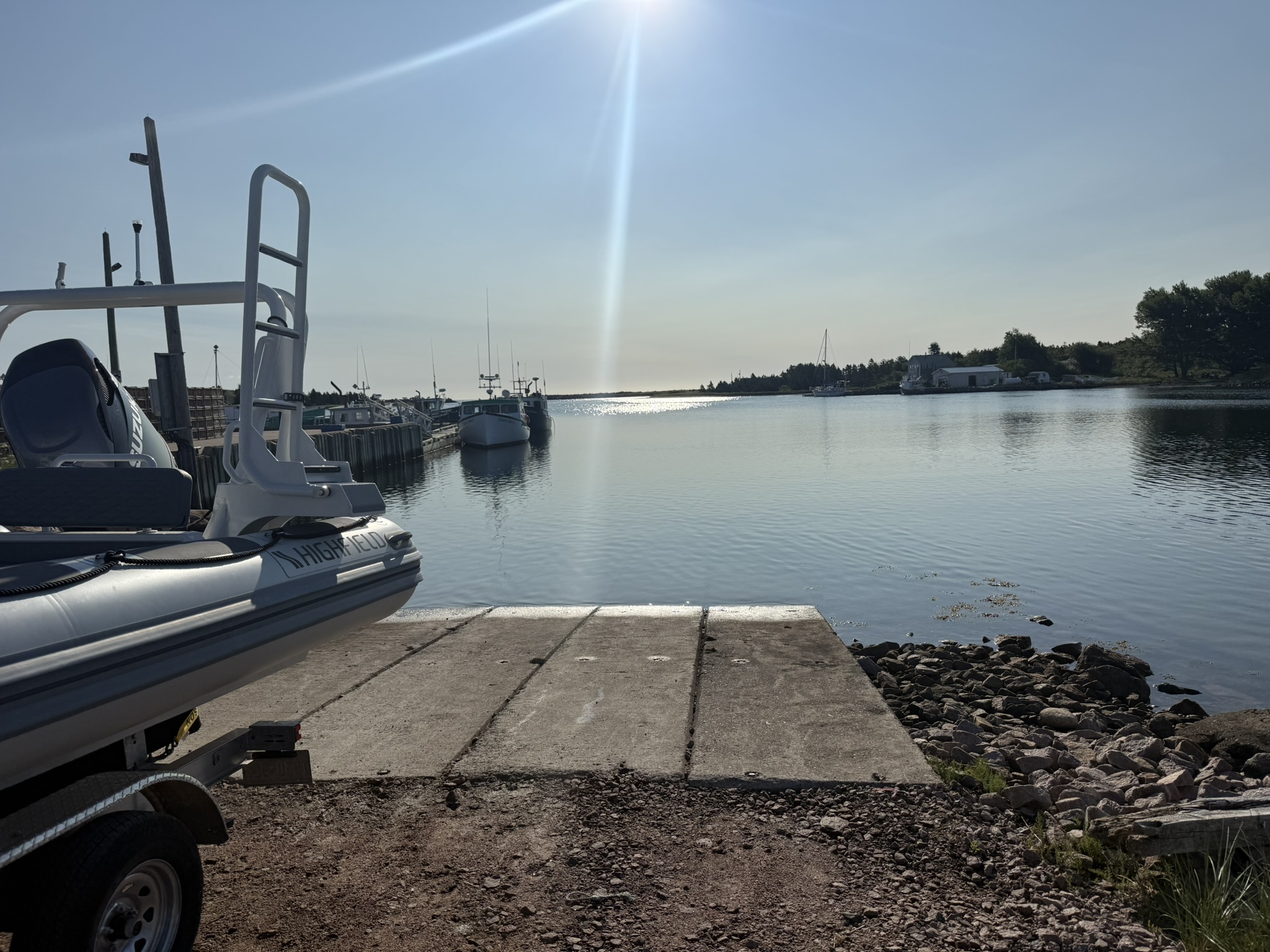
Dingwall Road provides access to the village of Dingwall. From there, turn left onto Mountainview Road and then right onto Quarry Road. This route leads directly to Dingwall Harbour and the public slipway pictured below — the final staging point before committing to open water toward St. Paul Island.

Lodging & Dining:
- Markland Cottages with restaurant
- Various AirBnB
- Angies Restaurant
- ACA’s General Store
Diving:
- Bring your own boat or contact local fishermen at Dingwall Harbour to arrange charters.
- RMS Norwegian (47°12.400' N, 60°08.140' W | 50-100+ft | east side island)
Local Resources:
- Northern Victoria Small Craft Harbour Authority: 902-336-2235
Wreck Coordinates:
- RMS Norwegian: 47°12.400' N, 60°08.140' W | 50-100+ft | east side island
- Boat Ramp: 46°54.173' N, 60°27.616' W
Vessel Specs:
RMS Norwegian — 3,449 GRT, 300 ft × 38 ft, Iron Hull, Twin 450 HP Screw Engines
Dive Safety Notice:
Professional dive operations are strongly recommended. St. Paul Island lies far offshore and well beyond immediate support services. Strong tidal currents, rapidly changing weather, surge, and limited emergency access require advanced training, proper equipment, redundant systems, and experienced surface support. Thorough planning is essential before committing to open water. These shared coordinates are provided for historical reference and responsible exploration, blending SCUBA with Nova Scotia’s maritime heritage.
Ask me about the Highfield and Suzuki offshore expedition platform — engineered for serious divers.
#HighfieldHunter #HighfieldPatrol760 #SuzukiEngines #Suzuki-300hp #HalifaxShipwrecks #NSMaritimeHistory #NovaScotia #StPaulIsland #Norwegian

Matthew Atlantic
Steel, Salt, and Second Lives: The Story of Matthew Atlantic
Highfield Hunter
Names Beneath the Surface
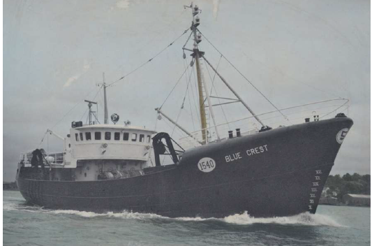
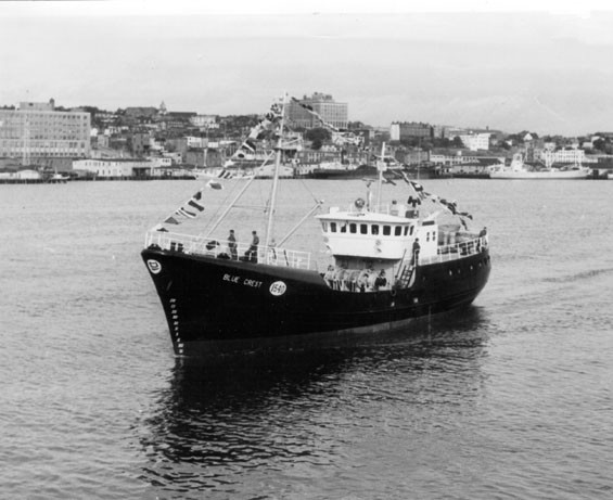
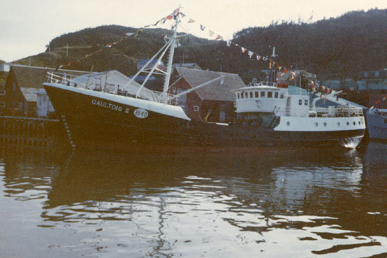
Before I can properly tell the story of the Matthew Atlantic, I must begin decades earlier — under a different name, and in a different era of Newfoundland’s fishery. Long before she carried the identity she is known by today, the vessel was launched in 1964 as Blue Crest, a steel trawler built during the final years of Newfoundland’s traditional industrial fishing expansion. In some secondary records and informal references, the name has occasionally been misrepresented as “Blue Haze,” a small but persistent error that has followed her through time.
Her name did not remain Blue Crest for long. Ownership and operational transitions brought an interim identity — Atlantic Mildred — a lesser-known but important chapter in her lineage. That brief renaming marked a period of change, likely reflecting shifting company structures or sales during the turbulent late 1960s, when many long-standing Newfoundland fishing enterprises were consolidating or closing.
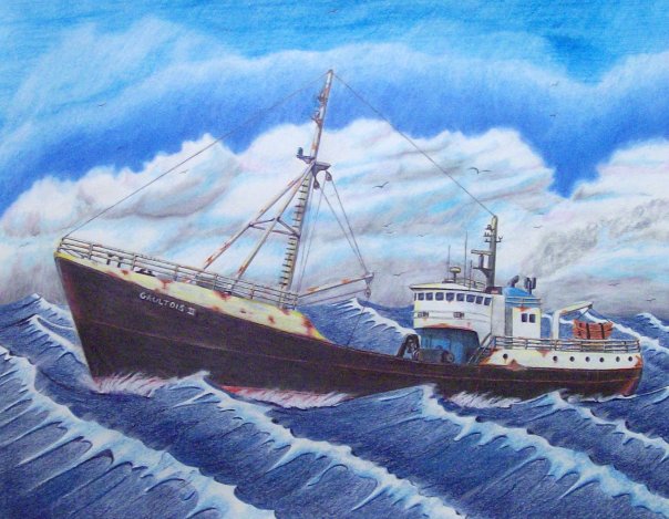
From there, she became Gaultois II, a name more firmly rooted in Newfoundland’s south coast fishing communities. Under that title, she worked through another chapter of Atlantic service, tying her history to outport life and the evolving offshore fishery. Only after these transformations — Blue Crest, Atlantic Mildred, Gaultois II — does the vessel emerge in her final and most recognized form: Matthew Atlantic.
To understand Matthew Atlantic is to understand the vessel that came before her — and the layered history carried forward in steel, registry numbers, and saltwater memory.
Only after understanding those earlier identities — Blue Crest, Atlantic Mildred, Gaultois II — can we arrive at Matthew Atlantic with clarity. In shipwreck research, names are more than labels; they are entry points. Each one marks a different era, a different crew, a different coastline. To tell the story properly, we begin at the beginning.
Forged in Steel — Pictou Shipyards
Before she was Blue Crest, before any crew signed aboard or nets were shot over her stern, the vessel began in steel and flame along the Northumberland Strait at Pictou Shipyard in Pictou, Nova Scotia. Founded in 1856 as the Pictou Iron Foundry by William Henry Davies, the yard evolved with the industry itself — from ironworks to full steel ship construction — adapting to the technological shifts that transformed maritime trade and fishing through the late 19th and early 20th centuries.
Ownership passed through generations and partnerships: the Davies family, then Joseph Robb and Douglas Hannon, and in 1906 to Allan A. Ferguson, who reorganized operations as the Pictou Foundry & Machine Company. After 1942, it operated as Ferguson Industries, a name closely associated with wartime production and post-war industrial shipbuilding. During the Second World War, the yard reached its peak, constructing 24 “Park” ships — Canadian-built cargo vessels such as SS Victoria Park — that formed part of the Allied merchant fleet lifeline across the Atlantic. In the decades that followed, the yard produced more than 100 post-war vessels, including trawlers, barges, and coastal working ships that would define maritime industry throughout Atlantic Canada.
By the time Blue Crest was laid down in 1964, she was emerging from a yard with deep industrial roots and wartime pedigree. The same slipways that had launched cargo ships for global conflict were now building steel trawlers for Newfoundland’s offshore fishery. The shipyard’s eventual bankruptcy in 1984 marked the end of an era, though the site continues under new ownership as Aecon Atlantic Industrial Inc., a reminder that maritime industry in Nova Scotia has always evolved rather than disappeared.
Understanding this builder context matters. Blue Crest — later Atlantic Mildred, Gaultois II, and ultimately Matthew Atlantic — was not a small craft of local origin. She was a product of one of Nova Scotia’s most historically significant industrial yards, built in steel by a company that had shaped wartime logistics and post-war Atlantic fisheries alike. Her story begins now.
The Offshore Machine — Blue Crest (1964–1968)
When she was launched in October 1964 as Blue Crest, the vessel entered service at a very specific moment in Newfoundland’s maritime history — the final surge of the large, company-owned offshore trawler era. Built at Ferguson Industries in Pictou, Nova Scotia, she measured approximately 130 feet in length and 331 gross tons, a steel-sided industrial fishing vessel designed for endurance and production rather than coastal convenience. She was not an inshore boat working within sight of land; she was built for the offshore grounds.
Her original owner, Job Brothers & Co., Limited of St. John’s, placed her squarely within one of Newfoundland’s historic mercantile fishing empires. Job Brothers had been operating since the 18th century and by the mid-20th century functioned as a vertically integrated enterprise — owning vessels, managing processing facilities, exporting fish, and supplying the very fleets that harvested the catch. A vessel like Blue Crest was part of that larger machine. She would have steamed to the Grand Banks or other offshore grounds, towed heavy trawl gear across cold Atlantic bottom, and returned with holds filled with cod and other groundfish destined for company plants and export markets.
Operationally, this places Blue Crest firmly within the industrial groundfish fishery. Her days would have revolved around setting and hauling nets, sorting catch on deck in harsh weather, icing or storing fish below, and turning back toward St. John’s when the holds were full. These were long trips in exposed waters — steel hull, working deck, winches straining under load — part of the demanding rhythm of offshore trawling in the 1960s.
Yet her service under that name was likely brief. By 1967, Job Brothers’ remaining St. John’s operations were shutting down amid consolidation and structural change within Newfoundland’s fishery. That timing aligns closely with Blue Crest’s name and ownership transition around 1968. Her identity as Blue Crest, therefore, represents both a beginning and an ending — launched during the last phase of Newfoundland’s traditional industrial fishing era, and renamed just as that world was beginning to close.
In tracing her as Blue Crest, we are not simply identifying an early name; we are placing the vessel inside a fading chapter of Atlantic maritime history — one defined by company fleets, offshore trawlers, and a fishery on the brink of profound transformation.
A Name Between Eras — Atlantic Mildred
The brief appearance of the name Atlantic Mildred in the vessel’s history likely reflects a transitional moment rather than a full operational reinvention. In commercial shipping and fisheries, interim renames commonly occur during ownership transfers, financing arrangements, corporate restructuring, or registry changes. The ship herself often continues working much as before — but on paper, she belongs to someone new.
While available records confirm that the name existed within the timeline between Blue Crest and Gaultois II, they do not clearly explain the reasoning behind it. What it suggests, however, is movement: a vessel shifting hands during the late 1960s, a period when Newfoundland’s fishing industry was consolidating and long-established firms were closing or restructuring.
In the broader narrative, Atlantic Mildred represents a hinge point — a short-lived identity marking the space between one era and the next. It is a reminder that ships, like the industries they serve, evolve through transition.
The South Coast Years — Gaultois II and Outport Industry
When the vessel became Gaultois II (Official Number 322298), she entered what would be one of the longest and most community-rooted chapters of her life. No longer tied to a St. John’s mercantile empire, she was now connected directly to the outport of Gaultois on the south coast of Newfoundland and Labrador. Here, the vessel was part of the working fleet that supplied the local fish plant — an operation originally established in 1952 by H.B. Clyde Lake and later known as Gaultois Fisheries. For decades, the plant was the economic heart of the town, and vessels like Gaultois II were its lifeblood.
The arrival of the vessel in Gaultois was remembered not simply as the addition of another fishing boat, but as a moment of genuine community pride. Nadine Northcotte, who grew up in the community, remembers sitting at the kitchen table with her parents while they talked about what the new vessel should be called. She wrote down one of the suggestions that evening — “Gaultois II.” When the ship finally arrived, the community gathered at the government wharf in numbers large enough to fill the shoreline. There was ceremony to mark the moment, including the traditional breaking of a bottle of champagne across the bow — a gesture that carried both celebration and hope. For a small outport whose economy revolved around the fish plant and the boats that supplied it, the arrival of a modern steel dragger was more than symbolic. It represented opportunity, stability, and the promise of work tied directly to the waters of Hermitage Bay.
As a dragger, she worked the surrounding fishing grounds of Hermitage Bay and the broader south coast — waters long known for productive bottom fisheries. Alongside sister vessels such as Hermitage, she targeted groundfish including cod and redfish, towing gear across the cold Atlantic floor and returning to unload directly into the processing system that sustained the community. This was not distant corporate fishing; it was regional industry, tied tightly to place and people.

Her years as Gaultois II spanned a dramatic period in Newfoundland’s fisheries history. The 1970s and 1980s marked both the height of the modern groundfish fleet and the early signs of strain that would ultimately lead to collapse. In that sense, the vessel represents more than a renamed trawler — she embodies the rise and decline of a generation of Newfoundland draggers. Through prosperous landings and tightening quotas, she remained part of a fleet that defined coastal working life on the south coast.
In tracing this era, we see the ship not simply as steel and registry numbers, but as a participant in community rhythm — steaming out of Gaultois harbour at first light, working the banks of Hermitage Bay, and returning to the plant that kept the town alive.
Landscape and Community — Gaultois
On the south coast of Newfoundland and Labrador, where the land fractures into coves and narrow fingers of rock, sits the isolated outport of Gaultois. There are no roads that lead here — only water and weather. The community clings to the edge of the Atlantic, its wooden homes rising from the shoreline on stilts, facing a harbour that has sustained generations of fishers, mariners, and boatbuilders.
Gaultois exists in rhythm with the sea. Fog rolls in without warning. Tides expose jagged rock and hidden shoals. In winter, storms sweep up from the southwest, driving heavy swell through the passages and testing both vessels and resolve. It is a place where seamanship is not romantic — it is necessary.
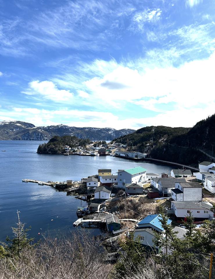
For more than a century, coastal steamers and supply vessels threaded these waters, connecting scattered outports to the rest of Newfoundland. Before highways and ferries reshaped transportation, ships were lifelines. Cargo, mail, livestock, and passengers all depended on captains willing to navigate the intricate coastline and its unforgiving reefs.
It is in this environment — remote, beautiful, and often unforgiving — that the deeper story of the Matthew Atlantic truly begins. Along Newfoundland’s south coast, the ocean has always been both provider and taker: sustaining communities through generations of fishing, while also claiming vessels when weather, timing, or fortune turned against them. Every harbour carries stories, and many of them rest beneath the surface.
In this case, however, the story does not begin with a sinking. As Gaultois II, the vessel did something different — she left. After years working the fisheries of Hermitage Bay and the south coast, she departed Newfoundland and made her way to Nova Scotia. That movement marked another turning point in her long identity shift, carrying with her decades of fishing history into new waters and a new chapter that would eventually lead to the name Matthew Atlantic.
Westward Again — Nova Scotia and the Birth of Matthew Atlantic
When the vessel left Newfoundland in the late 1980s, she entered a distinctly different phase of her working life. Acquired by Continental Seafoods of Shelburne, Nova Scotia, the 122-foot steel side trawler was purchased from a Newfoundland fish company during a period of restructuring within the Atlantic fishery. With the transfer came another identity change — she was renamed Matthew Atlantic, a name that would follow her into her final working decade.
Under Continental Seafoods, the vessel was converted from a traditional groundfish dragger into an offshore lobster boat, reflecting the economic realities of the time. By the late 1980s and early 1990s, the Atlantic groundfish industry was in steep decline, while lobster remained one of the few stable and lucrative fisheries. The conversion represented adaptation — not retirement. The steel hull that had once towed bottom gear on the south coast of Newfoundland was refitted to serve a new fishery along the coast of Nova Scotia.
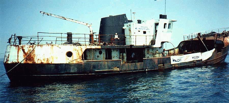
After her tenure with Continental Seafoods, the vessel changed hands again. Eventually, her working life came to a close, and rather than being scrapped, she was intentionally scuttled in August 1998 to create an artificial reef at Port Mouton, Nova Scotia — now part of what is commonly referred to as the Spectacle Marine Underwater Dive Park. There, the Matthew Atlantic rests on the sandy bottom, transformed once more — from industrial trawler, to lobster boat, to submerged structure supporting marine life and divers’ exploration.
In that final transformation, the vessel completed a full Atlantic arc: built in Nova Scotia, worked in Newfoundland, returned to Nova Scotia, and ultimately became part of the underwater landscape she had spent a lifetime navigating above.
Today, she rests on a sandy bottom in Port Mouton and has become a known local dive site—one of those rare cases where a working vessel’s “end” became a second life underwater.
A Planned Descent — The Scuttling — August 8, 1998
On August 8, 1998, at approximately 2:19 p.m., the Matthew Atlantic began her final descent — not as a casualty of storm or collision, but as part of a deliberate plan. Rather than explosives, her sinking was controlled and methodical: sea cocks were opened, allowing the Atlantic to reclaim the steel that had worked its waters for more than three decades. There was no violence in the act, only gravity and time. She settled upright on a sandy bottom, an intentional placement designed for stability and diver access.
The scuttling was a collaborative effort involving the Artificial Reef Society of Nova Scotia, the Region of Queens Municipality, and local stakeholders who saw value in giving the vessel a second life beneath the surface. Artificial reefs were becoming recognized not only as habitat generators, but as economic and recreational assets — drawing divers, supporting marine growth, and preserving working vessels in situ rather than reducing them to scrap.
Her resting place lies off Port Mouton, Nova Scotia, within what is commonly referred to as the Spectacle Marine Underwater Dive Park. Nautical charts mark the position clearly with a cautionary note: “Dive Site — Caution.” The wreck sits in approximately 60 feet (18 metres) of water, accessible to recreational divers yet deep enough to retain the atmosphere of a true Atlantic working ship.
Unlike so many vessels whose stories end abruptly, the Matthew Atlantic was given a structured farewell. She did not vanish; she was repositioned — transformed from trawler and lobster boat into artificial reef, from industrial asset into underwater landmark. In doing so, her story did not conclude. It simply shifted below the tide line.
Return — 2025
I first returned to the Matthew Atlantic in 2025, not simply as a diver, but while conducting sea trials with a newly built side scan sonar. The wreck is clearly marked on nautical charts off Port Mouton, and on this occasion the charted position proved reassuringly accurate. As I passed over the coordinates, the sonar screen lit up with the unmistakable profile of a large steel vessel — a strong return, elongated and defined, her structure casting a clear acoustic shadow across the sandy bottom.
Descending through roughly sixty feet of water, I found her resting not upright as originally placed, but on her port side, the starboard flank rising toward the surface. Time and Atlantic swell have shifted her slightly since 1998, but she remains largely intact. It is an easy descent, and the wreck lends itself to a full circuit on a single dive — bow to stern without haste.
Marine growth has claimed her in thick layers. Steel is no longer the dominant colour; instead, she wears the Atlantic. Plumose anemones cluster along railings and openings. Blue mussels and sea stars cling to exposed surfaces. Kelp and sea lettuce sway gently where sunlight reaches. Orange and white colonial tunicates spread across the hull plating, softening the hard industrial lines of what was once a working trawler. The wreck hums quietly with life — juvenile pollock weaving through openings, cunner holding tight to structure, the occasional lobster tucked into shadowed recesses. The artificial reef has become precisely what it was intended to be.
It was near the stern that something broke the natural pattern. A thick orange rope, clearly modern, rose from the seabed and drifted upward in a loose arc. It did not belong to the wreck. Following it down through the low swell, I found its source: a modern Danforth anchor, roughly two feet long and surprisingly heavy, resting partially embedded in the sand. Most likely it had been lost from a dive vessel — dropped to hold position over the wreck and never recovered.
I surfaced to retrieve a lift bag and reel. On the second descent, I secured the bag to the anchor, inflated it carefully until the weight became neutral, and began the controlled ascent. From there I swam back toward my boat, unwinding the reel behind me — laying a clear path that would later allow me to bring the anchor to my boat.
It was a small recovery, but fitting. The Matthew Atlantic had once hauled nets from the ocean floor. Now, resting quietly beneath the tide, she had given something back.
Because of the wind that afternoon, my boat had been moored carefully — one anchor line leading down across the wreck itself, and a second line running back to the boat to keep us positioned safely off the structure. The departure was planned deliberately. The idea was simple: maneuver the boat so both lines would clear cleanly, allowing us to recover my anchor line and then retrieve the newly discovered Danforth without fouling anything below.
Even the best-laid plans have a way of testing resolve.
As we repositioned and began hauling, it became clear almost immediately that something was wrong. The line attached to the recovered anchor would not rise. It came tight — solid, unmoving. Somewhere below, it had found purchase again. Whether on the wreck, debris, or contour in the sand, it was once more pinned to the bottom.
I am stubborn by nature. I could not leave it there. The sea had already claimed enough gear over the years.
So, I donned my dive gear again and followed the line back down. Then again. And then once more. Three dives to the Matthew Atlantic in a single day — each descent familiar now, the hull resting on her port side, marine growth drifting softly in the surge. On the final dive, I traced the snag to its hold, worked the tension free, and deliberately rerouted the line well clear of the wreck before ascending.
Back on the surface, we hauled steadily. This time the line rose cleanly. The anchor broke the surface beside the boat — heavy, mud-streaked, and finally ours again.
With both anchors aboard and the lines stowed, we pointed toward the dock at Port Mouton and headed in. Beneath us, the Matthew Atlantic returned to quiet, settled again into sand and tide — unchanged by our brief struggle above, but no less a part of the day’s story.
Plan Your Port Mouton Expedition
Getting There:
2-hour drive from Halifax via Highway 103 to Exit 21. Turn left on Port Mouton Connector Road, then right on Number 3 Highway. Continue left on Central Port Mouton Road, then left again on Central Port Mouton Breakwater Road to harbor access (15 min west of Liverpool).
Lodging & Dining:
- Port Mouton Bay Cottages & Restaurant
- Quarterdeck Resort, Summerville Centre
- White Point Beach Resort, Hunts Point
Diving:
- Bring your own boat or contact local fishermen at Port Mouton Harbour to arrange charters
- Primary: Matthew Atlantic artificial reef (43°54.146' N, 64°47.305' W | 60ft | west side island)
- Secondary: River Wye wreck (20-50ft | outboard side of Port Mouton Island | marine life hotspot) — see my full writeup: River Wye
Local Resources:
- Port Mouton Harbour Authority: 902-683-2555

Wreck Coordinates:
- Matthew Atlantic: 43°54.146' N, 64°47.305' W | 60 ft | Sand/Rock
- Boat Ramp: 43°55.135' N, 64°50.616' W
Vessel Specs: Matthew Atlantic — 331 GRT, 130 ft, Steel Hull
Modern survey technology—when paired with rigorous historical research and professional dive operations—continues to reveal and preserve the stories of vessels long thought lost to time and tide. The Port Mouton region stands ready to welcome the next generation of maritime explorers.
Dive Safety Notice: Professional dive operations are strongly recommended. Strong tidal currents, and challenging sea conditions require proper training, equipment, and local knowledge. These shared coordinates now guide future explorers, blending SCUBA with Nova Scotia's maritime heritage.
The confirmation of the River Wye's location represents a meaningful contribution to Atlantic Canada's maritime archaeology. The wreck's depth, proximity to Halifax, and well-documented historical record make it an exceptional site for future research, documentation, and recreational diving education. Modern survey technology—when paired with rigorous historical research and professional dive operations—continues to reveal and preserve the stories of vessels long thought lost to time and tide.
Ask me about the Highfield and Suzuki offshore expedition platform — engineered for serious divers.
#HighfieldHunter #HighfieldPatrol760 #SuzukiEngines #Suzuki-300hp #HalifaxShipwrecks #NSMaritimeHistory #NovaScotia#PortMouton #MatthewAtlantic
Dufferin Bell
Lost to Records: The Dufferin Bell
Highfield Hunter
Fog cloaks Framboise Cove's jagged shores on Cape Breton's southeast edge, where on May 13, 1951, a forgotten Park ship met its end. Framboise Cove nestles on Cape Breton Island's southeast coast, a rugged inlet where the Atlantic's relentless swell crashes against sheer granite cliffs and boulder-strewn beaches. Just 20 km south of Louisbourg's historic fortress, this remote corner feels worlds away—shrouded in fog half the year, with pounding surf that echoes the fury of countless storms.
Framboise Cove and Communities
Nearby Framboise village clings to the headlands, a tight-knit outpost of lobster fishers and summer folk whose roots trace to Acadian and Mi'kmaq heritage. To the north, Forchu's weathered homes overlook the cove, where locals still swap tales of salvage tugs like the Foundation Josephine racing from Louisbourg—too late to save the freighter. Note there are no dive shops or rentals in the immediate Framboise/Forchu area—plan gear transport accordingly.
Further north (~90 km via Hwy 104), Sydney provides full diver support with hotels, restaurants, and marine supplies as the ideal staging base for expeditions. This "forgotten fringe" of Cape Breton thrives on resilient communities—Richmond County's 8,000 souls blend fishing quotas, eco-tourism, and WWII echoes (nearby UXO dumps linger offshore). Between 1945 and the 1970s, it was common practice for ships to scuttle vast amounts of conventional explosives and chemical weapons (including mustard gas) in these waters.
Park Ships Era
As World War II gripped the globe in 1942, Canada's shipbuilding industry exploded from sleepy pre-war yards into a wartime juggernaut, churning out vessels to counter U-boat carnage in the Battle of the Atlantic. From just 38 ocean-going merchant ships in 1939, the nation ramped up to 57 yards and 38 berths by 1943, employing 57,000 workers—many women stepping into welding torches and rivet guns for the first time. The Park Steamship Company, formed April 8, 1942, spearheaded this effort, ordering 160+ bulk carriers and tankers modeled on Britain's simple North Sands design: no-frills freighters built fast and cheap. Positions in Pictou were created to enable shipbuilding with staff being relocated as required.
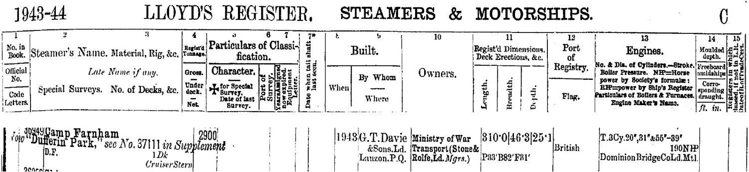
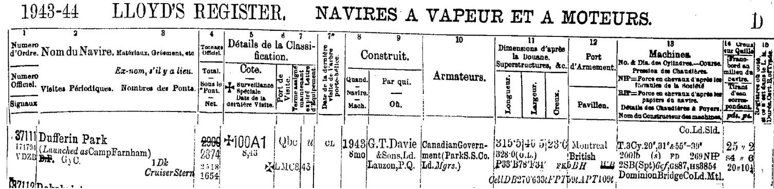
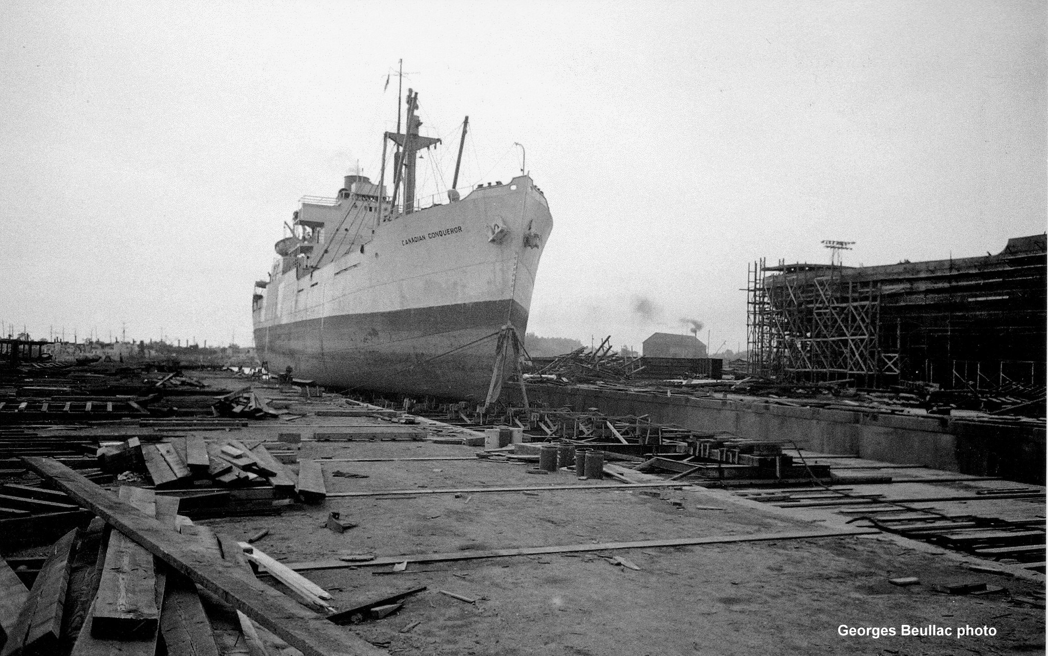
Enter the Park ships—176 coal-fired steamers (10,000 DWT class, plus smaller 4,700-tonners) named for Canadian parks like Gatineau or Point Pleasant, launched from yards in Pictou, Saint John, Montreal, and Davie Shipbuilding in Lauzon, Quebec. These 440-ft workhorses, with triple-expansion engines hitting 11 knots, hauled grain, timber, and munitions on 936 perilous voyages, some armed with bow guns and anti-torpedo nets manned by DEMS gunners. By 1945, Canada's yards had birthed 436 merchant ships under government contracts, transforming a peacetime coastal trade nation into an Allied lifeline—yet postwar surplus doomed most to scrap or sale abroad. Dufferin Bell, birthed in this frenzy at Davie Shipbuilding & Repairing Co. in Lauzon, Quebec, embodies the era's grit: rushed to sea as Camp Farnham (later Dufferin Park), renamed for commerce, and bound for obscurity in Framboise Cove.
Canada's wartime shipbuilding demanded total national commitment, with government campaigns urging every citizen to contribute to the war effort against Axis threats. Factories and yards became symbols of unity, where skilled tradesmen worked alongside novices in round-the-clock shifts to meet impossible deadlines. Women played pivotal roles, breaking barriers as welders, riveters, crane operators, and electricians—thousands entering the workforce for the first time, their hands on torches forging the hulls that sustained Allied convoys. This collective sacrifice turned sleepy shipyards into arsenals of freedom, producing vessels like Park ships in record time despite material shortages and blackout drills.
Launched as Camp Farnham amid 1943 urgency, renamed Dufferin Park to join her sisters—then Dufferin Bell for Maritimes trade.
SS Dufferin Bell
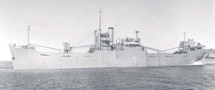
Launched as a standard Park ship "4700-tonner," SS Dufferin Bell measured 441 feet in length overall (LOA), with a 56.5-foot beam, 34.5-foot depth, and 2,874 gross register tons (4,719 deadweight tons). Her coal-fired triple-expansion steam engine delivered 475 nominal horsepower to a single screw propeller, pushing the freighter to 11 knots on efficient coastal runs. Three derrick-equipped masts served five cargo holds optimized for grain, timber, or bulk—self-unloading design that defined her postwar trade. By 1951, wartime bow gun mounts were long gone, leaving a utilitarian hull stripped for commerce, vulnerable without DEMS defenses when fog turned Framboise's ledges lethal. Today, divers find her flattened boilers, winches, and shaftline echoing that robust wartime blueprint amid the scatter.
There were 43 of the 4700-tonner ships built, 24 of (over half- built in Pictou, Nova Scotia) some with many name changes and use post war, others did not survive the war. Those known to have wrecked include:
| Wartime Name | Postwar Name(s)/Fate |
| Avondale Park | Sunk by U-boat 1945 |
| Beresford Park | Federal Ambassador → Gerda Toft (sank 1954) |
| Crescent Park | Julia → Lona → Senator Hagelstein → Agia Sophia → Manos Lemos (wrecked 1969) |
| Dufferin Park | Dufferin Bell (wrecked 1951 Framboise Cove) |
| Kensington Park | Docteur Yersin (wrecked 1953) |
| Lansdowne Park | Caribbean Trader (wrecked 1963) |
| Montmorency Park | Docteur Angier (wrecked 1949) |
| Taber Park | (sunk 1945 U-boat) |
| Taronga Park | Merian (wrecked 1977) |
| Victoria Park | (Torpedoed 1945; Pictou lead ship) |
| Wentworth Park | Azar (wrecked 1968) |
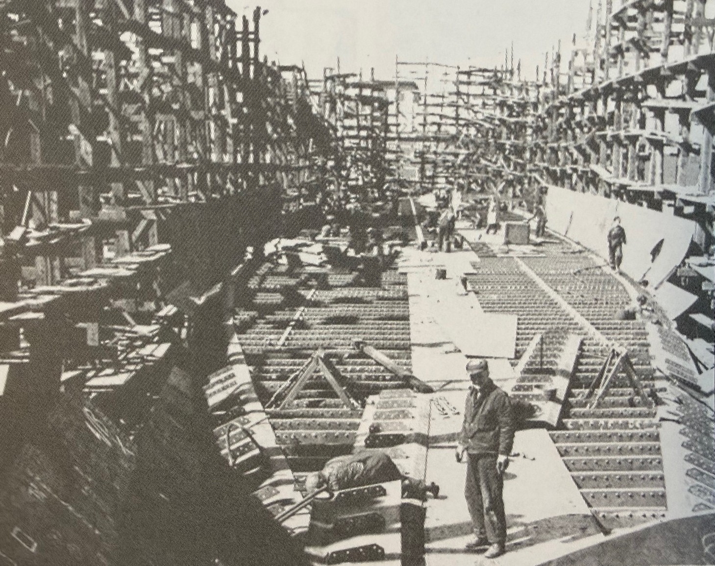
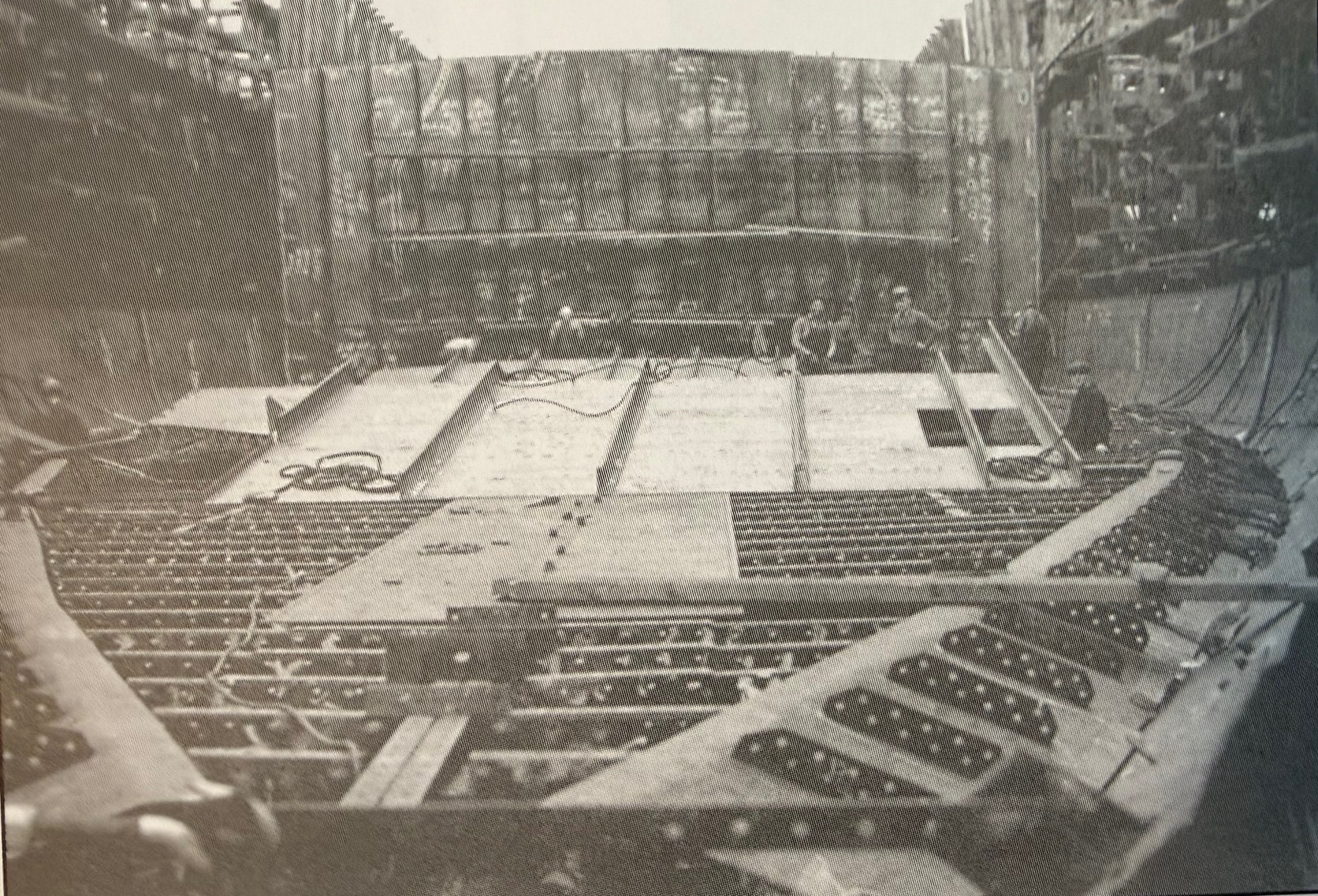
While no photos of SS Dufferin Bell exist, the following photos depict ships from the same Modified Scandinavian-class Park ships (4,700 DWT), conveying the compact size (~420 ft LOA) that helps readers visualize her vast, scattered wreckage in Framboise Cove's shallows.
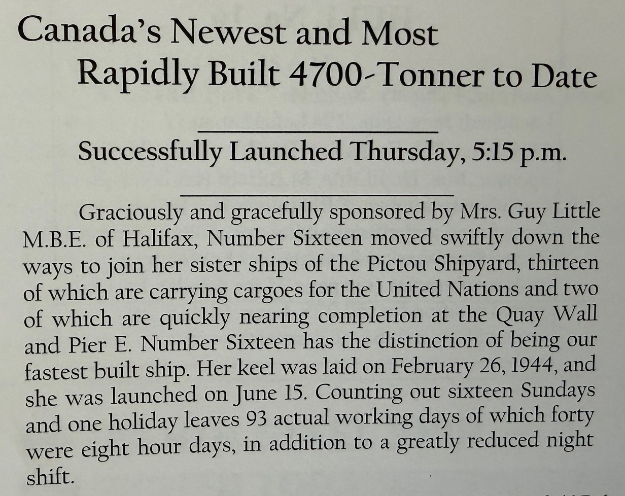
To meet the wartime effort, these ships were built in record time. Articles at the time confirmed the incredible speed and effort that was required. Ships were recorded as being completed in under 4 months from the keel being laid to launching.
Service History
Detailed voyage records for SS Dufferin Bell (ex-Camp Farnham/Dufferin Park) are scarce, typical for "workhorse" Park ships whose logs faded postwar—fueling the "lost to records" allure. Launched amid 1943 urgency, she likely convoyed bulk cargoes like grain, timber, or ore across the North Atlantic, dodging U-boats with DEMS gunners and zigzags en route to UK/Mediterranean ports. Managed by Pickford & Black Ltd. for Park Steamship Co. (Montreal), her wartime service mirrored sisters: essential supply runs sustaining Allied armies, possibly Halifax-to-Liverpool hauls amid vital North Atlantic convoys.
Post-VE Day (1945), sold 1946 to Picbel Ltd. (Halifax), she shifted to coastal peacetime trade—her final leg from Saint John, NB, to Louisbourg, NS, laden unknown, perhaps gypsum or fish meal common to Maritimes freighters. No crew manifests or logs surface publicly; Lloyd's/Wrecksite note only the May 1951 end, suggesting routine runs until fog claimed her at Framboise. This opacity echoes Park fleet's fate—hundreds scrapped, histories buried like her hull.
The Wreck Climax
As dusk settled over Framboise Cove on May 13, 1951, the Dufferin Bell was already in trouble. The 2,874-ton freighter had crept in toward Cape Breton’s southeast coast on a coastal leg from Saint John to Louisbourg, trading the open Atlantic for a deceptively tight approach along a lee shore. In fog or low visibility—routine on that coast in spring—she found rock instead of safe water, driving hard aground on the cove’s outer ledges. Steel on stone would have been audible for miles: a long, grinding shudder as frames twisted and plates opened to the sea.
Once stranded, the ship’s fate shifted from navigation to survival and salvage. With no loss of life reported, the crew’s first battle was simply to get off safely—boats over the side, lines rigged to the shore, and a cold, wet scramble onto the rocks while the hull worked under them. Messages went out for assistance, and within days a tug—likely one of the Foundation fleet working out of Halifax and Louisbourg—arrived to try to pull her free. But a Park ship’s deep, boxy hull wedged onto a rising and falling swell is a stubborn thing; every tide and wave only set her higher on the jagged bottom.
The more the Atlantic pounded her, the more the Dufferin Bell ceased to be a ship and became a wreck. Bulkheads buckled, cargo shifted, and any hope of refloating her slipped away as surveyors and insurers weighed the cost of salvage against her residual value in a market already flooded with surplus wartime tonnage. In the end, she was written off where she lay, a total constructive loss on a remote Cape Breton shore. The Park ship that had survived the Battle of the Atlantic was finally undone not by a torpedo, but by a foggy approach, a hard rock ledge, and a coastline that has claimed vessels for centuries—leaving her story, and even her captain’s name, largely lost to record.
Diving the Wreck
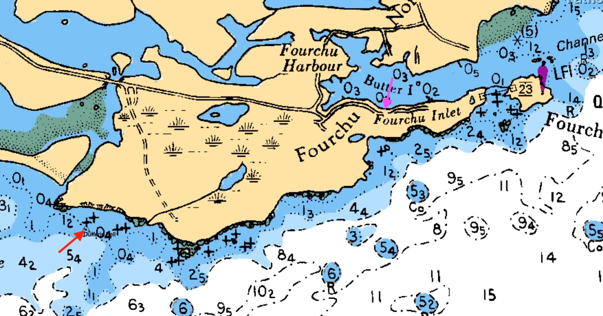
My last dive on the Dufferin Bell wreck came in August 2025, a rare calm day on Framboise Cove's treacherous ledges where the old Park ship lies scattered like shrapnel from an exploded can of pop. Pinpointing the shaftline at 45°42.251' N, 60°17.620' W—flattened against the ocean floor amid a debris field of twisted plates and recognizable fittings—felt like victory after the site's usual "washing machine" chaos. Proximity to shore amplifies every swell, cliffs funneling waves into a violent churn; only slack tide or glass-flat seas make it diveable, rewarding patience with intact boilers, winches, and propeller remnants still identifiable after 74 years underwater.
Launch from the unmarked slip on St. Peters-Forchu Extension Road demands local savvy—no tie-ups, just a rough concrete ramp hugging Forchu Inlet's edge, with gravel shores and minimal amenities. Visibility hovered 10-20 ft that day, schools of fish parting as we finned amid the wreckage, magnetometer pings from prior SeaSpy hunts confirming the spread. It's raw Cape Breton diving: no crowds, big currents if mistimed, but artifacts whisper of wartime grit—perhaps a forgotten valve or gauge from her Davie yard days can still be viewed.
Access Details
The boat slip for accessing Dufferin Bell is precisely at 45°42.953' N, 60°14.977' W, an unmarked gravel pull-off on the St. Peters-Forchu Extension Road (Route 320) along Forchu Inlet's western shore. This rough concrete ramp—visible as weathered slab amid kelp-fringed gravel—offers no dock, cleats, or amenities; beach small rigid-hulls like your Highfield Patrol at mid-to-high tide to dodge mudflats.
From here, motor ~2-3 km southeast to wreck coords (45°42.251' N, 60°17.620' W), eyeing CHS Chart 4417 for the "false passage" reef that vanishes at high water—stay offshore or risk grounding like the Bell herself. Local knowledge rules; no facilities mean pack fuel, gear, and comms for this remote Cape Breton launch. For fellow wreck hunters, mark calm forecasts, rig reef lines, and launch early; this one's a diver's puzzle, pieced from chaos.
Plan Your Forchu Expedition
Getting There:
5-hour drive from Halifax via Highway 102 to Truro, then off the ramp to the right towards Cape Breton Island. Continue Highway 104 through New Glasgow and Antigonish to the Canso Causeway. Cross the Canso Causeway and head southeast via Highway 320 toward St. Peter’s, then local roads (route 320/247) to Forchu/Forchu Harbour. Be cognisant of the narrower roads toward the end of the trip. Amenities including fuel are scare on the local roads.
Alternately, once arriving at Canso Causeway, travel towards Sydney over Kelly’s Mountain and in towards Marion Bridge. Modern GPS have lots of support.
Lodging & Dining:
Forchu has no hotels, inn, restaurants or stores. Alternates include
- Peck’s Cottages in Lousibourg
- Modern hotels in Sydney
Diving:
- Bring your own boat or contact local fishermen at Forchu to arrange charters
- Primary: Dufferin Bell (45°42.251' N, 60°17.620' W )
- Secondary: Yet to be determined, but area has other wrecks yet unfound.
Local Resources:
Forchu has no listed Harbour Authority Contact. The harbour operates through a lease agreement with Small Craft Harbours, a branch of Fisheries and Oceans Canada (DFO).

Legacy
The Dufferin Bell endures as a shattered testament to Cape Breton's unforgiving coast and Canada's wartime shipbuilding legacy—a Park ship born in frenzy, lost to fog and rock, her captain's name and full voyages faded like hull plates under kelp. From Davie's Lauzon ways to Framboise Cove's debris field, she whispers of U-boat dodges, postwar scrambles, and the raw Atlantic that claimed her on that fateful May day in 1951.
Yet in her scattered remnants—boilers, winches, shaftline at 45°42.251' N, 60°17.620' W—lies a diver's goldmine of artifacts to see and identify, but to leave untouched, accessible from Forchu's unmarked slip (45°42.953' N, 60°14.977' W) on calm days when the "washing machine" relents. For wreck hunters, she's prime for rediscovery: a puzzle of recognizable artifacts amid cod runs and currents, fueling NS maritime tourism one dive at a time.
Lost to records? Perhaps—but not to those who fin through her chaos. Mark the tides, dodge false passages, and let her story surface for the next generation of explorers.
Wreck Coordinates:
Dufferin Bell: 45°42.251' N, 60°17.620' | 20-40 ft | Sand/Rock
Boat Ramp: 45°42.953' N, 60°14.977' W
Vessel Specs: Dufferin Bell — 2874 GRT, 440 ft × 57 ft, Steel Hull
Modern survey technology—when paired with rigorous historical research and professional dive operations—continues to reveal and preserve the stories of vessels long thought lost to time and tide. The Forchu region stands ready to welcome the next generation of maritime explorers.
Dive Safety Notice:
Professional dive operations are strongly recommended. Strong tidal currents, and challenging sea conditions require proper training, equipment, and local knowledge. These shared coordinates now guide future explorers, blending SCUBA with Nova Scotia's maritime heritage.
The confirmation of the Dufferin Bell’s location represents a meaningful contribution to Atlantic Canada's maritime archaeology. The wreck's depth and documented historical record make it an exceptional site for future research, documentation, and recreational diving education. Modern survey technology—when paired with rigorous historical research and professional dive operations—continues to reveal and preserve the stories of vessels long thought lost to time and tide.
Ask me about the Highfield and Suzuki offshore expedition platform — engineered for serious divers.
#HighfieldHunter #HighfieldPatrol760 #SuzukiEngines #Suzuki-300hp #HalifaxShipwrecks #NSMaritimeHistory #DufferinBell #NovaScotia #CapeBretonIsland #DufferinBell

River Wye
The Tragic Fogbound End of the River Wye: A Nova Scotia Shipwreck Tale
Highfield Hunter
In the grey dawn of November 24, 1923, the British cargo steamer River Wye—a weathered survivor of World War I's brutal seas—met its end on the jagged rocks off Port Mouton Island, Nova Scotia. What began as a routine coal run from Saint John, New Brunswick, to Boston turned into a harrowing tale of fog, mis-navigation, and narrow escape, etching the ship's story into Atlantic Canada's maritime lore.
From Teesside Shipyard to Tramp Trader
Launched in 1906 as SS Glamorgan by Craig, Taylor & Co. Ltd. at their Thornaby-on-Tees yard on England's River Tees, the 3,576 GRT steel steamer measured 342 feet long with a 51-foot beam. Built for Jenkins Bros. of Cardiff (yard #~140), she was renamed River Wye later in her career. The yard, founded in 1885 amid Teesside's industrial boom, specialized in versatile tramps and colliers, producing over 300 vessels before closing in 1931 due to the Great Depression.
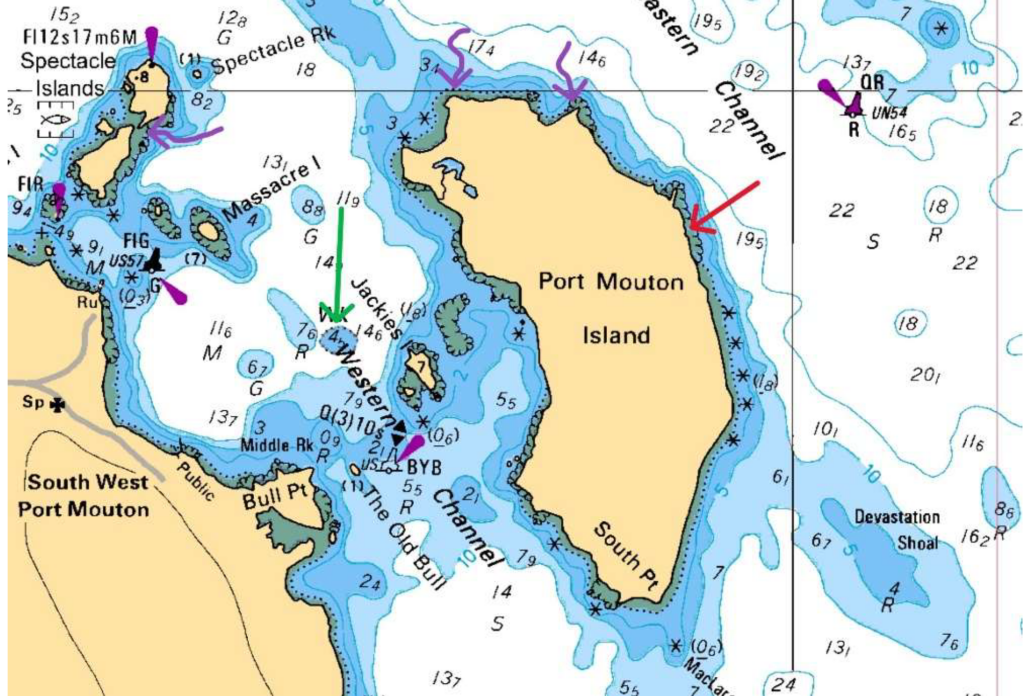
features, depth contours (5-22 meters shown), and marked wrecks (River Wye (red) and Matthew Atlantic (green, also
three potential wrecks (purple)). The stranding location aligns with charted shallow water and rocky hazards that claimed
the River Wye in 1923.
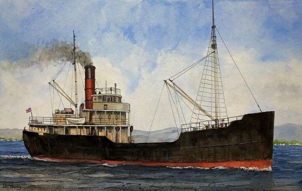
characteristic single red funnel, two-mast configuration, black hull with red anti-fouling bottom, and steel construction.
This vessel type exemplifies the tramp steamer design that defined River Wye's class and operational profile
River Wye embodied the era's tramp steamer life: shuttling coal from UK ports to South America, the Mediterranean, and North American grain/coal trades. Owned by Llewellyn, Merrett & Price of Cardiff—which managed the vessel through the post-WWI era—she passed hands following the decline of the traditional tramp steamer trade. No major incidents marred her record until that fateful 1923 voyage.
The Final Voyage: Fog's Deadly Deception
On November 22, Captain David Williams departed Swansea (UK) with 27 crew, loaded with coal for Boston (US). Fog rolled in thick off Nova Scotia's south shore, a notorious hazard for coastal shipping. From a prior fix at 44°46'N, 61°21'W, the ship steered S. 62° W at 7.5 knots, but without celestial sights, their position unraveled.
At ~6:15 a.m. on the 24th, lookout David Evans peered into the murk—visibility under 14 ship lengths (~250 yards)—and saw nothing until the crunch of rocks at Port Mouton Island (initial reports: 44°00'N 64°20'W). The ship stranded near the island amid stormy seas, becoming a total constructive loss valued at £40,000. Remarkably, no lives were lost; all hands abandoned ship and were rescued by the local Port Mouton residents.
official notification of the vessel's stranding near Port Mouton Island and rescue of the crew.
Customs House, November 30, 1923, under Dominion Wreck Commissioner Capt. L.A. Demers, F.R.A.S
Precise Wreck Location and Accessibility
Updated coordinates pinpoint the site at 43°54.487' N, 64°45.418' W (decimal: 43.9081° N, 64.7570° W), off the island's east coast amid rocky ledges in 20-50 feet of water—ideal for recreational diving from Halifax, just a two-hour drive (~150 km southwest). This nearshore spot aligns with Port Mouton's nautical charts and local 1923 stranding records.
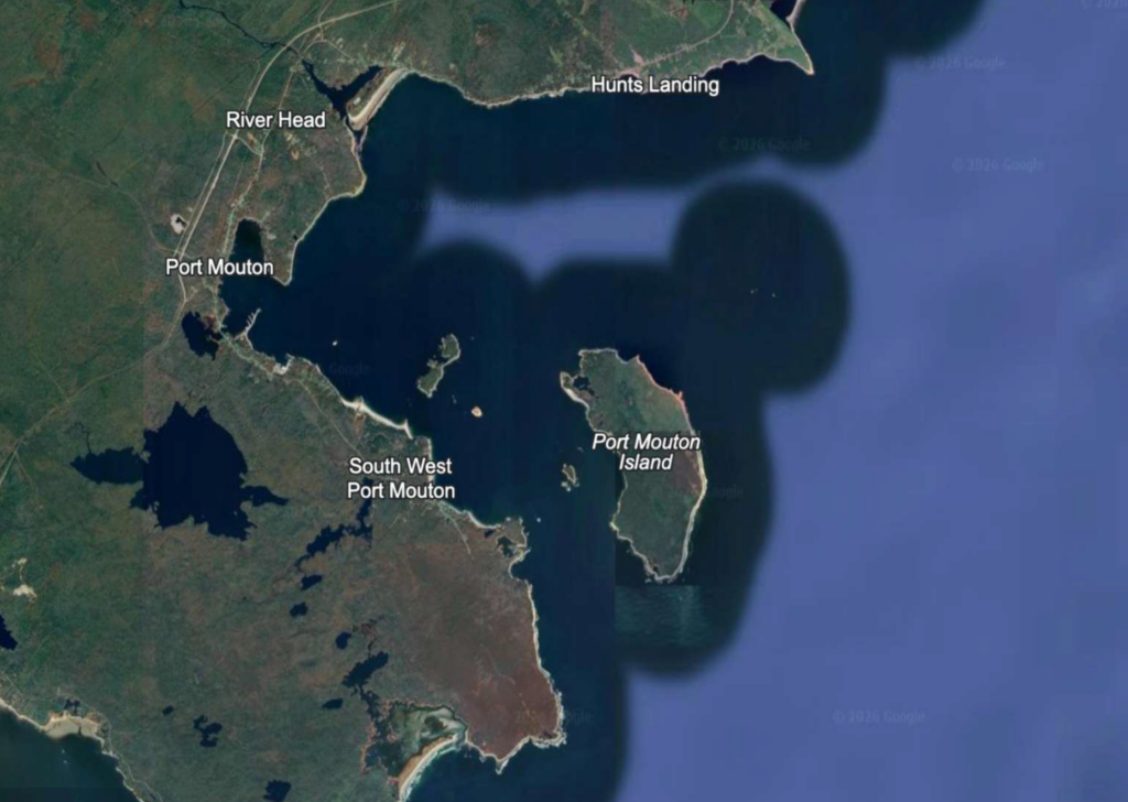
Point, Hunts Landing, River Head, and Port Mouton settlement. The wreck site coordinates (43°54.487'N, 64°45.418'W)
place the River Wye wreck off the island's east side amid rocky outcrops and shallow waters.
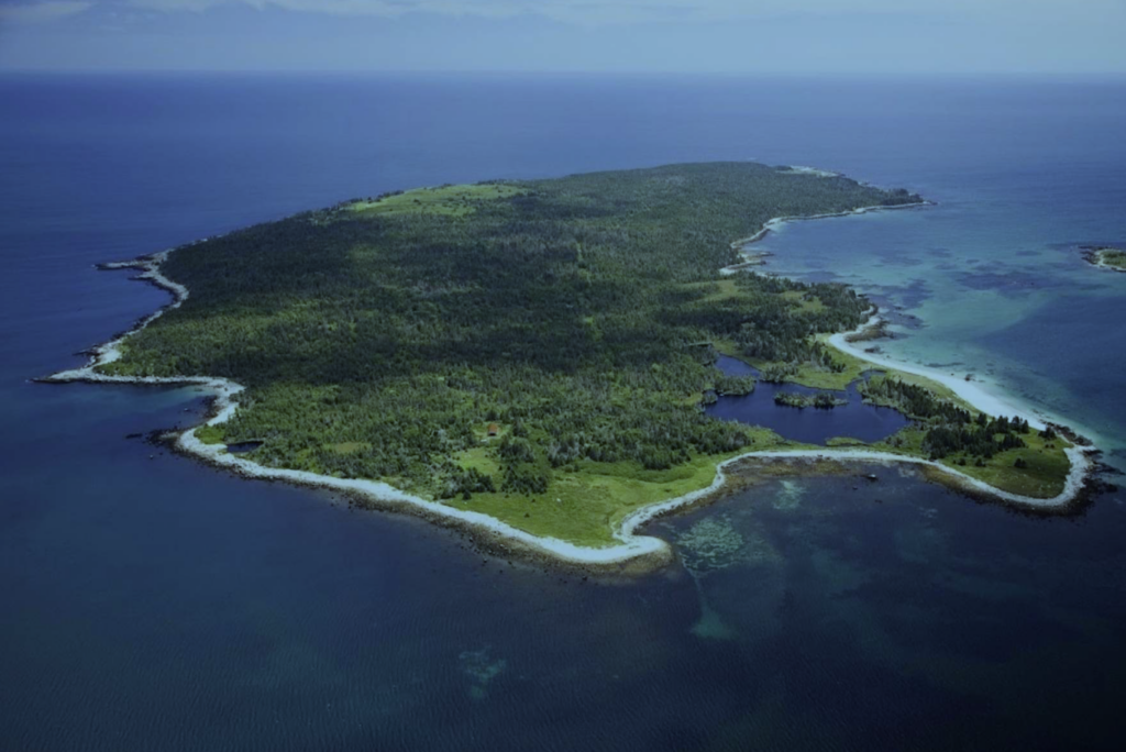
River Wye stranded on the eastern side (left side of photo. The rocky ledges and shallow offshore waters visible in this
image match the hazardous conditions documented in the 1923 inquiry records.
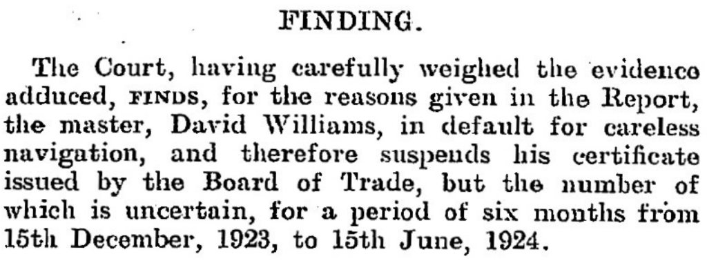
The Halifax Inquiry: Blame on the Bridge
The formal investigation (No. 7804) conducted November 30, 1923, at Halifax Customs House under Dominion Wreck Commissioner Capt. L.A. Demers, F.R.A.S., with Assessors Capt. T.R. Coffin and Capt. Neil Hall. Witnesses—Master David Williams, 2nd Engineer G.J. Humphrey, 2nd Officer J.E. Herbert, 1st Officer R. Jones, wheelsman J.T. Garnett, and lookout David Evans—detailed the haze post-unreliable noon fix (44°46'N 61°21'W) and single Sambro Light bearing. The Court condemned Williams' "indifference and neglect" for skipping soundings, Chebucto Head wireless bearings, or fixes despite SE winds; Herbert was censured for poor lookout amid visibility disputes (4-5 miles claimed vs. Evans' 1 shiplength). Williams' certificate was suspended 6 months (Dec 15, 1923–Jun 15, 1924); others mostly exonerated. The verdict highlighted the River Wye (3,576 GRT, Official No. 123170; Swansea to Boston) as lost to careless navigation on a prudent coast.
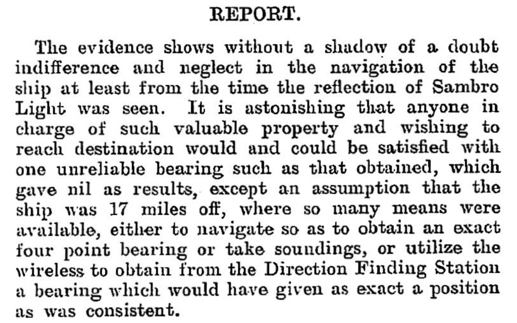
Port Mouton, a rugged outpost on Nova Scotia's "Gravely Coast," claims another chapter in the province's 20th-century wreck tally. River Wye's story endures as a cautionary saga of human error against nature's veil—her bones a potential gem for local maritime research.
Modern Rediscovery: Pinpointing with Side-Scan Sonar
Fast-forward a century: though previously dove, the wreck's precise coordinates were elusive until August 31, 2025, when—operating from my Highfield Patrol 760—I towed side-scan sonar across promising sections near Port Mouton Island. The Patrol 760 handled the towing configuration flawlessly, maintaining stable positioning even in choppy tidal currents, while high-resolution acoustic imaging revealed a distinctive "feather-like" shadow.
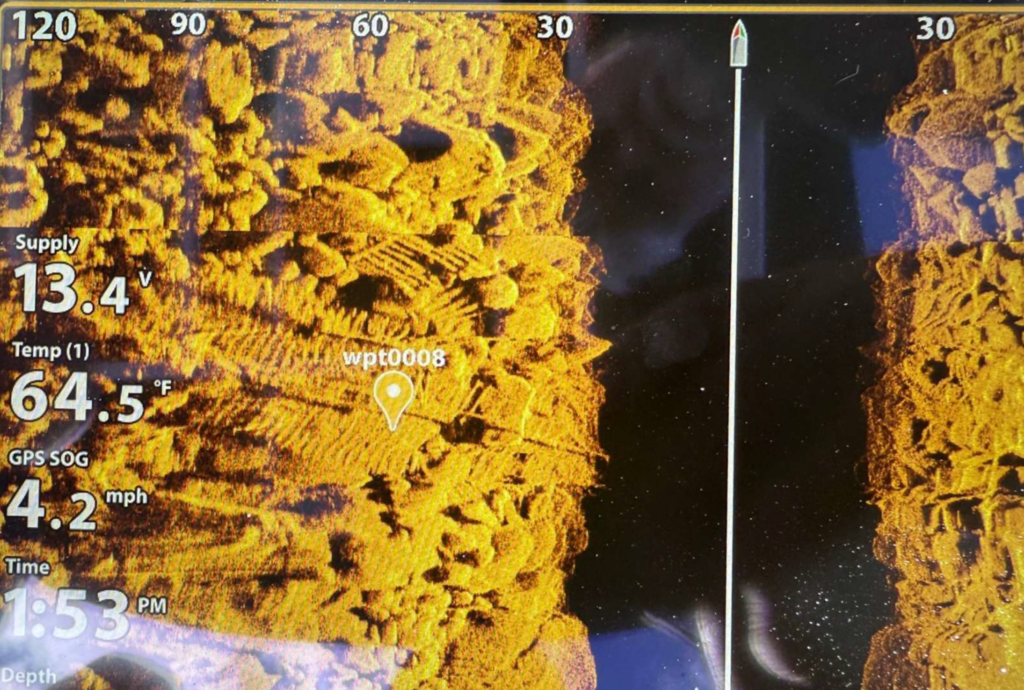
hull structure. The high-resolution sonar data clearly reveals the exposed ribs and framing of the steamer wreck. Waypoint
wpt0008 marks the sonar contact at coordinates 43°54.487'N, 64°45.418'W. The sonar target display shows supply voltage
13.4V, temperature reading 64.5°F, and GPS speed-over-ground of 4.2 mph, documenting the precise survey conditions.
Depth indicator: approximately 30 feet.
This methodical survey paid off with the shipwreck finding, validated by subsequent diving; Highfield's rugged aluminum design proved essential to this breakthrough, enabling precise gear deployment where lesser boats would struggle. Today, the wreck features lots of wreckage to explore including a 120-foot shaftline precariously spanning large boulders, offering recreational divers a thrilling swim-under passage.
Experience Maritime Nova Scotia: Legacy & Discovery
The River Wye rests in 20-50 feet of Atlantic waters—accessible yet challenging—a time capsule of Edwardian maritime tragedy. Port Mouton Island represents everything Atlantic Canada offers: rugged coastline, fishing heritage, protected harbors, and underwater archaeology. The River Wye discovery showcases modern survey capability meeting historical passion—available now to divers, researchers, and maritime enthusiasts.
From Highfield's aluminum hull weathering choppy seas to local fishing charters supporting certified divers, the region's economy has access and adventure. The 988-acre island's white-sand beaches and wooded trails complement world-class wreck diving. Port Mouton is considered the largest private island on the east coast. This shallow wreck exemplifies Nova Scotia's untapped maritime potential: dozens more lie undocumented along the south shore, waiting for the next generation of Highfield Hunters. Your dive could be the next rediscovery.
Plan Your Port Mouton Expedition
Getting There: 2-hour drive from Halifax via Highway 103 to Exit 21. Turn left on Port Mouton Connector Road, then right on Number 3 Highway. Continue left on Central Port Mouton Road, then left again on Central Port Mouton Breakwater Road to harbor access (15 min west of Liverpool).
Lodging & Dining:
- Port Mouton Bay Cottages & Restaurant
- Quarterdeck Resort, Summerville Centre
- White Point Beach Resort, Hunts Point
Diving:
- Bring your own boat or contact local fishermen at Port Mouton Harbour to arrange charters
- Primary: River Wye (43°54.487' N, 64°45.418' W | 20-50ft | east side island)
- Secondary: Matthew Atlantic artificial reef (~60ft | inboard side of Port Mouton Island | marine life hotspot)
Local Resources:
- Port Mouton Harbour Authority: 902-683-2555
Wreck Coordinates:
- River Wye: 43°54.487' N, 64°45.418' W | 20-50 ft | Sand/Rock
- Boat Ramp: 43°55.135' N, 64°50.616' W
Vessel Specs: River Wye — 3,576 GRT, 342 ft × 51 ft, Steel Hull, 120-ft Shaftline
Modern survey technology—when paired with rigorous historical research and professional dive operations—continues to reveal and preserve the stories of vessels long thought lost to time and tide. The Port Mouton region stands ready to welcome the next generation of maritime explorers.
Dive Safety Notice: Professional dive operations are strongly recommended. Strong tidal currents and challenging sea conditions require proper training, equipment, and local knowledge. These shared coordinates now guide future explorers, blending SCUBA with Nova Scotia's maritime heritage.
The confirmation of the River Wye's location represents a meaningful contribution to Atlantic Canada's maritime archaeology. The wreck's depth, proximity to Halifax, and well-documented historical record make it an exceptional site for future research, documentation, and recreational diving education. Modern survey technology—when paired with rigorous historical research and professional dive operations—continues to reveal and preserve the stories of vessels long thought lost to time and tide.
Mentioned In