
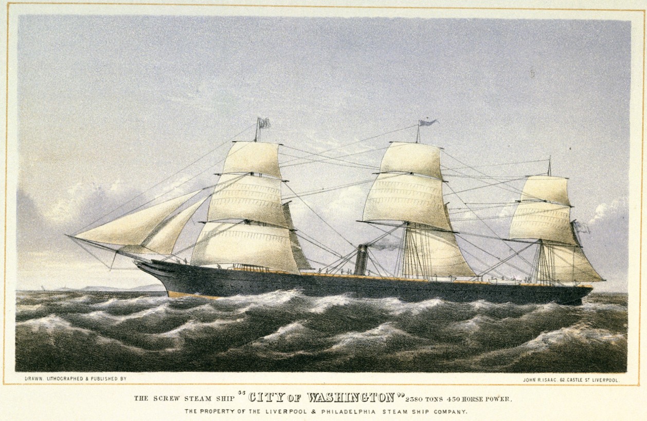
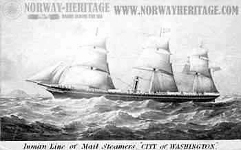
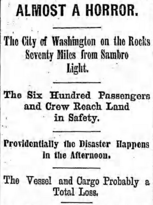
City of Washington
Into the Fog: The Loss of the City of Washington
Highfield Hunter
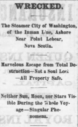
South Coast of Nova Scotia – July 5, 1873
The fog was so thick that afternoon that the sea seemed to end only a few yards from the ship.
For days, the passengers aboard the steamship City of Washington had lived with the sound of the fog-horn—its hollow note echoing out into the Atlantic, marking time in a place where nothing else could be seen. The voyage had settled into rhythm: engines turning steadily beneath the deck, conversations in the saloon, emigrants gathering where they could find air above.
Beyond the rail, there was nothing.
The horizon had vanished. The sky and sea had merged into a single grey field.
Shortly after half past one, that routine ended.
There came a sudden jolt beneath the hull.
Passengers felt two light bumps—then a violent shudder, longer this time, as iron scraped against rock. The entire ship trembled.
The City of Washington had run full speed onto Gull Rock Shoal, along the coast of Nova Scotia.
No one aboard knew it yet.
The fog still held.
The System Behind the Voyage
By the time the City of Washington pushed west into that fog, she was part of a much larger system.
The North Atlantic had become a corridor—of movement, of industry, of departure. Steam power had transformed ocean travel. Where sail had once meant uncertainty, steam promised schedule.
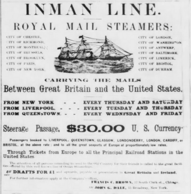
Companies like the Inman Line built their reputation on that promise.
Their ships carried more than cargo. They carried people in motion—families leaving Ireland, labourers from Britain, tradesmen from across Europe. Above them travelled cabin passengers with means. Below, hundreds crossed in steerage, bound by destination rather than circumstance.
All of them shared the same ocean.
And the same risks.
The Ship – Built for the Crossing
Built in 1855 at Glasgow, the City of Washington belonged to a transitional generation of ocean vessels.
She was an iron-hulled screw steamer—over 300 feet in length—combining steam propulsion with a full sailing rig. It was a design born of uncertainty. Steam was advancing, but not yet trusted on its own.
Inside, the divisions of the era were clear.
Cabin passengers occupied the central saloon spaces. Forward and aft, steerage compartments carried hundreds of emigrants. On her final voyage, she held:
- 28 cabin passengers
- More than 480 in steerage
- Nearly 100 officers and crew
Below them lay cargo typical of an industrial age—steel rails, iron bundles, manufactured goods bound for American expansion.
She had made this crossing for nearly two decades.
Nothing about this voyage suggested it would be different.
For nearly two decades, she had moved back and forth across the Atlantic, part of a system that depended on repetition. Departures, crossings, arrivals—measured not in individual voyages, but in schedules kept and routes maintained. Ships like the City of Washington were not exceptional. They were expected to work.
And that expectation shaped how they were navigated.
The ocean was not unknown—but it was not forgiving. Precision mattered, but so did confidence. Masters were expected to keep time, to make landfall when expected, to move through conditions that could not always be seen or measured.
It was within that balance—between certainty and assumption—that small errors could begin.
The Voyage – Into the Grey
She left Liverpool on 24 June 1873.
At Queenstown, more passengers boarded before the ship turned west into the Atlantic.
Then the fog came.
Not briefly. Not in passing.
It settled—and remained.
Day after day, the sky was hidden. Without sun or stars, navigation shifted to estimation. Position was no longer measured—it was believed.
Speed. Heading. Time.
Dead reckoning.
For short periods, it worked. Over days, small uncertainties accumulated.
Still, the ship maintained speed.
Still, the fog-horn sounded.
Still, the passengers waited.
And somewhere on deck, they leaned into the rail, staring into the grey—believing there was nothing there.
What they could not see was not empty water.
It was distance closing.
The Nova Scotia Coast
For days, the ship had moved without a confirmed position.
Only two celestial observations had been taken early in the voyage. After that, the fog held. Without sun or stars, navigation relied entirely on estimation—course, speed, and time carried forward without correction.
No soundings were taken as the vessel approached North America.
The crew believed they were farther south.
They were not.
The coast of Nova Scotia does not announce itself.
It waits.
Reefs and shoals extend outward beneath the surface, hidden by fog that can reduce visibility to nothing. Only months earlier, the liner Atlantic had been lost along the same coast with heavy loss of life.
But on 5 July, the passengers aboard the City of Washington believed themselves far from danger.
Inside, the engines turned steadily.
Then the ship struck.
The Impact
The grounding came without warning.
The vessel drove onto Gull Rock Shoal, less than half a mile from shore—though no one aboard could see it. Confusion spread quickly. Some believed they had struck offshore banks. Others admitted they did not know where they were.
In reality, land lay just beyond the fog.
And help was closer than anyone realized.
The Rescue at Port Le Bear
At first, there was only silence.
The fog-horn sounded. Signal guns were fired.
Then—unexpectedly—a reply.
A voice.
Through the mist, a small boat appeared, carrying two local fishermen—Cornelius Swanburg and William Ferguson. They had heard the signals and made their way out to the stranded liner.
“Where are we?” came the question from the deck.
“Off the coast of Nova Scotia.”
“How far from land?”
“Half a mile.”
Relief spread immediately.
Moments earlier, many aboard had believed themselves still far out in the Atlantic—days from land, beyond immediate help. The realization that shore lay within reach changed everything. What had been uncertainty became urgency.
Now, the task was not survival at sea—but getting everyone off the ship before conditions changed.
Evacuation began at once. Lifeboats were lowered, and order was maintained under strict control. Women and children were sent first. Despite the circumstances, passengers remained disciplined.
Within three hours, every person aboard had been landed safely on shore.
Refuge on the Shore
The small community at Port Le Bear absorbed the survivors as best it could.
Cabin passengers were taken into homes. Steerage passengers and crew gathered along the shoreline, where fires were built and temporary shelter arranged in barns and outbuildings.
Food was shared. Groups formed along familiar lines—language, nationality, family.
Behind them, hidden again by fog, the ship remained grounded.
But the danger had passed.
The Ship Breaks Apart
For several days, the City of Washington remained intact on the shoal.
Salvage began almost immediately. Cargo and provisions were brought ashore while conditions held.
Then the sea changed.
On 10 July, heavy swell began to roll in. Each wave lifted the hull and dropped it again against the rock beneath. The strain built gradually—until it did not.
The ship broke.
The forward section collapsed and sank. Masts fell. Cargo scattered into the surrounding waters.
What had carried hundreds safely across the Atlantic was reduced, piece by piece, by the same sea it had crossed.
In the days following the wreck, news travelled slowly. It would take nearly two days for word to reach Halifax, and longer still for consistent accounts to emerge in newspapers across the Atlantic.
By then, the ship was already beginning to disappear.
What Went Wrong
The cause was not a single failure.
It was accumulation.
A series of decisions made in conditions where confirmation was no longer possible.
Days of fog prevented celestial navigation. The crew relied entirely on dead reckoning. No soundings were taken as the ship approached North America—an oversight that might have revealed their position.
There was also the possibility of compass deviation, caused by the iron hull and cargo.
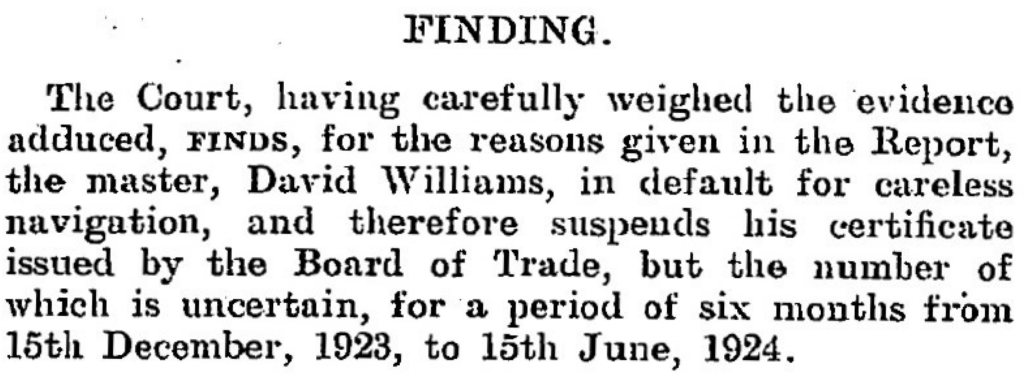
The Halifax inquiry concluded that the captain had exercised poor judgment in maintaining speed without verifying position.
His certificate was suspended.
But the outcome had already been decided long before that ruling.


A Narrow Escape
In the end, the loss of the City of Washington became something rare in the history of the North Atlantic.
A disaster without death.
More than five hundred people had crossed an ocean, entered a wall of fog, and driven full speed onto a hidden shoal.
And yet, within hours, every one of them stood on land.
Alive.
Had the timing been different, the story would have been told another way.
Had the ship struck at night, or in heavy seas, there would have been no orderly evacuation. No small boats finding their way through the fog.
Only wreckage.
Only loss.
The answers, when they came, were measured in degrees, miles, and decisions made in fog.
But out along the coast of Nova Scotia, none of that mattered anymore.
There, the sea had already taken what it would.
The City of Washington lay broken across the shoal where she had come to rest—her hull opened, her cargo scattered, her passage finished within sight of land.
The fog still comes in along that coast.
It still closes the horizon.
And somewhere beneath it, what remains of the ship waits in the same place it settled in July of 1873.
Not as a tragedy.
But as a margin.
A distance measured not in miles—
but in how close more than five hundred lives came to being lost.
Ask me about the Highfield and Suzuki offshore expedition platform — engineered for serious divers.
#HighfieldHunter #HighfieldPatrol760 #SuzukiEngines #Suzuki-300hp #HalifaxShipwrecks #NSMaritimeHistory #NovaScotia #CityOfWashington

Matthew Atlantic
Steel, Salt, and Second Lives: The Story of Matthew Atlantic
Highfield Hunter
Names Beneath the Surface
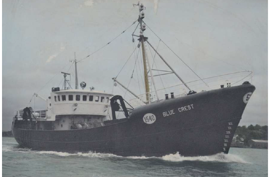
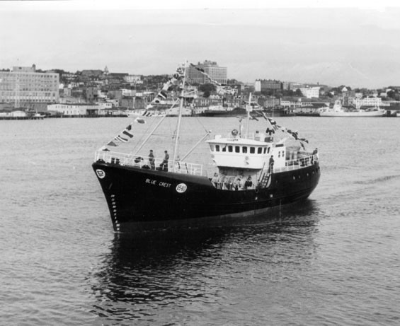
Before I can properly tell the story of the Matthew Atlantic, I must begin decades earlier — under a different name, and in a different era of Newfoundland’s fishery. Long before she carried the identity she is known by today, the vessel was launched in 1964 as Blue Crest, a steel trawler built during the final years of Newfoundland’s traditional industrial fishing expansion. In some secondary records and informal references, the name has occasionally been misrepresented as “Blue Haze,” a small but persistent error that has followed her through time.
Her name did not remain Blue Crest for long. Ownership and operational transitions brought an interim identity — Atlantic Mildred — a lesser-known but important chapter in her lineage. That brief renaming marked a period of change, likely reflecting shifting company structures or sales during the turbulent late 1960s, when many long-standing Newfoundland fishing enterprises were consolidating or closing.
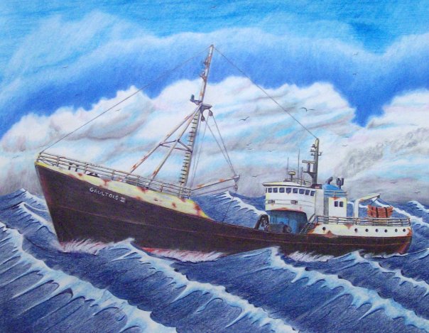
From there, she became Gaultois II, a name more firmly rooted in Newfoundland’s south coast fishing communities. Under that title, she worked through another chapter of Atlantic service, tying her history to outport life and the evolving offshore fishery. Only after these transformations — Blue Crest, Atlantic Mildred, Gaultois II — does the vessel emerge in her final and most recognized form: Matthew Atlantic.
To understand Matthew Atlantic is to understand the vessel that came before her — and the layered history carried forward in steel, registry numbers, and saltwater memory.
Only after understanding those earlier identities — Blue Crest, Atlantic Mildred, Gaultois II — can we arrive at Matthew Atlantic with clarity. In shipwreck research, names are more than labels; they are entry points. Each one marks a different era, a different crew, a different coastline. To tell the story properly, we begin at the beginning.
Forged in Steel — Pictou Shipyards
Before she was Blue Crest, before any crew signed aboard or nets were shot over her stern, the vessel began in steel and flame along the Northumberland Strait at Pictou Shipyard in Pictou, Nova Scotia. Founded in 1856 as the Pictou Iron Foundry by William Henry Davies, the yard evolved with the industry itself — from ironworks to full steel ship construction — adapting to the technological shifts that transformed maritime trade and fishing through the late 19th and early 20th centuries.
Ownership passed through generations and partnerships: the Davies family, then Joseph Robb and Douglas Hannon, and in 1906 to Allan A. Ferguson, who reorganized operations as the Pictou Foundry & Machine Company. After 1942, it operated as Ferguson Industries, a name closely associated with wartime production and post-war industrial shipbuilding. During the Second World War, the yard reached its peak, constructing 24 “Park” ships — Canadian-built cargo vessels such as SS Victoria Park — that formed part of the Allied merchant fleet lifeline across the Atlantic. In the decades that followed, the yard produced more than 100 post-war vessels, including trawlers, barges, and coastal working ships that would define maritime industry throughout Atlantic Canada.
By the time Blue Crest was laid down in 1964, she was emerging from a yard with deep industrial roots and wartime pedigree. The same slipways that had launched cargo ships for global conflict were now building steel trawlers for Newfoundland’s offshore fishery. The shipyard’s eventual bankruptcy in 1984 marked the end of an era, though the site continues under new ownership as Aecon Atlantic Industrial Inc., a reminder that maritime industry in Nova Scotia has always evolved rather than disappeared.
Understanding this builder context matters. Blue Crest — later Atlantic Mildred, Gaultois II, and ultimately Matthew Atlantic — was not a small craft of local origin. She was a product of one of Nova Scotia’s most historically significant industrial yards, built in steel by a company that had shaped wartime logistics and post-war Atlantic fisheries alike. Her story begins now.
The Offshore Machine — Blue Crest (1964–1968)
When she was launched in October 1964 as Blue Crest, the vessel entered service at a very specific moment in Newfoundland’s maritime history — the final surge of the large, company-owned offshore trawler era. Built at Ferguson Industries in Pictou, Nova Scotia, she measured approximately 130 feet in length and 331 gross tons, a steel-sided industrial fishing vessel designed for endurance and production rather than coastal convenience. She was not an inshore boat working within sight of land; she was built for the offshore grounds.
Her original owner, Job Brothers & Co., Limited of St. John’s, placed her squarely within one of Newfoundland’s historic mercantile fishing empires. Job Brothers had been operating since the 18th century and by the mid-20th century functioned as a vertically integrated enterprise — owning vessels, managing processing facilities, exporting fish, and supplying the very fleets that harvested the catch. A vessel like Blue Crest was part of that larger machine. She would have steamed to the Grand Banks or other offshore grounds, towed heavy trawl gear across cold Atlantic bottom, and returned with holds filled with cod and other groundfish destined for company plants and export markets.
Operationally, this places Blue Crest firmly within the industrial groundfish fishery. Her days would have revolved around setting and hauling nets, sorting catch on deck in harsh weather, icing or storing fish below, and turning back toward St. John’s when the holds were full. These were long trips in exposed waters — steel hull, working deck, winches straining under load — part of the demanding rhythm of offshore trawling in the 1960s.
Yet her service under that name was likely brief. By 1967, Job Brothers’ remaining St. John’s operations were shutting down amid consolidation and structural change within Newfoundland’s fishery. That timing aligns closely with Blue Crest’s name and ownership transition around 1968. Her identity as Blue Crest, therefore, represents both a beginning and an ending — launched during the last phase of Newfoundland’s traditional industrial fishing era, and renamed just as that world was beginning to close.
In tracing her as Blue Crest, we are not simply identifying an early name; we are placing the vessel inside a fading chapter of Atlantic maritime history — one defined by company fleets, offshore trawlers, and a fishery on the brink of profound transformation.
A Name Between Eras — Atlantic Mildred
The brief appearance of the name Atlantic Mildred in the vessel’s history likely reflects a transitional moment rather than a full operational reinvention. In commercial shipping and fisheries, interim renames commonly occur during ownership transfers, financing arrangements, corporate restructuring, or registry changes. The ship herself often continues working much as before — but on paper, she belongs to someone new.
While available records confirm that the name existed within the timeline between Blue Crest and Gaultois II, they do not clearly explain the reasoning behind it. What it suggests, however, is movement: a vessel shifting hands during the late 1960s, a period when Newfoundland’s fishing industry was consolidating and long-established firms were closing or restructuring.
In the broader narrative, Atlantic Mildred represents a hinge point — a short-lived identity marking the space between one era and the next. It is a reminder that ships, like the industries they serve, evolve through transition.
The South Coast Years — Gaultois II and Outport Industry
When the vessel became Gaultois II (Official Number 322298), she entered what would be one of the longest and most community-rooted chapters of her life. No longer tied to a St. John’s mercantile empire, she was now connected directly to the outport of Gaultois on the south coast of Newfoundland and Labrador. Here, the vessel was part of the working fleet that supplied the local fish plant — an operation originally established in 1952 by H.B. Clyde Lake and later known as Gaultois Fisheries. For decades, the plant was the economic heart of the town, and vessels like Gaultois II were its lifeblood.
The arrival of the vessel in Gaultois was remembered not simply as the addition of another fishing boat, but as a moment of genuine community pride. Nadine Northcotte, who grew up in the community, remembers sitting at the kitchen table with her parents while they talked about what the new vessel should be called. She wrote down one of the suggestions that evening — “Gaultois II.” When the ship finally arrived, the community gathered at the government wharf in numbers large enough to fill the shoreline. There was ceremony to mark the moment, including the traditional breaking of a bottle of champagne across the bow — a gesture that carried both celebration and hope. For a small outport whose economy revolved around the fish plant and the boats that supplied it, the arrival of a modern steel dragger was more than symbolic. It represented opportunity, stability, and the promise of work tied directly to the waters of Hermitage Bay.
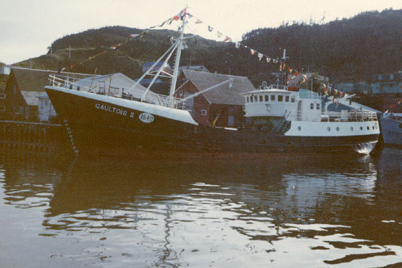
As a dragger, she worked the surrounding fishing grounds of Hermitage Bay and the broader south coast — waters long known for productive bottom fisheries. Alongside sister vessels such as Hermitage, she targeted groundfish including cod and redfish, towing gear across the cold Atlantic floor and returning to unload directly into the processing system that sustained the community. This was not distant corporate fishing; it was regional industry, tied tightly to place and people.

Her years as Gaultois II spanned a dramatic period in Newfoundland’s fisheries history. The 1970s and 1980s marked both the height of the modern groundfish fleet and the early signs of strain that would ultimately lead to collapse. In that sense, the vessel represents more than a renamed trawler — she embodies the rise and decline of a generation of Newfoundland draggers. Through prosperous landings and tightening quotas, she remained part of a fleet that defined coastal working life on the south coast.
In tracing this era, we see the ship not simply as steel and registry numbers, but as a participant in community rhythm — steaming out of Gaultois harbour at first light, working the banks of Hermitage Bay, and returning to the plant that kept the town alive.
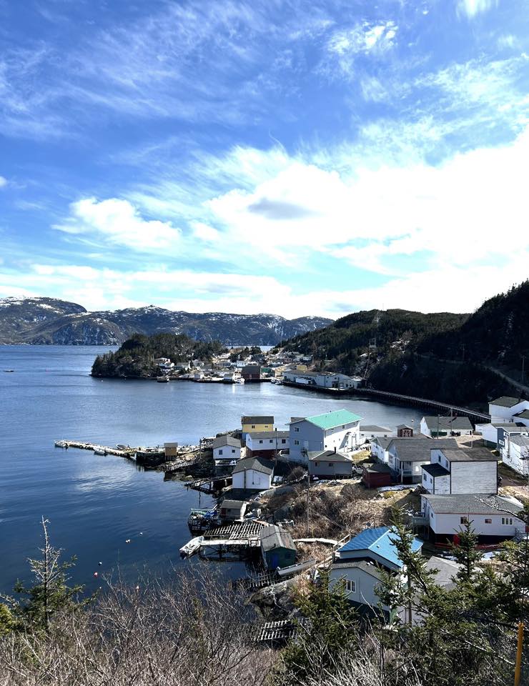
Landscape and Community — Gaultois
On the south coast of Newfoundland and Labrador, where the land fractures into coves and narrow fingers of rock, sits the isolated outport of Gaultois. There are no roads that lead here — only water and weather. The community clings to the edge of the Atlantic, its wooden homes rising from the shoreline on stilts, facing a harbour that has sustained generations of fishers, mariners, and boatbuilders.
Gaultois exists in rhythm with the sea. Fog rolls in without warning. Tides expose jagged rock and hidden shoals. In winter, storms sweep up from the southwest, driving heavy swell through the passages and testing both vessels and resolve. It is a place where seamanship is not romantic — it is necessary.
For more than a century, coastal steamers and supply vessels threaded these waters, connecting scattered outports to the rest of Newfoundland. Before highways and ferries reshaped transportation, ships were lifelines. Cargo, mail, livestock, and passengers all depended on captains willing to navigate the intricate coastline and its unforgiving reefs.
It is in this environment — remote, beautiful, and often unforgiving — that the deeper story of the Matthew Atlantic truly begins. Along Newfoundland’s south coast, the ocean has always been both provider and taker: sustaining communities through generations of fishing, while also claiming vessels when weather, timing, or fortune turned against them. Every harbour carries stories, and many of them rest beneath the surface.
In this case, however, the story does not begin with a sinking. As Gaultois II, the vessel did something different — she left. After years working the fisheries of Hermitage Bay and the south coast, she departed Newfoundland and made her way to Nova Scotia. That movement marked another turning point in her long identity shift, carrying with her decades of fishing history into new waters and a new chapter that would eventually lead to the name Matthew Atlantic.
Westward Again — Nova Scotia and the Birth of Matthew Atlantic
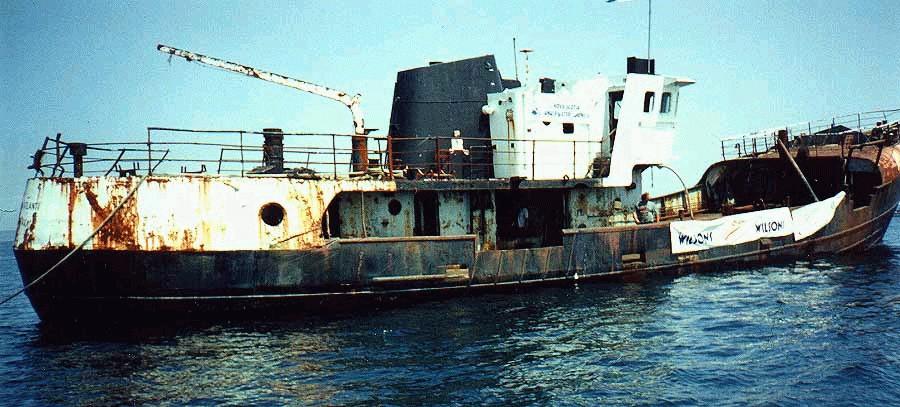
When the vessel left Newfoundland in the late 1980s, she entered a distinctly different phase of her working life. Acquired by Continental Seafoods of Shelburne, Nova Scotia, the 122-foot steel side trawler was purchased from a Newfoundland fish company during a period of restructuring within the Atlantic fishery. With the transfer came another identity change — she was renamed Matthew Atlantic, a name that would follow her into her final working decade.
Under Continental Seafoods, the vessel was converted from a traditional groundfish dragger into an offshore lobster boat, reflecting the economic realities of the time. By the late 1980s and early 1990s, the Atlantic groundfish industry was in steep decline, while lobster remained one of the few stable and lucrative fisheries. The conversion represented adaptation — not retirement. The steel hull that had once towed bottom gear on the south coast of Newfoundland was refitted to serve a new fishery along the coast of Nova Scotia.
After her tenure with Continental Seafoods, the vessel changed hands again. Eventually, her working life came to a close, and rather than being scrapped, she was intentionally scuttled in August 1998 to create an artificial reef at Port Mouton, Nova Scotia — now part of what is commonly referred to as the Spectacle Marine Underwater Dive Park. There, the Matthew Atlantic rests on the sandy bottom, transformed once more — from industrial trawler, to lobster boat, to submerged structure supporting marine life and divers’ exploration.
In that final transformation, the vessel completed a full Atlantic arc: built in Nova Scotia, worked in Newfoundland, returned to Nova Scotia, and ultimately became part of the underwater landscape she had spent a lifetime navigating above.
Today, she rests on a sandy bottom in Port Mouton and has become a known local dive site—one of those rare cases where a working vessel’s “end” became a second life underwater.
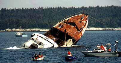
A Planned Descent — The Scuttling — August 8, 1998
On August 8, 1998, at approximately 2:19 p.m., the Matthew Atlantic began her final descent — not as a casualty of storm or collision, but as part of a deliberate plan. Rather than explosives, her sinking was controlled and methodical: sea cocks were opened, allowing the Atlantic to reclaim the steel that had worked its waters for more than three decades. There was no violence in the act, only gravity and time. She settled upright on a sandy bottom, an intentional placement designed for stability and diver access.
The scuttling was a collaborative effort involving the Artificial Reef Society of Nova Scotia, the Region of Queens Municipality, and local stakeholders who saw value in giving the vessel a second life beneath the surface. Artificial reefs were becoming recognized not only as habitat generators, but as economic and recreational assets — drawing divers, supporting marine growth, and preserving working vessels in situ rather than reducing them to scrap.
Her resting place lies off Port Mouton, Nova Scotia, within what is commonly referred to as the Spectacle Marine Underwater Dive Park. Nautical charts mark the position clearly with a cautionary note: “Dive Site — Caution.” The wreck sits in approximately 60 feet (18 metres) of water, accessible to recreational divers yet deep enough to retain the atmosphere of a true Atlantic working ship.
Unlike so many vessels whose stories end abruptly, the Matthew Atlantic was given a structured farewell. She did not vanish; she was repositioned — transformed from trawler and lobster boat into artificial reef, from industrial asset into underwater landmark. In doing so, her story did not conclude. It simply shifted below the tide line.
Return — 2025
I first returned to the Matthew Atlantic in 2025, not simply as a diver, but while conducting sea trials with a newly built side scan sonar. The wreck is clearly marked on nautical charts off Port Mouton, and on this occasion the charted position proved reassuringly accurate. As I passed over the coordinates, the sonar screen lit up with the unmistakable profile of a large steel vessel — a strong return, elongated and defined, her structure casting a clear acoustic shadow across the sandy bottom.
Descending through roughly sixty feet of water, I found her resting not upright as originally placed, but on her port side, the starboard flank rising toward the surface. Time and Atlantic swell have shifted her slightly since 1998, but she remains largely intact. It is an easy descent, and the wreck lends itself to a full circuit on a single dive — bow to stern without haste.
Marine growth has claimed her in thick layers. Steel is no longer the dominant colour; instead, she wears the Atlantic. Plumose anemones cluster along railings and openings. Blue mussels and sea stars cling to exposed surfaces. Kelp and sea lettuce sway gently where sunlight reaches. Orange and white colonial tunicates spread across the hull plating, softening the hard industrial lines of what was once a working trawler. The wreck hums quietly with life — juvenile pollock weaving through openings, cunner holding tight to structure, the occasional lobster tucked into shadowed recesses. The artificial reef has become precisely what it was intended to be.
It was near the stern that something broke the natural pattern. A thick orange rope, clearly modern, rose from the seabed and drifted upward in a loose arc. It did not belong to the wreck. Following it down through the low swell, I found its source: a modern Danforth anchor, roughly two feet long and surprisingly heavy, resting partially embedded in the sand. Most likely it had been lost from a dive vessel — dropped to hold position over the wreck and never recovered.
I surfaced to retrieve a lift bag and reel. On the second descent, I secured the bag to the anchor, inflated it carefully until the weight became neutral, and began the controlled ascent. From there I swam back toward my boat, unwinding the reel behind me — laying a clear path that would later allow me to bring the anchor to my boat.
It was a small recovery, but fitting. The Matthew Atlantic had once hauled nets from the ocean floor. Now, resting quietly beneath the tide, she had given something back.
Because of the wind that afternoon, my boat had been moored carefully — one anchor line leading down across the wreck itself, and a second line running back to the boat to keep us positioned safely off the structure. The departure was planned deliberately. The idea was simple: maneuver the boat so both lines would clear cleanly, allowing us to recover my anchor line and then retrieve the newly discovered Danforth without fouling anything below.
Even the best-laid plans have a way of testing resolve.
As we repositioned and began hauling, it became clear almost immediately that something was wrong. The line attached to the recovered anchor would not rise. It came tight — solid, unmoving. Somewhere below, it had found purchase again. Whether on the wreck, debris, or contour in the sand, it was once more pinned to the bottom.
I am stubborn by nature. I could not leave it there. The sea had already claimed enough gear over the years.
So, I donned my dive gear again and followed the line back down. Then again. And then once more. Three dives to the Matthew Atlantic in a single day — each descent familiar now, the hull resting on her port side, marine growth drifting softly in the surge. On the final dive, I traced the snag to its hold, worked the tension free, and deliberately rerouted the line well clear of the wreck before ascending.
Back on the surface, we hauled steadily. This time the line rose cleanly. The anchor broke the surface beside the boat — heavy, mud-streaked, and finally ours again.
With both anchors aboard and the lines stowed, we pointed toward the dock at Port Mouton and headed in. Beneath us, the Matthew Atlantic returned to quiet, settled again into sand and tide — unchanged by our brief struggle above, but no less a part of the day’s story.
Plan Your Port Mouton Expedition
Getting There:
2-hour drive from Halifax via Highway 103 to Exit 21. Turn left on Port Mouton Connector Road, then right on Number 3 Highway. Continue left on Central Port Mouton Road, then left again on Central Port Mouton Breakwater Road to harbor access (15 min west of Liverpool).
Lodging & Dining:
- Port Mouton Bay Cottages & Restaurant
- Quarterdeck Resort, Summerville Centre
- White Point Beach Resort, Hunts Point
Diving:
- Bring your own boat or contact local fishermen at Port Mouton Harbour to arrange charters
- Primary: Matthew Atlantic artificial reef (43°54.146' N, 64°47.305' W | 60ft | west side island)
- Secondary: River Wye wreck (20-50ft | outboard side of Port Mouton Island | marine life hotspot) — see my full writeup: River Wye
Local Resources:
- Port Mouton Harbour Authority: 902-683-2555

Wreck Coordinates:
- Matthew Atlantic: 43°54.146' N, 64°47.305' W | 60 ft | Sand/Rock
- Boat Ramp: 43°55.135' N, 64°50.616' W
Vessel Specs: Matthew Atlantic — 331 GRT, 130 ft, Steel Hull
Modern survey technology—when paired with rigorous historical research and professional dive operations—continues to reveal and preserve the stories of vessels long thought lost to time and tide. The Port Mouton region stands ready to welcome the next generation of maritime explorers.
Dive Safety Notice: Professional dive operations are strongly recommended. Strong tidal currents, and challenging sea conditions require proper training, equipment, and local knowledge. These shared coordinates now guide future explorers, blending SCUBA with Nova Scotia's maritime heritage.
The confirmation of the River Wye's location represents a meaningful contribution to Atlantic Canada's maritime archaeology. The wreck's depth, proximity to Halifax, and well-documented historical record make it an exceptional site for future research, documentation, and recreational diving education. Modern survey technology—when paired with rigorous historical research and professional dive operations—continues to reveal and preserve the stories of vessels long thought lost to time and tide.
Ask me about the Highfield and Suzuki offshore expedition platform — engineered for serious divers.
#HighfieldHunter #HighfieldPatrol760 #SuzukiEngines #Suzuki-300hp #HalifaxShipwrecks #NSMaritimeHistory #NovaScotia#PortMouton #MatthewAtlantic

River Wye
The Tragic Fogbound End of the River Wye: A Nova Scotia Shipwreck Tale
Highfield Hunter
In the grey dawn of November 24, 1923, the British cargo steamer River Wye—a weathered survivor of World War I's brutal seas—met its end on the jagged rocks off Port Mouton Island, Nova Scotia. What began as a routine coal run from Saint John, New Brunswick, to Boston turned into a harrowing tale of fog, mis-navigation, and narrow escape, etching the ship's story into Atlantic Canada's maritime lore.
From Teesside Shipyard to Tramp Trader
Launched in 1906 as SS Glamorgan by Craig, Taylor & Co. Ltd. at their Thornaby-on-Tees yard on England's River Tees, the 3,576 GRT steel steamer measured 342 feet long with a 51-foot beam. Built for Jenkins Bros. of Cardiff (yard #~140), she was renamed River Wye later in her career. The yard, founded in 1885 amid Teesside's industrial boom, specialized in versatile tramps and colliers, producing over 300 vessels before closing in 1931 due to the Great Depression.
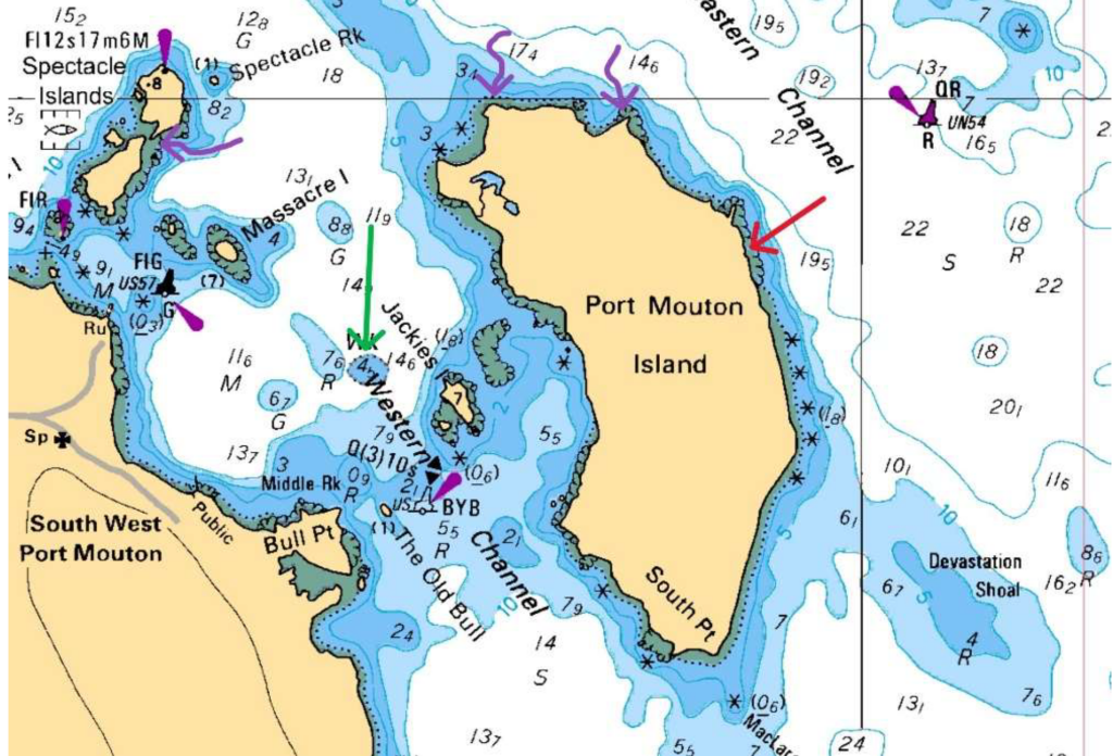
features, depth contours (5-22 meters shown), and marked wrecks (River Wye (red) and Matthew Atlantic (green, also
three potential wrecks (purple)). The stranding location aligns with charted shallow water and rocky hazards that claimed
the River Wye in 1923.
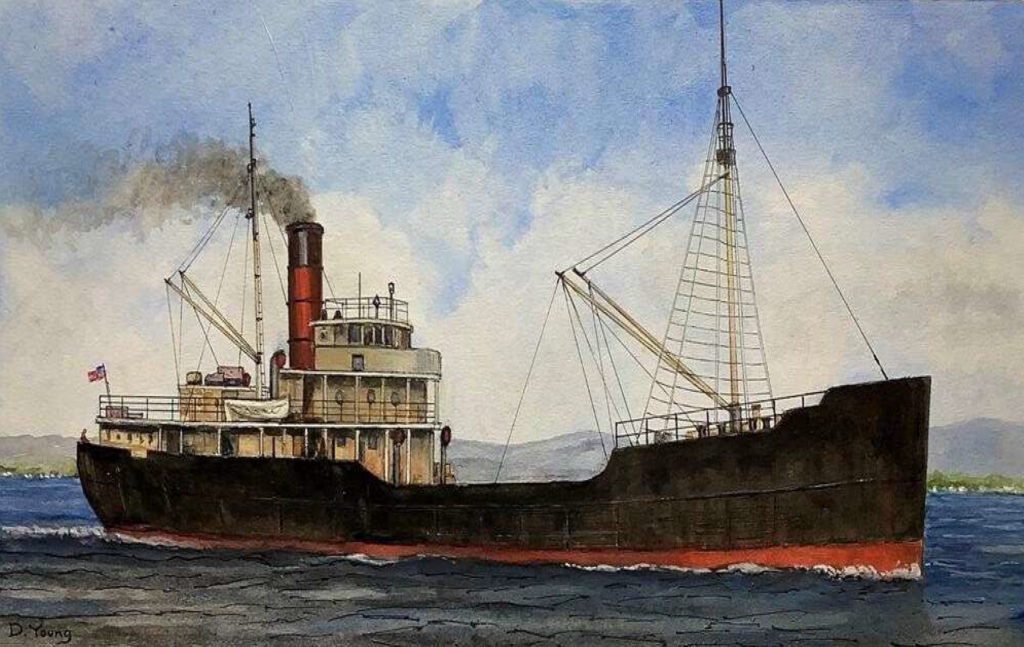
characteristic single red funnel, two-mast configuration, black hull with red anti-fouling bottom, and steel construction.
This vessel type exemplifies the tramp steamer design that defined River Wye's class and operational profile
River Wye embodied the era's tramp steamer life: shuttling coal from UK ports to South America, the Mediterranean, and North American grain/coal trades. Owned by Llewellyn, Merrett & Price of Cardiff—which managed the vessel through the post-WWI era—she passed hands following the decline of the traditional tramp steamer trade. No major incidents marred her record until that fateful 1923 voyage.
The Final Voyage: Fog's Deadly Deception
On November 22, Captain David Williams departed Swansea (UK) with 27 crew, loaded with coal for Boston (US). Fog rolled in thick off Nova Scotia's south shore, a notorious hazard for coastal shipping. From a prior fix at 44°46'N, 61°21'W, the ship steered S. 62° W at 7.5 knots, but without celestial sights, their position unraveled.
At ~6:15 a.m. on the 24th, lookout David Evans peered into the murk—visibility under 14 ship lengths (~250 yards)—and saw nothing until the crunch of rocks at Port Mouton Island (initial reports: 44°00'N 64°20'W). The ship stranded near the island amid stormy seas, becoming a total constructive loss valued at £40,000. Remarkably, no lives were lost; all hands abandoned ship and were rescued by the local Port Mouton residents.
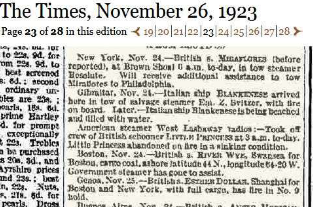
official notification of the vessel's stranding near Port Mouton Island and rescue of the crew.
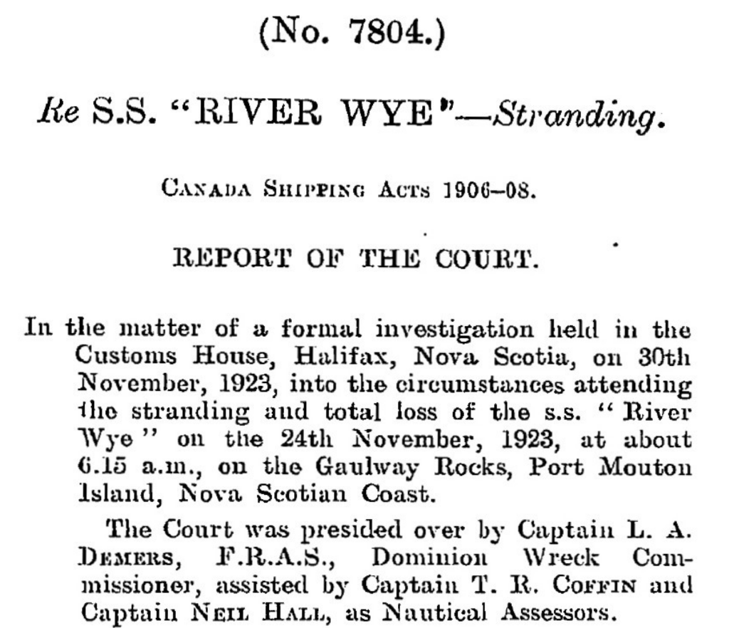
Customs House, November 30, 1923, under Dominion Wreck Commissioner Capt. L.A. Demers, F.R.A.S
Precise Wreck Location and Accessibility
Updated coordinates pinpoint the site at 43°54.487' N, 64°45.418' W (decimal: 43.9081° N, 64.7570° W), off the island's east coast amid rocky ledges in 20-50 feet of water—ideal for recreational diving from Halifax, just a two-hour drive (~150 km southwest). This nearshore spot aligns with Port Mouton's nautical charts and local 1923 stranding records.
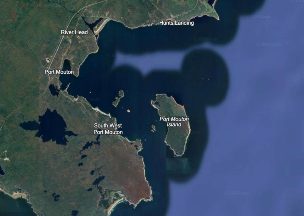
Point, Hunts Landing, River Head, and Port Mouton settlement. The wreck site coordinates (43°54.487'N, 64°45.418'W)
place the River Wye wreck off the island's east side amid rocky outcrops and shallow waters.
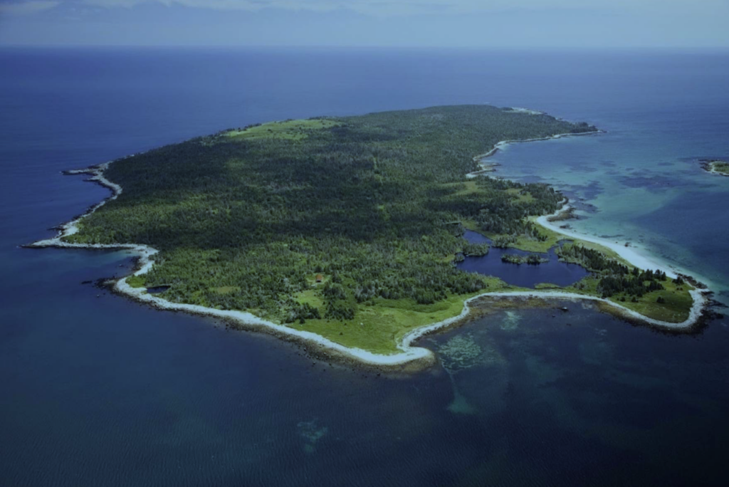
River Wye stranded on the eastern side (left side of photo. The rocky ledges and shallow offshore waters visible in this
image match the hazardous conditions documented in the 1923 inquiry records.
The Halifax Inquiry: Blame on the Bridge
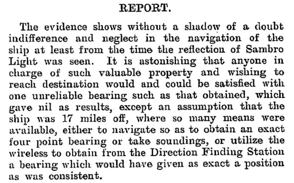
The formal investigation (No. 7804) conducted November 30, 1923, at Halifax Customs House under Dominion Wreck Commissioner Capt. L.A. Demers, F.R.A.S., with Assessors Capt. T.R. Coffin and Capt. Neil Hall. Witnesses—Master David Williams, 2nd Engineer G.J. Humphrey, 2nd Officer J.E. Herbert, 1st Officer R. Jones, wheelsman J.T. Garnett, and lookout David Evans—detailed the haze post-unreliable noon fix (44°46'N 61°21'W) and single Sambro Light bearing. The Court condemned Williams' "indifference and neglect" for skipping soundings, Chebucto Head wireless bearings, or fixes despite SE winds; Herbert was censured for poor lookout amid visibility disputes (4-5 miles claimed vs. Evans' 1 shiplength). Williams' certificate was suspended 6 months (Dec 15, 1923–Jun 15, 1924); others mostly exonerated. The verdict highlighted the River Wye (3,576 GRT, Official No. 123170; Swansea to Boston) as lost to careless navigation on a prudent coast.
Port Mouton, a rugged outpost on Nova Scotia's "Gravely Coast," claims another chapter in the province's 20th-century wreck tally. River Wye's story endures as a cautionary saga of human error against nature's veil—her bones a potential gem for local maritime research.
Modern Rediscovery: Pinpointing with Side-Scan Sonar
Fast-forward a century: though previously dove, the wreck's precise coordinates were elusive until August 31, 2025, when—operating from my Highfield Patrol 760—I towed side-scan sonar across promising sections near Port Mouton Island. The Patrol 760 handled the towing configuration flawlessly, maintaining stable positioning even in choppy tidal currents, while high-resolution acoustic imaging revealed a distinctive "feather-like" shadow.
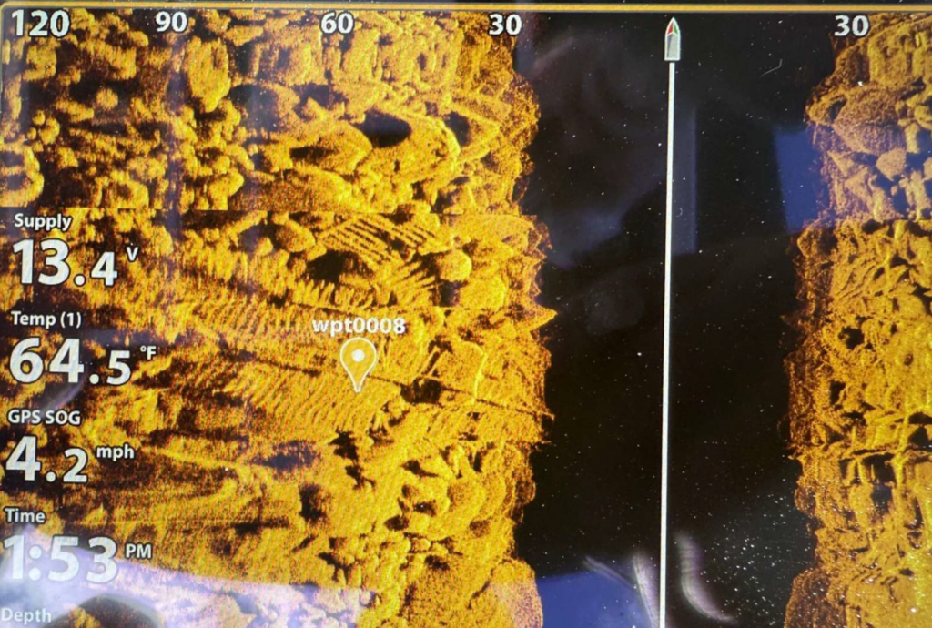
hull structure. The high-resolution sonar data clearly reveals the exposed ribs and framing of the steamer wreck. Waypoint
wpt0008 marks the sonar contact at coordinates 43°54.487'N, 64°45.418'W. The sonar target display shows supply voltage
13.4V, temperature reading 64.5°F, and GPS speed-over-ground of 4.2 mph, documenting the precise survey conditions.
Depth indicator: approximately 30 feet.
This methodical survey paid off with the shipwreck finding, validated by subsequent diving; Highfield's rugged aluminum design proved essential to this breakthrough, enabling precise gear deployment where lesser boats would struggle. Today, the wreck features lots of wreckage to explore including a 120-foot shaftline precariously spanning large boulders, offering recreational divers a thrilling swim-under passage.
Experience Maritime Nova Scotia: Legacy & Discovery
The River Wye rests in 20-50 feet of Atlantic waters—accessible yet challenging—a time capsule of Edwardian maritime tragedy. Port Mouton Island represents everything Atlantic Canada offers: rugged coastline, fishing heritage, protected harbors, and underwater archaeology. The River Wye discovery showcases modern survey capability meeting historical passion—available now to divers, researchers, and maritime enthusiasts.
From Highfield's aluminum hull weathering choppy seas to local fishing charters supporting certified divers, the region's economy has access and adventure. The 988-acre island's white-sand beaches and wooded trails complement world-class wreck diving. Port Mouton is considered the largest private island on the east coast. This shallow wreck exemplifies Nova Scotia's untapped maritime potential: dozens more lie undocumented along the south shore, waiting for the next generation of Highfield Hunters. Your dive could be the next rediscovery.
Plan Your Port Mouton Expedition
Getting There: 2-hour drive from Halifax via Highway 103 to Exit 21. Turn left on Port Mouton Connector Road, then right on Number 3 Highway. Continue left on Central Port Mouton Road, then left again on Central Port Mouton Breakwater Road to harbor access (15 min west of Liverpool).
Lodging & Dining:
- Port Mouton Bay Cottages & Restaurant
- Quarterdeck Resort, Summerville Centre
- White Point Beach Resort, Hunts Point
Diving:
- Bring your own boat or contact local fishermen at Port Mouton Harbour to arrange charters
- Primary: River Wye (43°54.487' N, 64°45.418' W | 20-50ft | east side island)
- Secondary: Matthew Atlantic artificial reef (~60ft | inboard side of Port Mouton Island | marine life hotspot)
Local Resources:
- Port Mouton Harbour Authority: 902-683-2555
Wreck Coordinates:
- River Wye: 43°54.487' N, 64°45.418' W | 20-50 ft | Sand/Rock
- Boat Ramp: 43°55.135' N, 64°50.616' W
Vessel Specs: River Wye — 3,576 GRT, 342 ft × 51 ft, Steel Hull, 120-ft Shaftline
Modern survey technology—when paired with rigorous historical research and professional dive operations—continues to reveal and preserve the stories of vessels long thought lost to time and tide. The Port Mouton region stands ready to welcome the next generation of maritime explorers.
Dive Safety Notice: Professional dive operations are strongly recommended. Strong tidal currents and challenging sea conditions require proper training, equipment, and local knowledge. These shared coordinates now guide future explorers, blending SCUBA with Nova Scotia's maritime heritage.
The confirmation of the River Wye's location represents a meaningful contribution to Atlantic Canada's maritime archaeology. The wreck's depth, proximity to Halifax, and well-documented historical record make it an exceptional site for future research, documentation, and recreational diving education. Modern survey technology—when paired with rigorous historical research and professional dive operations—continues to reveal and preserve the stories of vessels long thought lost to time and tide.
Mentioned In