
Cape Breton (HMCS)
From Pulp Cutter to Shipwreck Sailor: My HMCS Cape Breton Odyssey
Highfield Hunter
Roots in Inverness: A Small-Town Start
I grew up in the rural town of Inverness, Nova Scotia—a small coastal community where everyone seemed to know everyone else. Back then, in 1996, there wasn’t even specific census data for the village itself; the records covered the entire County of Inverness. The first dedicated report, in 2001, counted 1,248 residents. By the 2021 census, that number had dipped only slightly to 1,228. Like the tides along the shore, some things in Inverness never really change.
I joined the Royal Canadian Navy in May 1996. Just a few months earlier, in January, I don’t think I even knew a Navy existed. That was the reality for many of us in rural Canada at the time. We only had CBC and ATV on an old television hooked to a 20-foot roof antenna. News from the outside world came through snowy reception and local gossip. Hard to imagine now, but high-speed internet and fibre TV didn’t reach my childhood home until 2025—long after I’d left, though my mother still lives there.
The summer before, in 1995, I’d moved back home after my father passed away suddenly. I was nineteen—too young to feel that old but already learning about loss and responsibility. Work was scarce, so I fell back on cutting pulp in the woods: tough, honest labor that left your clothes stiff with frost and your hands blistered but kept you humble.
One evening at The Hoff, the local watering hole, I ran into a high school friend. Over a beer, he asked if I’d drive him to Sydney—about two hours away—for a Canadian Forces Recruiting Centre interview the next morning. I weighed it quickly: a warm highway drive to the “big city,” or another slog through foot-deep snow with a chainsaw and lunch pail. No contest.
By noon, we were there. Instead of waiting in the car, curiosity pulled me inside. That five-minute detour changed everything—from pulp and beer to sailing five of the seven seas (Arctic, North Atlantic, South Atlantic, North Pacific, and Southern) while still enjoying the beer.
A recruiter approached.
Recruiter: “Son, what do you do for a living?”
Me: “Cut wood.”
Recruiter: “Cold time of year for that. Got any hobbies?”
Me: “I enjoy scuba diving.”
Recruiter: “Why not dive for the military? Pick any trade, and you can become a diver.”
Me: “Really?”
Recruiter: “Yes, it’s that easy.”
Me: “Then sign me up as a Marine Engineering Mechanic.”

The salesman in him was strong—and I did not know it at the time, but my eyesight was too poor for Navy diving. Unlike today’s lengthy process, I was sworn in on May 3, 1996, as a “Stoker” (Marine Engineering Mechanic). Eight days later, I was at recruit school in Saint-Jean-sur-Richelieu, Quebec.
That phase could fill its own chapter, so I’ll jump to Canadian Forces Fleet School Esquimalt, where hands-on mechanical training began. Graduation came in December. During the final assembly, a weathered Chief Engineer asked if anyone was from Cape Breton. I raised my hand—the only “Caper” there.
Afterward, he pulled me aside. “I need you to help with something.” When a Chief speaks, you follow. We drove to the far side of Esquimalt Harbour, past decommissioned ships awaiting sale, scrap, or sinking. At a rusted “No Trespassing” gate, he pushed it open and waved me through.
“This,” he said, “is HMCS Cape Breton.”
The Ship’s Legacy
HMCS Cape Breton was the second Canadian warship to bear the name. The first, HMCS Cape Breton (K350), was a River-class frigate commissioned October 25, 1943, at Quebec City. She escorted convoys against U-boats from Halifax to the English Channel, supporting D-Day, before decommissioning in 1945.
The one before me was a Cape-class escort maintenance ship. Launched in 1944 at Burrard Drydock, North Vancouver, as HMS Flamborough Head—one of 21 Beachy Head-class repair ships for the Royal Navy—she measured 441 feet 6 inches long, with a 57-foot beam and 20-foot-10-inch draft (11,270 long tons full load). A triple-expansion steam engine on one shaft delivered 2,500 ihp for 11 knots.
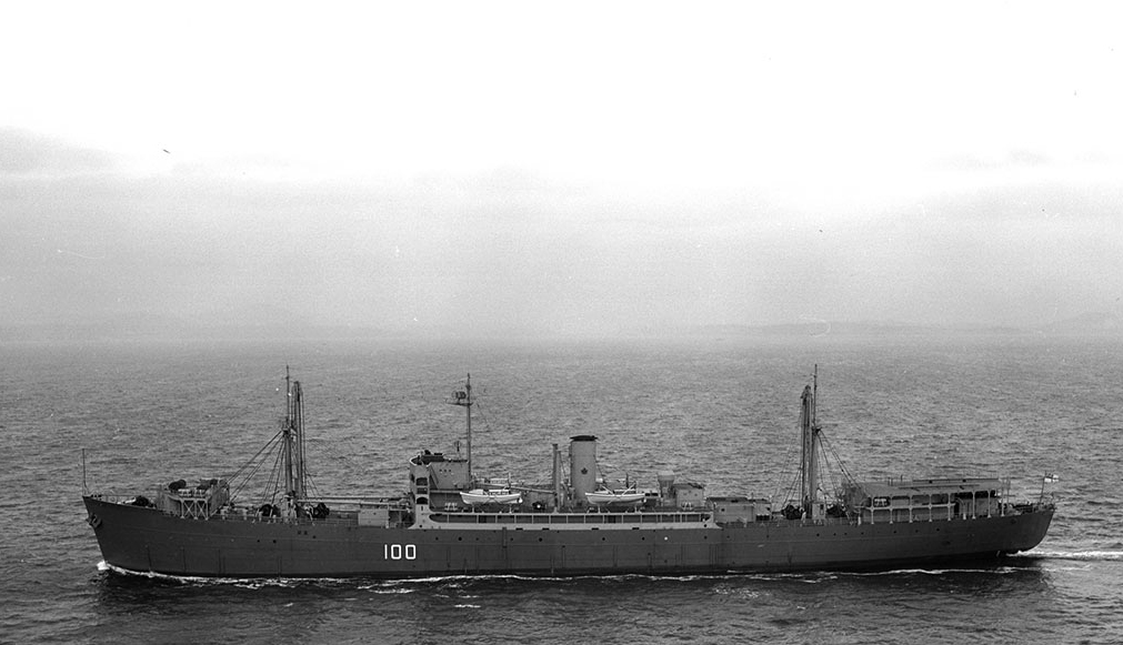
Canada bought her in 1952, commissioning HMCS Cape Breton on January 31, 1953, to bolster Cold War fleet support against Soviet subs. She trained over 300 apprentices from 1953–1958 at HMCS Naden, Esquimalt, before training shifting ashore.
In 1959, Esquimalt refitted her with workshops, a helicopter deck, a decompression chamber, and specialized trades spaces. Recommissioned November 16, 1959, she handled hull, mechanical, electrical, and comms repairs, with sea trials in Mexico’s Magdalena Bay.
She paid off February 10, 1964, serving as Esquimalt’s towed facility until 1993’s Fleet Maintenance Facility Cape Breton replaced her. Sister HMCS Cape Scott did the same on the East Coast with the facility there being named Fleet Maintenance Facility Cape Scott.
On October 20, 2001, cleaned by the Artificial Reef Society of BC, she sank upright off Nanaimo near Snake Island—hull to 145 feet, crow’s nest at 40. She’s still the Pacific Northwest’s largest artificial reef, alive with marine growth and divers.
The Old Girl
Fresh from training, ready to conquer the seas, I crossed that gangway. December air was mild; gentle waves lapped the sleeping giant in a forgotten dockyard corner. Her faded name blistered from salt and sun, yet she held quiet dignity that tightened my chest. My first Canadian warship—decommissioned, but alive with memory’s metallic tang.
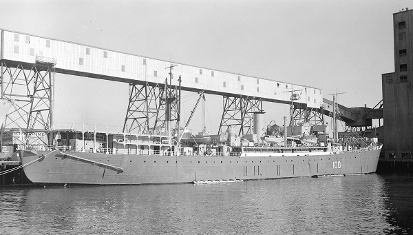
My boots thudded on weathered teak. The Chief—booming at school—spoke softly now.
“She saw storms new boats never will,” he said, hand on rail. “Went places you’ll never go. You’re starting; I’m ending—but every ship carries the stories before.”
I wish I’d asked his name. Too awed then, too young to grasp the rarity. I wonder what became of him—retired seaside, perhaps, still mentoring?
Those words endured. Thirty years on, sailors’ tales I heard echoed them; soon I had my own for the next generation. Her scale awed me. Kneeling, I traced rust-etched wood, pondering her fate.
Years later, my path took me into the Officer Corps, and once again, in 2006, I found myself in Esquimalt for summer training. This time, I had driven across the country and brought my SCUBA gear with me. On a weekend off, I joined a dive charter to visit Cape Breton again—this time beneath the surface.
With nearly a decade of naval experience behind me, the encounter felt entirely different. The ship was blanketed in anemones and kelp, pieces of her hull slowly surrendering to rust. Yet as I swam along her upper deck, I could still see the outlines of what she once was. It was haunting and beautiful. Closing my eyes, I was back on that winter morning, a young sailor listening to an old Chief whose words would define an entire career.
A Legacy Beneath the Waves
Today, building a Facebook group NS Shipwrecks and Stories for Nova Scotia’s wrecks, research loops to Cape Breton. It started with Matthew Atlantic, tracing to Pictou Shipyards’ smaller Park ships, then larger ones—and her.
That deck ignited my sea-and-wreck passion. The Chief showed more than steel; he charted a lifelong course linking service to the wrecks I now document.
Ask me about the Highfield and Suzuki offshore expedition platform — engineered for serious divers.
#HighfieldHunter #HighfieldPatrol760 #SuzukiEngines #Suzuki-300hp #HalifaxShipwrecks #BCMaritimeHistory #BritishColumbia #HMCSCapeBreton
Dufferin Bell
Lost to Records: The Dufferin Bell
Highfield Hunter
Fog cloaks Framboise Cove's jagged shores on Cape Breton's southeast edge, where on May 13, 1951, a forgotten Park ship met its end. Framboise Cove nestles on Cape Breton Island's southeast coast, a rugged inlet where the Atlantic's relentless swell crashes against sheer granite cliffs and boulder-strewn beaches. Just 20 km south of Louisbourg's historic fortress, this remote corner feels worlds away—shrouded in fog half the year, with pounding surf that echoes the fury of countless storms.
Framboise Cove and Communities
Nearby Framboise village clings to the headlands, a tight-knit outpost of lobster fishers and summer folk whose roots trace to Acadian and Mi'kmaq heritage. To the north, Forchu's weathered homes overlook the cove, where locals still swap tales of salvage tugs like the Foundation Josephine racing from Louisbourg—too late to save the freighter. Note there are no dive shops or rentals in the immediate Framboise/Forchu area—plan gear transport accordingly.
Further north (~90 km via Hwy 104), Sydney provides full diver support with hotels, restaurants, and marine supplies as the ideal staging base for expeditions. This "forgotten fringe" of Cape Breton thrives on resilient communities—Richmond County's 8,000 souls blend fishing quotas, eco-tourism, and WWII echoes (nearby UXO dumps linger offshore). Between 1945 and the 1970s, it was common practice for ships to scuttle vast amounts of conventional explosives and chemical weapons (including mustard gas) in these waters.
Park Ships Era
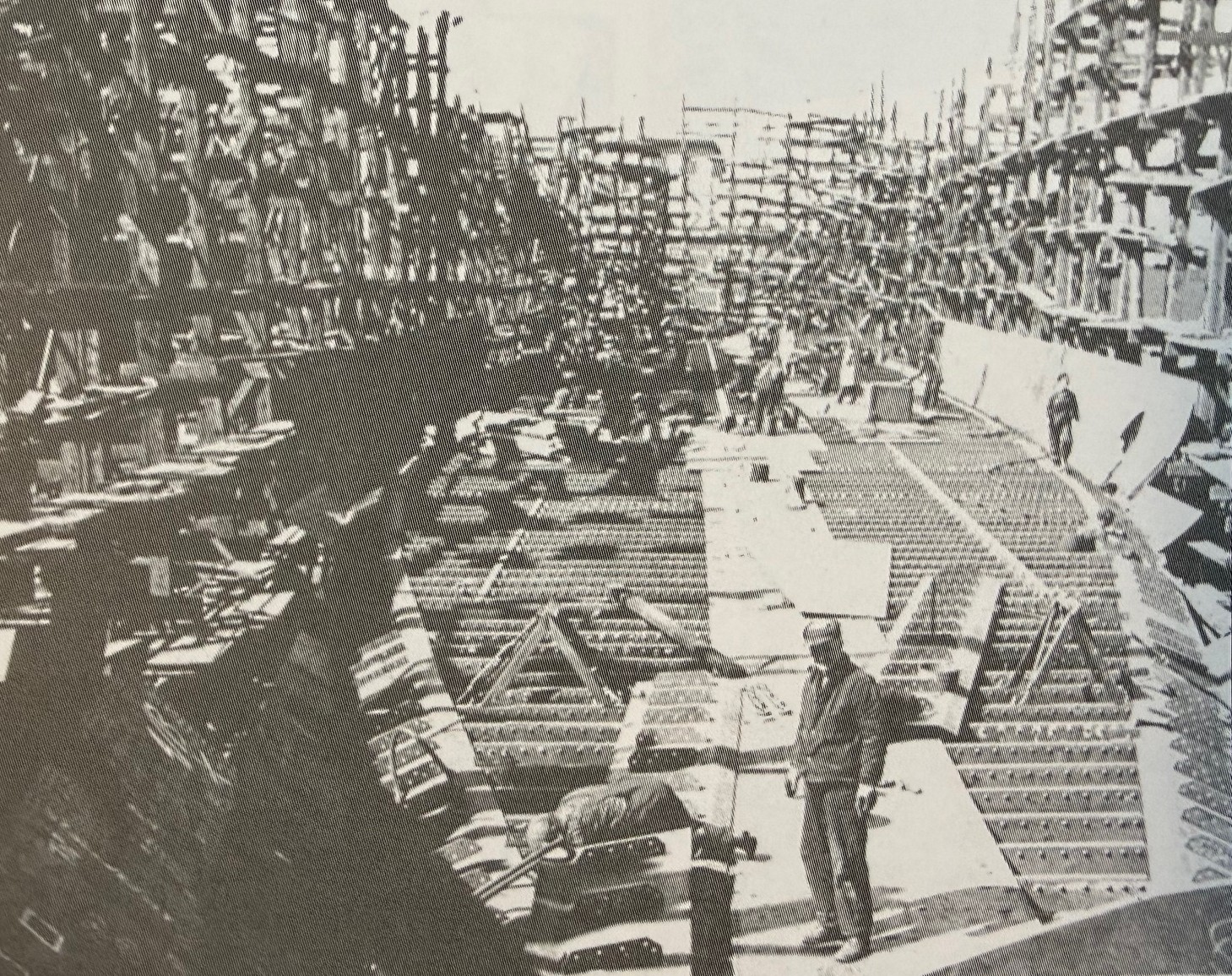
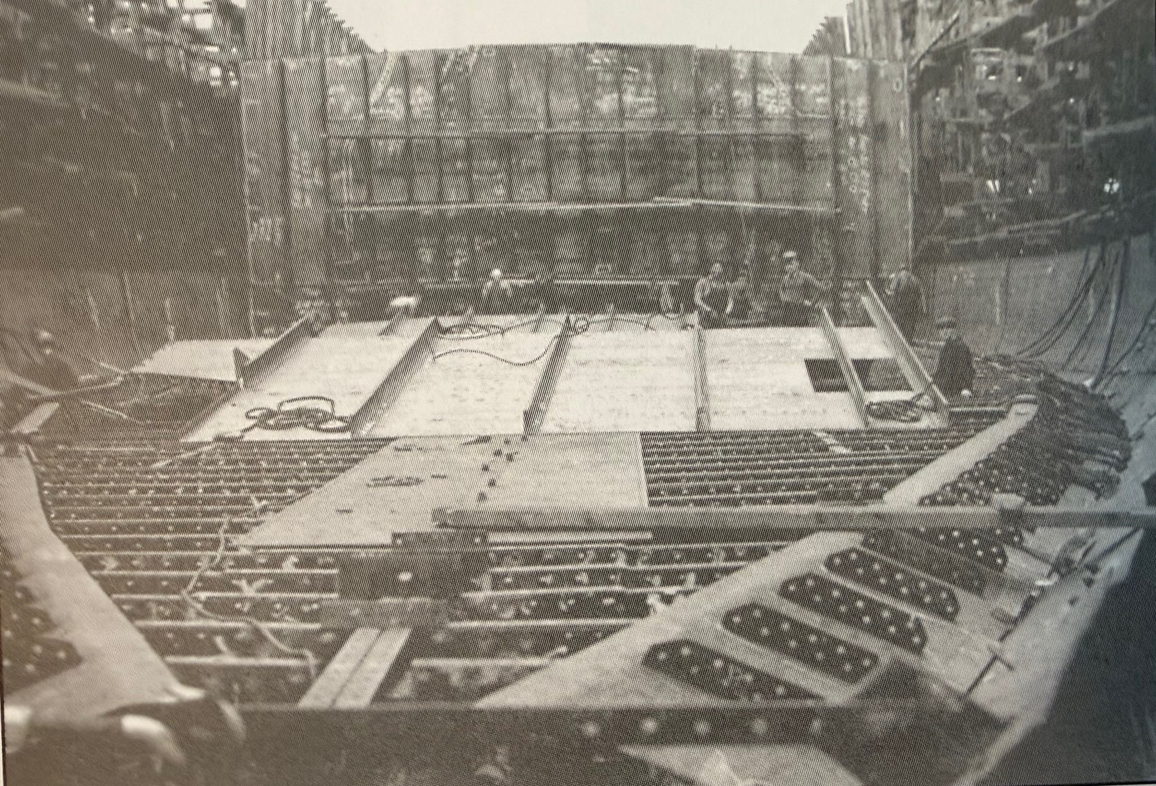
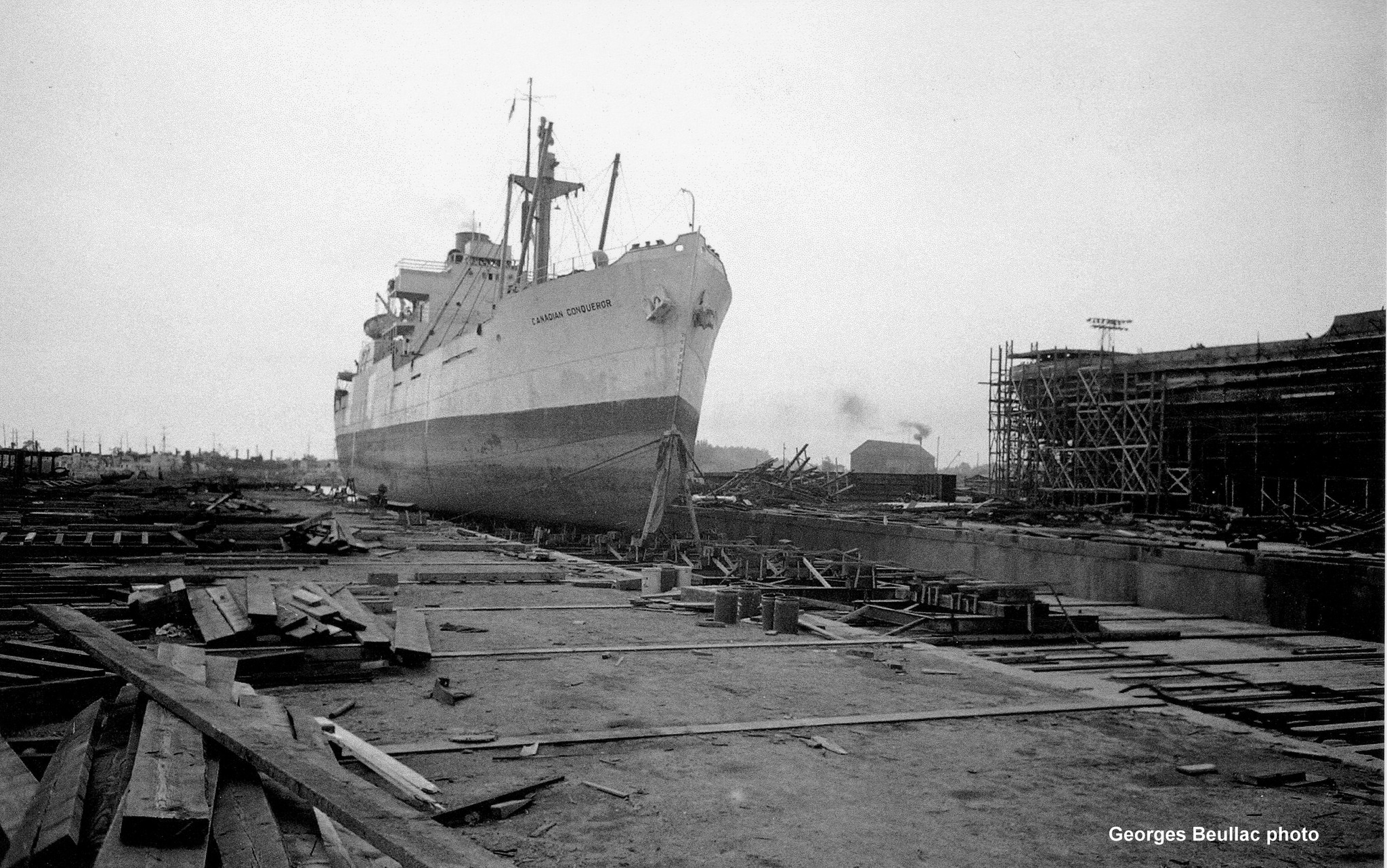
As World War II gripped the globe in 1942, Canada's shipbuilding industry exploded from sleepy pre-war yards into a wartime juggernaut, churning out vessels to counter U-boat carnage in the Battle of the Atlantic. From just 38 ocean-going merchant ships in 1939, the nation ramped up to 57 yards and 38 berths by 1943, employing 57,000 workers—many women stepping into welding torches and rivet guns for the first time. The Park Steamship Company, formed April 8, 1942, spearheaded this effort, ordering 160+ bulk carriers and tankers modeled on Britain's simple North Sands design: no-frills freighters built fast and cheap. Positions in Pictou were created to enable shipbuilding with staff being relocated as required.
Enter the Park ships—176 coal-fired steamers (10,000 DWT class, plus smaller 4,700-tonners) named for Canadian parks like Gatineau or Point Pleasant, launched from yards in Pictou, Saint John, Montreal, and Davie Shipbuilding in Lauzon, Quebec. These 440-ft workhorses, with triple-expansion engines hitting 11 knots, hauled grain, timber, and munitions on 936 perilous voyages, some armed with bow guns and anti-torpedo nets manned by DEMS gunners. By 1945, Canada's yards had birthed 436 merchant ships under government contracts, transforming a peacetime coastal trade nation into an Allied lifeline—yet postwar surplus doomed most to scrap or sale abroad. Dufferin Bell, birthed in this frenzy at Davie Shipbuilding & Repairing Co. in Lauzon, Quebec, embodies the era's grit: rushed to sea as Camp Farnham (later Dufferin Park), renamed for commerce, and bound for obscurity in Framboise Cove.
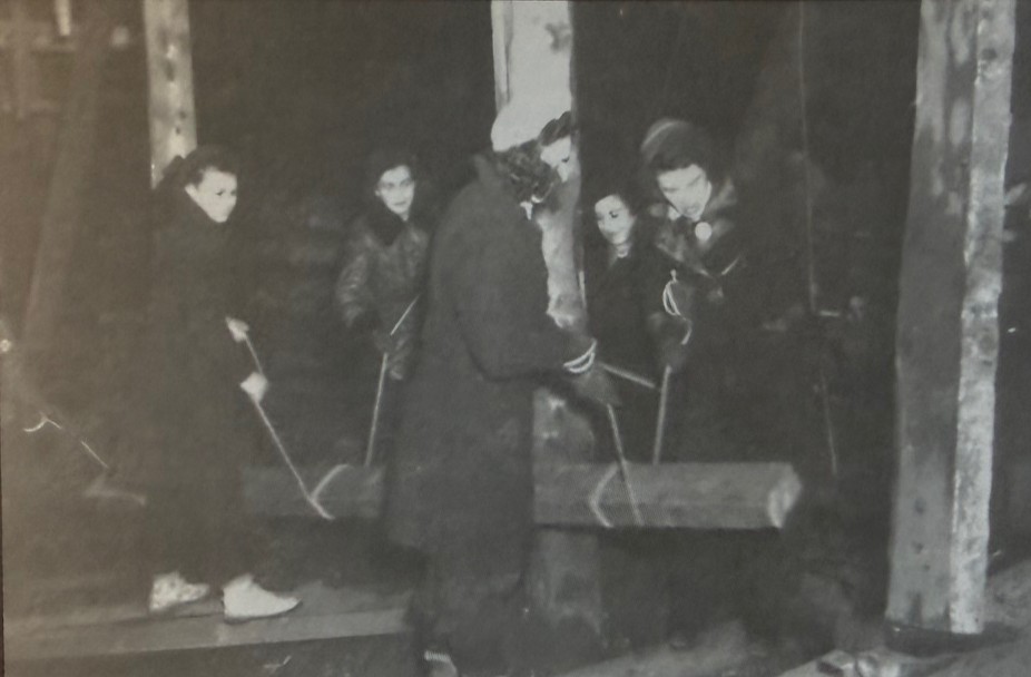
Canada's wartime shipbuilding demanded total national commitment, with government campaigns urging every citizen to contribute to the war effort against Axis threats. Factories and yards became symbols of unity, where skilled tradesmen worked alongside novices in round-the-clock shifts to meet impossible deadlines. Women played pivotal roles, breaking barriers as welders, riveters, crane operators, and electricians—thousands entering the workforce for the first time, their hands on torches forging the hulls that sustained Allied convoys. This collective sacrifice turned sleepy shipyards into arsenals of freedom, producing vessels like Park ships in record time despite material shortages and blackout drills.
Launched as Camp Farnham amid 1943 urgency, renamed Dufferin Park to join her sisters—then Dufferin Bell for Maritimes trade.
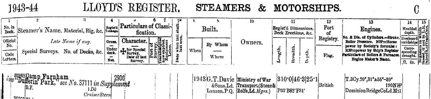
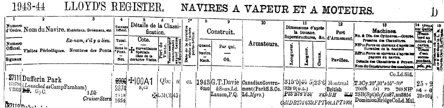
SS Dufferin Bell
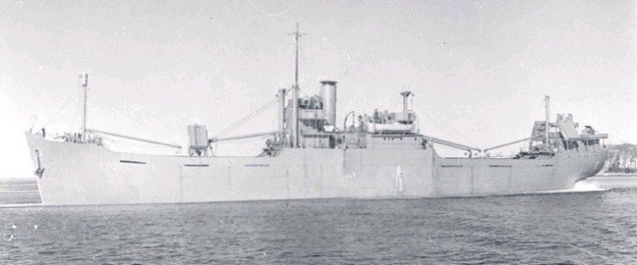
Launched as a standard Park ship "4700-tonner," SS Dufferin Bell measured 441 feet in length overall (LOA), with a 56.5-foot beam, 34.5-foot depth, and 2,874 gross register tons (4,719 deadweight tons). Her coal-fired triple-expansion steam engine delivered 475 nominal horsepower to a single screw propeller, pushing the freighter to 11 knots on efficient coastal runs. Three derrick-equipped masts served five cargo holds optimized for grain, timber, or bulk—self-unloading design that defined her postwar trade. By 1951, wartime bow gun mounts were long gone, leaving a utilitarian hull stripped for commerce, vulnerable without DEMS defenses when fog turned Framboise's ledges lethal. Today, divers find her flattened boilers, winches, and shaftline echoing that robust wartime blueprint amid the scatter.
There were 43 of the 4700-tonner ships built, 24 of (over half- built in Pictou, Nova Scotia) some with many name changes and use post war, others did not survive the war. Those known to have wrecked include:
| Wartime Name | Postwar Name(s)/Fate |
| Avondale Park | Sunk by U-boat 1945 |
| Beresford Park | Federal Ambassador → Gerda Toft (sank 1954) |
| Crescent Park | Julia → Lona → Senator Hagelstein → Agia Sophia → Manos Lemos (wrecked 1969) |
| Dufferin Park | Dufferin Bell (wrecked 1951 Framboise Cove) |
| Kensington Park | Docteur Yersin (wrecked 1953) |
| Lansdowne Park | Caribbean Trader (wrecked 1963) |
| Montmorency Park | Docteur Angier (wrecked 1949) |
| Taber Park | (sunk 1945 U-boat) |
| Taronga Park | Merian (wrecked 1977) |
| Victoria Park | (Torpedoed 1945; Pictou lead ship) |
| Wentworth Park | Azar (wrecked 1968) |
While no photos of SS Dufferin Bell exist, the following photos depict ships from the same Modified Scandinavian-class Park ships (4,700 DWT), conveying the compact size (~420 ft LOA) that helps readers visualize her vast, scattered wreckage in Framboise Cove's shallows.
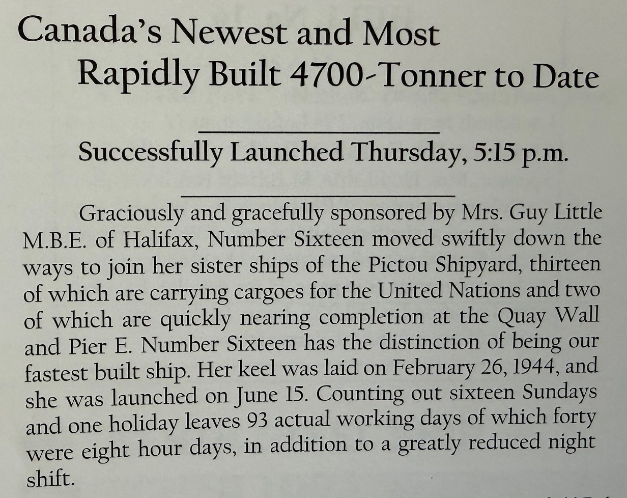
To meet the wartime effort, these ships were built in record time. Articles at the time confirmed the incredible speed and effort that was required. Ships were recorded as being completed in under 4 months from the keel being laid to launching.
Service History
Detailed voyage records for SS Dufferin Bell (ex-Camp Farnham/Dufferin Park) are scarce, typical for "workhorse" Park ships whose logs faded postwar—fueling the "lost to records" allure. Launched amid 1943 urgency, she likely convoyed bulk cargoes like grain, timber, or ore across the North Atlantic, dodging U-boats with DEMS gunners and zigzags en route to UK/Mediterranean ports. Managed by Pickford & Black Ltd. for Park Steamship Co. (Montreal), her wartime service mirrored sisters: essential supply runs sustaining Allied armies, possibly Halifax-to-Liverpool hauls amid vital North Atlantic convoys.
Post-VE Day (1945), sold 1946 to Picbel Ltd. (Halifax), she shifted to coastal peacetime trade—her final leg from Saint John, NB, to Louisbourg, NS, laden unknown, perhaps gypsum or fish meal common to Maritimes freighters. No crew manifests or logs surface publicly; Lloyd's/Wrecksite note only the May 1951 end, suggesting routine runs until fog claimed her at Framboise. This opacity echoes Park fleet's fate—hundreds scrapped, histories buried like her hull.
The Wreck Climax
As dusk settled over Framboise Cove on May 13, 1951, the Dufferin Bell was already in trouble. The 2,874-ton freighter had crept in toward Cape Breton’s southeast coast on a coastal leg from Saint John to Louisbourg, trading the open Atlantic for a deceptively tight approach along a lee shore. In fog or low visibility—routine on that coast in spring—she found rock instead of safe water, driving hard aground on the cove’s outer ledges. Steel on stone would have been audible for miles: a long, grinding shudder as frames twisted and plates opened to the sea.
Once stranded, the ship’s fate shifted from navigation to survival and salvage. With no loss of life reported, the crew’s first battle was simply to get off safely—boats over the side, lines rigged to the shore, and a cold, wet scramble onto the rocks while the hull worked under them. Messages went out for assistance, and within days a tug—likely one of the Foundation fleet working out of Halifax and Louisbourg—arrived to try to pull her free. But a Park ship’s deep, boxy hull wedged onto a rising and falling swell is a stubborn thing; every tide and wave only set her higher on the jagged bottom.
The more the Atlantic pounded her, the more the Dufferin Bell ceased to be a ship and became a wreck. Bulkheads buckled, cargo shifted, and any hope of refloating her slipped away as surveyors and insurers weighed the cost of salvage against her residual value in a market already flooded with surplus wartime tonnage. In the end, she was written off where she lay, a total constructive loss on a remote Cape Breton shore. The Park ship that had survived the Battle of the Atlantic was finally undone not by a torpedo, but by a foggy approach, a hard rock ledge, and a coastline that has claimed vessels for centuries—leaving her story, and even her captain’s name, largely lost to record.
Diving the Wreck
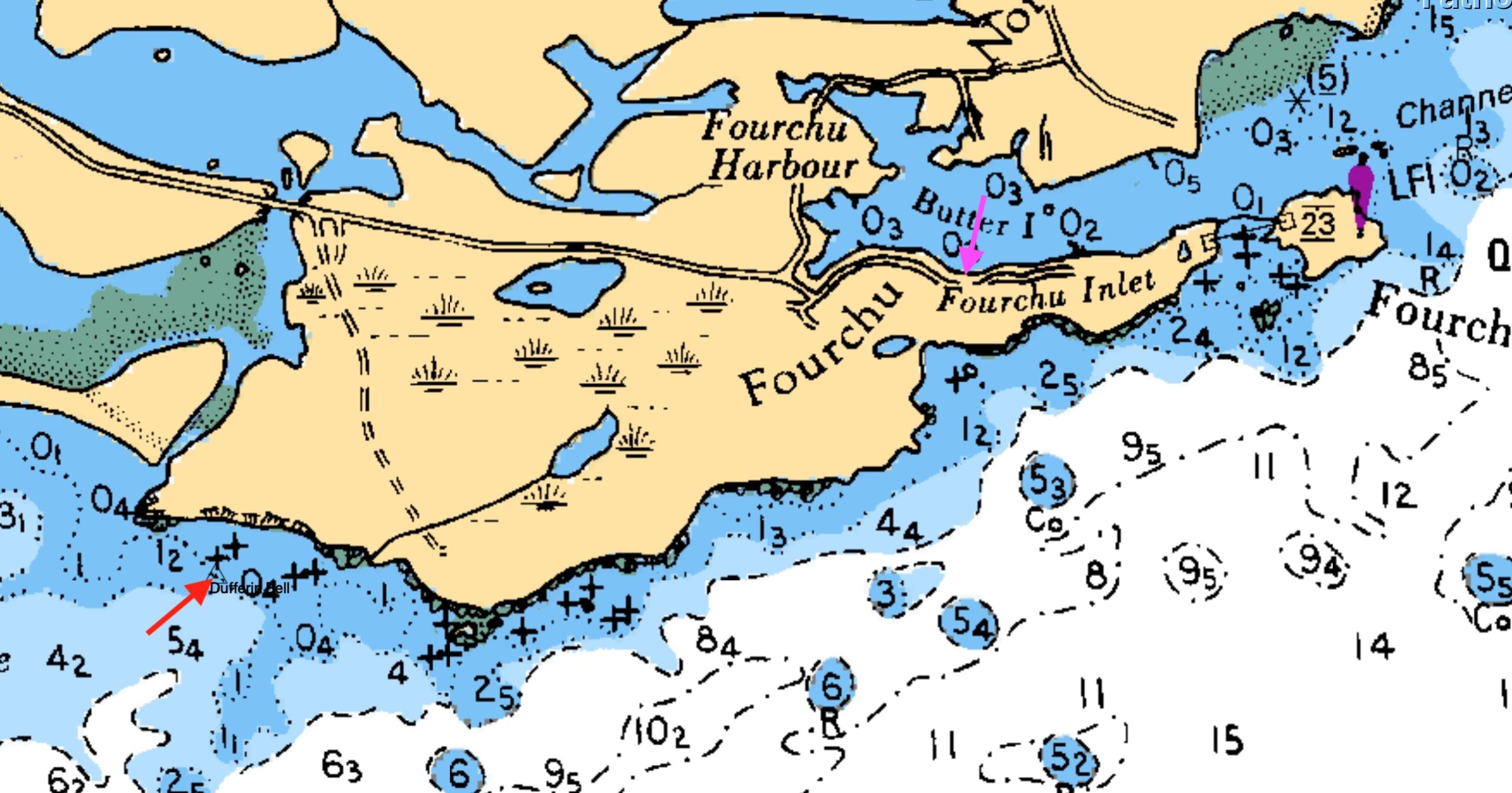
My last dive on the Dufferin Bell wreck came in August 2025, a rare calm day on Framboise Cove's treacherous ledges where the old Park ship lies scattered like shrapnel from an exploded can of pop. Pinpointing the shaftline at 45°42.251' N, 60°17.620' W—flattened against the ocean floor amid a debris field of twisted plates and recognizable fittings—felt like victory after the site's usual "washing machine" chaos. Proximity to shore amplifies every swell, cliffs funneling waves into a violent churn; only slack tide or glass-flat seas make it diveable, rewarding patience with intact boilers, winches, and propeller remnants still identifiable after 74 years underwater.
Launch from the unmarked slip on St. Peters-Forchu Extension Road demands local savvy—no tie-ups, just a rough concrete ramp hugging Forchu Inlet's edge, with gravel shores and minimal amenities. Visibility hovered 10-20 ft that day, schools of fish parting as we finned amid the wreckage, magnetometer pings from prior SeaSpy hunts confirming the spread. It's raw Cape Breton diving: no crowds, big currents if mistimed, but artifacts whisper of wartime grit—perhaps a forgotten valve or gauge from her Davie yard days can still be viewed.
Access Details
The boat slip for accessing Dufferin Bell is precisely at 45°42.953' N, 60°14.977' W, an unmarked gravel pull-off on the St. Peters-Forchu Extension Road (Route 320) along Forchu Inlet's western shore. This rough concrete ramp—visible as weathered slab amid kelp-fringed gravel—offers no dock, cleats, or amenities; beach small rigid-hulls like your Highfield Patrol at mid-to-high tide to dodge mudflats.
From here, motor ~2-3 km southeast to wreck coords (45°42.251' N, 60°17.620' W), eyeing CHS Chart 4417 for the "false passage" reef that vanishes at high water—stay offshore or risk grounding like the Bell herself. Local knowledge rules; no facilities mean pack fuel, gear, and comms for this remote Cape Breton launch. For fellow wreck hunters, mark calm forecasts, rig reef lines, and launch early; this one's a diver's puzzle, pieced from chaos.
Plan Your Forchu Expedition
Getting There:
5-hour drive from Halifax via Highway 102 to Truro, then off the ramp to the right towards Cape Breton Island. Continue Highway 104 through New Glasgow and Antigonish to the Canso Causeway. Cross the Canso Causeway and head southeast via Highway 320 toward St. Peter’s, then local roads (route 320/247) to Forchu/Forchu Harbour. Be cognisant of the narrower roads toward the end of the trip. Amenities including fuel are scare on the local roads.
Alternately, once arriving at Canso Causeway, travel towards Sydney over Kelly’s Mountain and in towards Marion Bridge. Modern GPS have lots of support.
Lodging & Dining:
Forchu has no hotels, inn, restaurants or stores. Alternates include
- Peck’s Cottages in Lousibourg
- Modern hotels in Sydney
Diving:
- Bring your own boat or contact local fishermen at Forchu to arrange charters
- Primary: Dufferin Bell (45°42.251' N, 60°17.620' W )
- Secondary: Yet to be determined, but area has other wrecks yet unfound.
Local Resources:
Forchu has no listed Harbour Authority Contact. The harbour operates through a lease agreement with Small Craft Harbours, a branch of Fisheries and Oceans Canada (DFO).

Legacy
The Dufferin Bell endures as a shattered testament to Cape Breton's unforgiving coast and Canada's wartime shipbuilding legacy—a Park ship born in frenzy, lost to fog and rock, her captain's name and full voyages faded like hull plates under kelp. From Davie's Lauzon ways to Framboise Cove's debris field, she whispers of U-boat dodges, postwar scrambles, and the raw Atlantic that claimed her on that fateful May day in 1951.
Yet in her scattered remnants—boilers, winches, shaftline at 45°42.251' N, 60°17.620' W—lies a diver's goldmine of artifacts to see and identify, but to leave untouched, accessible from Forchu's unmarked slip (45°42.953' N, 60°14.977' W) on calm days when the "washing machine" relents. For wreck hunters, she's prime for rediscovery: a puzzle of recognizable artifacts amid cod runs and currents, fueling NS maritime tourism one dive at a time.
Lost to records? Perhaps—but not to those who fin through her chaos. Mark the tides, dodge false passages, and let her story surface for the next generation of explorers.
Wreck Coordinates:
Dufferin Bell: 45°42.251' N, 60°17.620' | 20-40 ft | Sand/Rock
Boat Ramp: 45°42.953' N, 60°14.977' W
Vessel Specs: Dufferin Bell — 2874 GRT, 440 ft × 57 ft, Steel Hull
Modern survey technology—when paired with rigorous historical research and professional dive operations—continues to reveal and preserve the stories of vessels long thought lost to time and tide. The Forchu region stands ready to welcome the next generation of maritime explorers.
Dive Safety Notice:
Professional dive operations are strongly recommended. Strong tidal currents, and challenging sea conditions require proper training, equipment, and local knowledge. These shared coordinates now guide future explorers, blending SCUBA with Nova Scotia's maritime heritage.
The confirmation of the Dufferin Bell’s location represents a meaningful contribution to Atlantic Canada's maritime archaeology. The wreck's depth and documented historical record make it an exceptional site for future research, documentation, and recreational diving education. Modern survey technology—when paired with rigorous historical research and professional dive operations—continues to reveal and preserve the stories of vessels long thought lost to time and tide.
Ask me about the Highfield and Suzuki offshore expedition platform — engineered for serious divers.
#HighfieldHunter #HighfieldPatrol760 #SuzukiEngines #Suzuki-300hp #HalifaxShipwrecks #NSMaritimeHistory #DufferinBell #NovaScotia #CapeBretonIsland #DufferinBell

River Wye
The Tragic Fogbound End of the River Wye: A Nova Scotia Shipwreck Tale
Highfield Hunter
In the grey dawn of November 24, 1923, the British cargo steamer River Wye—a weathered survivor of World War I's brutal seas—met its end on the jagged rocks off Port Mouton Island, Nova Scotia. What began as a routine coal run from Saint John, New Brunswick, to Boston turned into a harrowing tale of fog, mis-navigation, and narrow escape, etching the ship's story into Atlantic Canada's maritime lore.
From Teesside Shipyard to Tramp Trader
Launched in 1906 as SS Glamorgan by Craig, Taylor & Co. Ltd. at their Thornaby-on-Tees yard on England's River Tees, the 3,576 GRT steel steamer measured 342 feet long with a 51-foot beam. Built for Jenkins Bros. of Cardiff (yard #~140), she was renamed River Wye later in her career. The yard, founded in 1885 amid Teesside's industrial boom, specialized in versatile tramps and colliers, producing over 300 vessels before closing in 1931 due to the Great Depression.
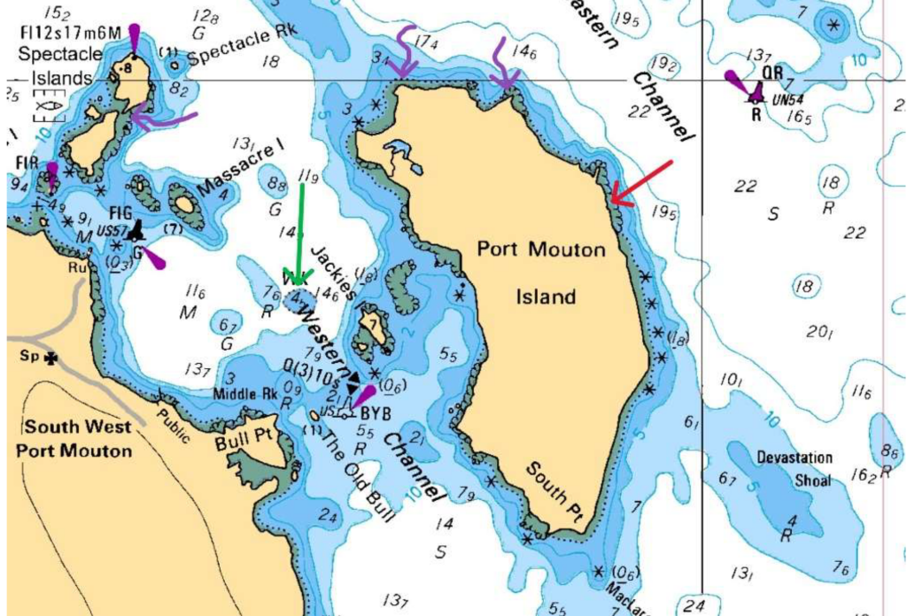
features, depth contours (5-22 meters shown), and marked wrecks (River Wye (red) and Matthew Atlantic (green, also
three potential wrecks (purple)). The stranding location aligns with charted shallow water and rocky hazards that claimed
the River Wye in 1923.
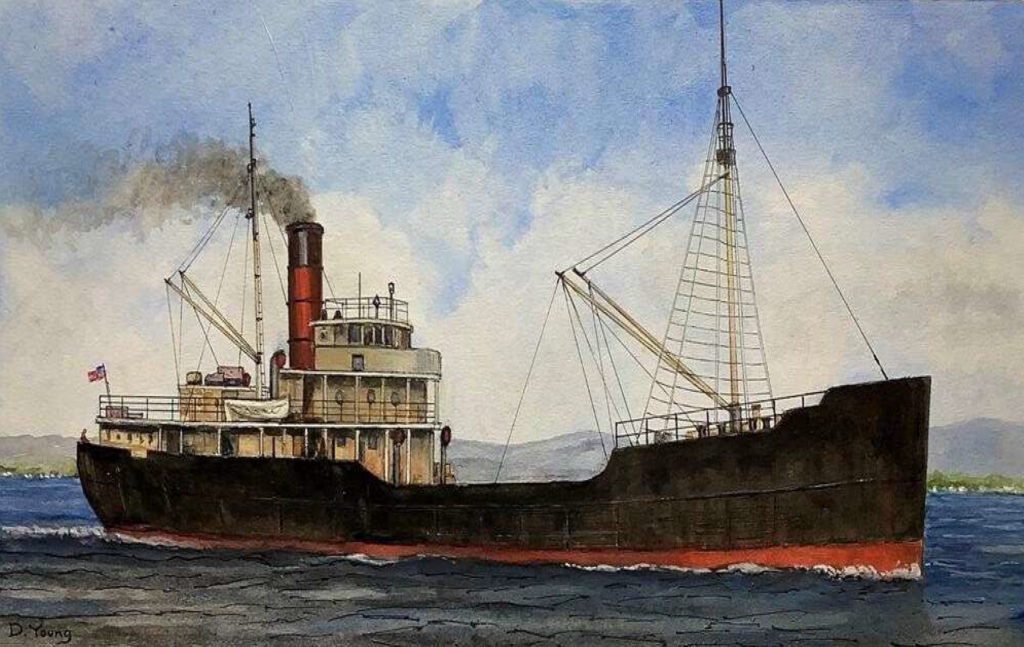
characteristic single red funnel, two-mast configuration, black hull with red anti-fouling bottom, and steel construction.
This vessel type exemplifies the tramp steamer design that defined River Wye's class and operational profile
River Wye embodied the era's tramp steamer life: shuttling coal from UK ports to South America, the Mediterranean, and North American grain/coal trades. Owned by Llewellyn, Merrett & Price of Cardiff—which managed the vessel through the post-WWI era—she passed hands following the decline of the traditional tramp steamer trade. No major incidents marred her record until that fateful 1923 voyage.
The Final Voyage: Fog's Deadly Deception
On November 22, Captain David Williams departed Swansea (UK) with 27 crew, loaded with coal for Boston (US). Fog rolled in thick off Nova Scotia's south shore, a notorious hazard for coastal shipping. From a prior fix at 44°46'N, 61°21'W, the ship steered S. 62° W at 7.5 knots, but without celestial sights, their position unraveled.
At ~6:15 a.m. on the 24th, lookout David Evans peered into the murk—visibility under 14 ship lengths (~250 yards)—and saw nothing until the crunch of rocks at Port Mouton Island (initial reports: 44°00'N 64°20'W). The ship stranded near the island amid stormy seas, becoming a total constructive loss valued at £40,000. Remarkably, no lives were lost; all hands abandoned ship and were rescued by the local Port Mouton residents.
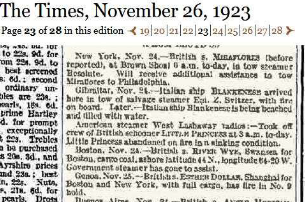
official notification of the vessel's stranding near Port Mouton Island and rescue of the crew.
Customs House, November 30, 1923, under Dominion Wreck Commissioner Capt. L.A. Demers, F.R.A.S
Precise Wreck Location and Accessibility
Updated coordinates pinpoint the site at 43°54.487' N, 64°45.418' W (decimal: 43.9081° N, 64.7570° W), off the island's east coast amid rocky ledges in 20-50 feet of water—ideal for recreational diving from Halifax, just a two-hour drive (~150 km southwest). This nearshore spot aligns with Port Mouton's nautical charts and local 1923 stranding records.
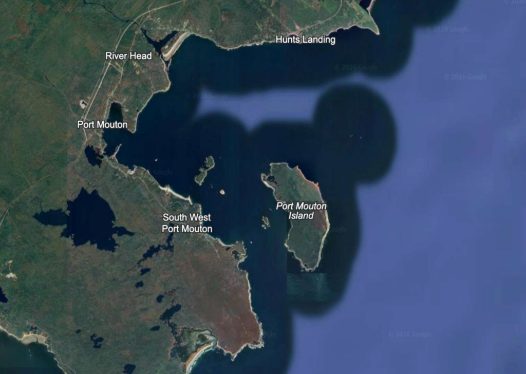
Point, Hunts Landing, River Head, and Port Mouton settlement. The wreck site coordinates (43°54.487'N, 64°45.418'W)
place the River Wye wreck off the island's east side amid rocky outcrops and shallow waters.
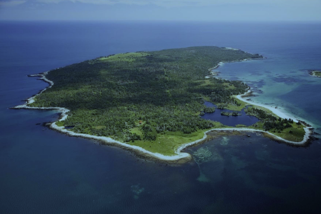
River Wye stranded on the eastern side (left side of photo. The rocky ledges and shallow offshore waters visible in this
image match the hazardous conditions documented in the 1923 inquiry records.
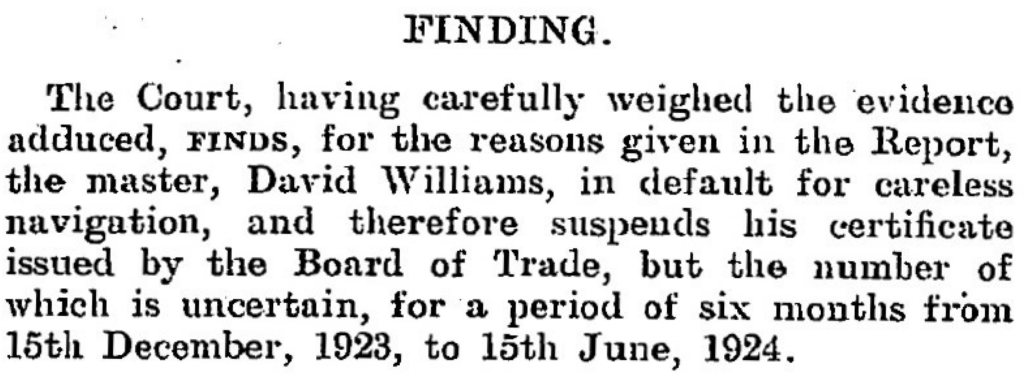
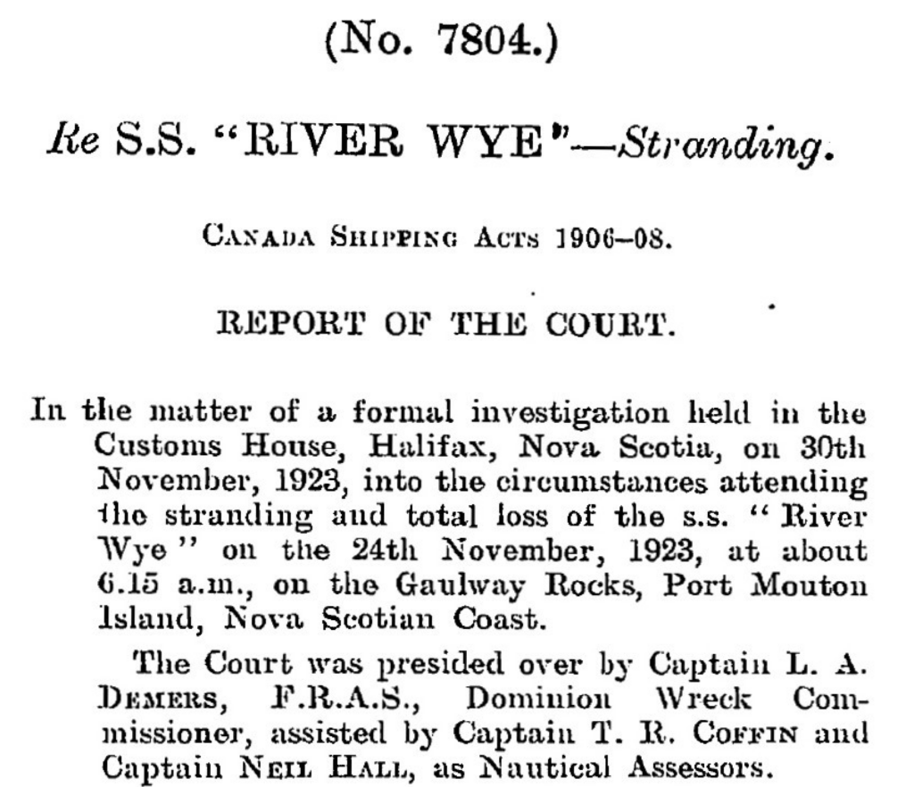
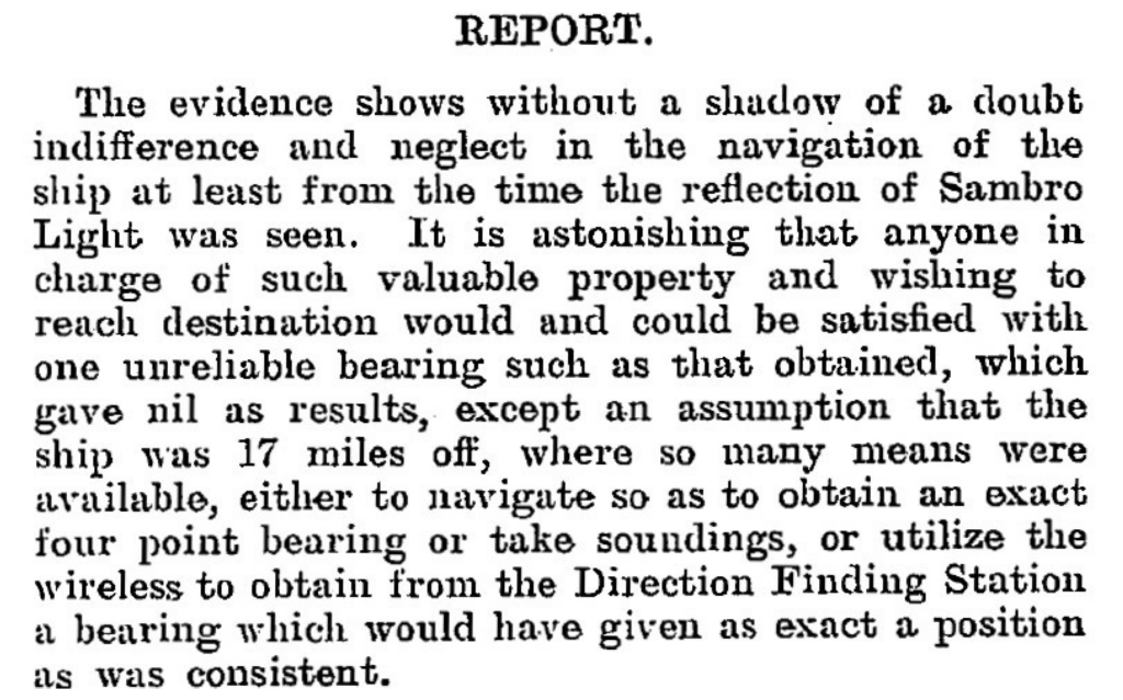
The Halifax Inquiry: Blame on the Bridge
The formal investigation (No. 7804) conducted November 30, 1923, at Halifax Customs House under Dominion Wreck Commissioner Capt. L.A. Demers, F.R.A.S., with Assessors Capt. T.R. Coffin and Capt. Neil Hall. Witnesses—Master David Williams, 2nd Engineer G.J. Humphrey, 2nd Officer J.E. Herbert, 1st Officer R. Jones, wheelsman J.T. Garnett, and lookout David Evans—detailed the haze post-unreliable noon fix (44°46'N 61°21'W) and single Sambro Light bearing. The Court condemned Williams' "indifference and neglect" for skipping soundings, Chebucto Head wireless bearings, or fixes despite SE winds; Herbert was censured for poor lookout amid visibility disputes (4-5 miles claimed vs. Evans' 1 shiplength). Williams' certificate was suspended 6 months (Dec 15, 1923–Jun 15, 1924); others mostly exonerated. The verdict highlighted the River Wye (3,576 GRT, Official No. 123170; Swansea to Boston) as lost to careless navigation on a prudent coast.
Port Mouton, a rugged outpost on Nova Scotia's "Gravely Coast," claims another chapter in the province's 20th-century wreck tally. River Wye's story endures as a cautionary saga of human error against nature's veil—her bones a potential gem for local maritime research.
Modern Rediscovery: Pinpointing with Side-Scan Sonar
Fast-forward a century: though previously dove, the wreck's precise coordinates were elusive until August 31, 2025, when—operating from my Highfield Patrol 760—I towed side-scan sonar across promising sections near Port Mouton Island. The Patrol 760 handled the towing configuration flawlessly, maintaining stable positioning even in choppy tidal currents, while high-resolution acoustic imaging revealed a distinctive "feather-like" shadow.
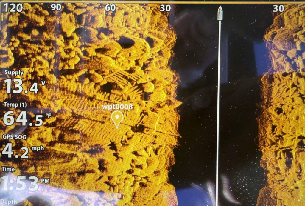
hull structure. The high-resolution sonar data clearly reveals the exposed ribs and framing of the steamer wreck. Waypoint
wpt0008 marks the sonar contact at coordinates 43°54.487'N, 64°45.418'W. The sonar target display shows supply voltage
13.4V, temperature reading 64.5°F, and GPS speed-over-ground of 4.2 mph, documenting the precise survey conditions.
Depth indicator: approximately 30 feet.
This methodical survey paid off with the shipwreck finding, validated by subsequent diving; Highfield's rugged aluminum design proved essential to this breakthrough, enabling precise gear deployment where lesser boats would struggle. Today, the wreck features lots of wreckage to explore including a 120-foot shaftline precariously spanning large boulders, offering recreational divers a thrilling swim-under passage.
Experience Maritime Nova Scotia: Legacy & Discovery
The River Wye rests in 20-50 feet of Atlantic waters—accessible yet challenging—a time capsule of Edwardian maritime tragedy. Port Mouton Island represents everything Atlantic Canada offers: rugged coastline, fishing heritage, protected harbors, and underwater archaeology. The River Wye discovery showcases modern survey capability meeting historical passion—available now to divers, researchers, and maritime enthusiasts.
From Highfield's aluminum hull weathering choppy seas to local fishing charters supporting certified divers, the region's economy has access and adventure. The 988-acre island's white-sand beaches and wooded trails complement world-class wreck diving. Port Mouton is considered the largest private island on the east coast. This shallow wreck exemplifies Nova Scotia's untapped maritime potential: dozens more lie undocumented along the south shore, waiting for the next generation of Highfield Hunters. Your dive could be the next rediscovery.
Plan Your Port Mouton Expedition
Getting There: 2-hour drive from Halifax via Highway 103 to Exit 21. Turn left on Port Mouton Connector Road, then right on Number 3 Highway. Continue left on Central Port Mouton Road, then left again on Central Port Mouton Breakwater Road to harbor access (15 min west of Liverpool).
Lodging & Dining:
- Port Mouton Bay Cottages & Restaurant
- Quarterdeck Resort, Summerville Centre
- White Point Beach Resort, Hunts Point
Diving:
- Bring your own boat or contact local fishermen at Port Mouton Harbour to arrange charters
- Primary: River Wye (43°54.487' N, 64°45.418' W | 20-50ft | east side island)
- Secondary: Matthew Atlantic artificial reef (~60ft | inboard side of Port Mouton Island | marine life hotspot)
Local Resources:
- Port Mouton Harbour Authority: 902-683-2555
Wreck Coordinates:
- River Wye: 43°54.487' N, 64°45.418' W | 20-50 ft | Sand/Rock
- Boat Ramp: 43°55.135' N, 64°50.616' W
Vessel Specs: River Wye — 3,576 GRT, 342 ft × 51 ft, Steel Hull, 120-ft Shaftline
Modern survey technology—when paired with rigorous historical research and professional dive operations—continues to reveal and preserve the stories of vessels long thought lost to time and tide. The Port Mouton region stands ready to welcome the next generation of maritime explorers.
Dive Safety Notice: Professional dive operations are strongly recommended. Strong tidal currents and challenging sea conditions require proper training, equipment, and local knowledge. These shared coordinates now guide future explorers, blending SCUBA with Nova Scotia's maritime heritage.
The confirmation of the River Wye's location represents a meaningful contribution to Atlantic Canada's maritime archaeology. The wreck's depth, proximity to Halifax, and well-documented historical record make it an exceptional site for future research, documentation, and recreational diving education. Modern survey technology—when paired with rigorous historical research and professional dive operations—continues to reveal and preserve the stories of vessels long thought lost to time and tide.
Mentioned In